Seen from Space 2009
The Castle in the Air – Machu Picchu in Peru |
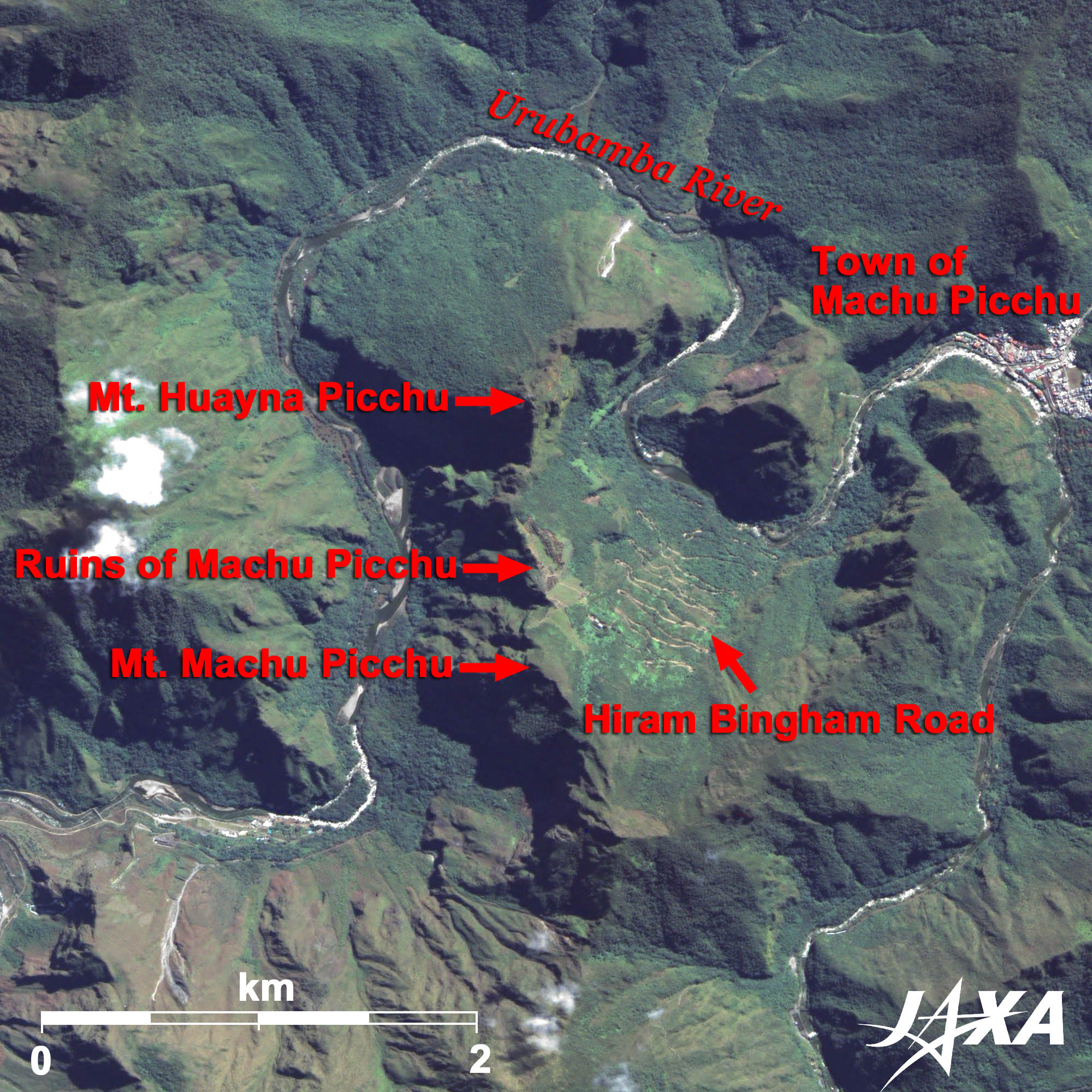 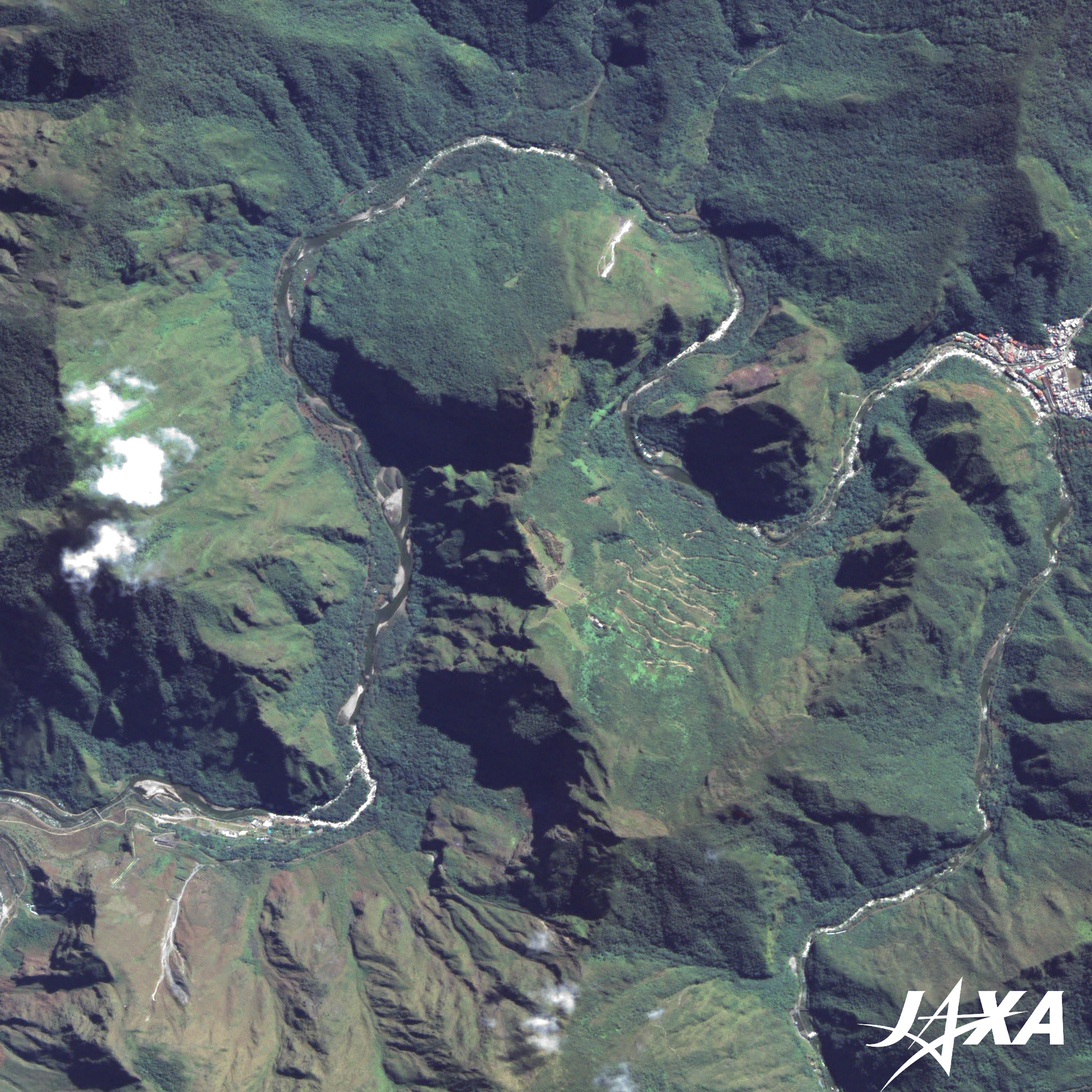 Fig. 1. Enlarged Image of Machu Picchu in Peru
Machu Picchu(kmz, 3.86MB, Low Resolution) as seen on Google Earth. 
Discovery of Machu PicchuFigure 1 shows the enlarged image of Machu Picchu in Peru, the ruins of the Inca Empire. Machu Picchu is situated on a mountain ridge 2,400 m above sea level, along the Urubamba River in Peru, 80 km northwest of Cuzco which was the capital of the Inca Empire. Machu Picchu is not seen from the foot of the mountains, and therefore, has been called "The Castle in the Air" or "The Lost City of the Incas". The ruins of Machu Picchu are located between the two peaks of Machu Picchu (2,940 m) and of Huayna Picchu (2,690 m). Machu Picchu means "The Old Peak" and Huayna Picchu means "The Young Peak" in the Quechua language. The ruins of Machu Picchu are the most famous ruins of the Inca Empire. The Incas started to build Machu Picchu around AD 1430 but abandoned it a hundred years later, at the time of the Spanish conquest of the Inca Empire. It had been known locally, but it was brought to worldwide attention in 1911, when Hiram Bingham, an American historian employed as a lecturer at Yale University, was led up to Machu Picchu by a local boy, while exploring the old routs in this area. He published a book titled The Lost City of the Incas. Since then, Machu Picchu has come to be known worldwide (around the world). On the image, you can see a winding mountain road from the Urubamba valley to the ruins. This road was constructed by the Peruvian government in the 1940s and is now called Hiram Bingham Road. Many tourists have visited the ruins via this road. At the right (east) end of the image, you see the town of Machu Picchu (formerly called Aguas Calientes) . Aguas Calientes means "hot spring" in Spanish and there is an open-air hot spring on the outskirt of town. It is also a terminal of the luxury train (Hiram Bingham Train) from Cuzco.
Was Machu Picchu an observatory of the Inca Empire?Machu Picchu was not found by the Spanish and consequently not plundered and destroyed. Therefore, the ritual stones and the Inca style buildings have remained untouched. It is a good place to learn about the classical Incas cultural style. Machu Picchu was originally thought to be the last fort against the Spanish invasion. There is an open view of both the east and the west. Because of this, Machu Picchu is now thought to have been a point to observe astronomical events such as the vernal equinox and the autumnal equinox, which would have been important to the Incas who worshiped the Sun. But there remain many mysteries about Machu Picchu. Machu Picchu was designated as a World Heritage Site in 1983 together with Cuzco. Machu Picchu now faces the environmental degradation caused by the construction of bridges and roads and the increase of tourists. 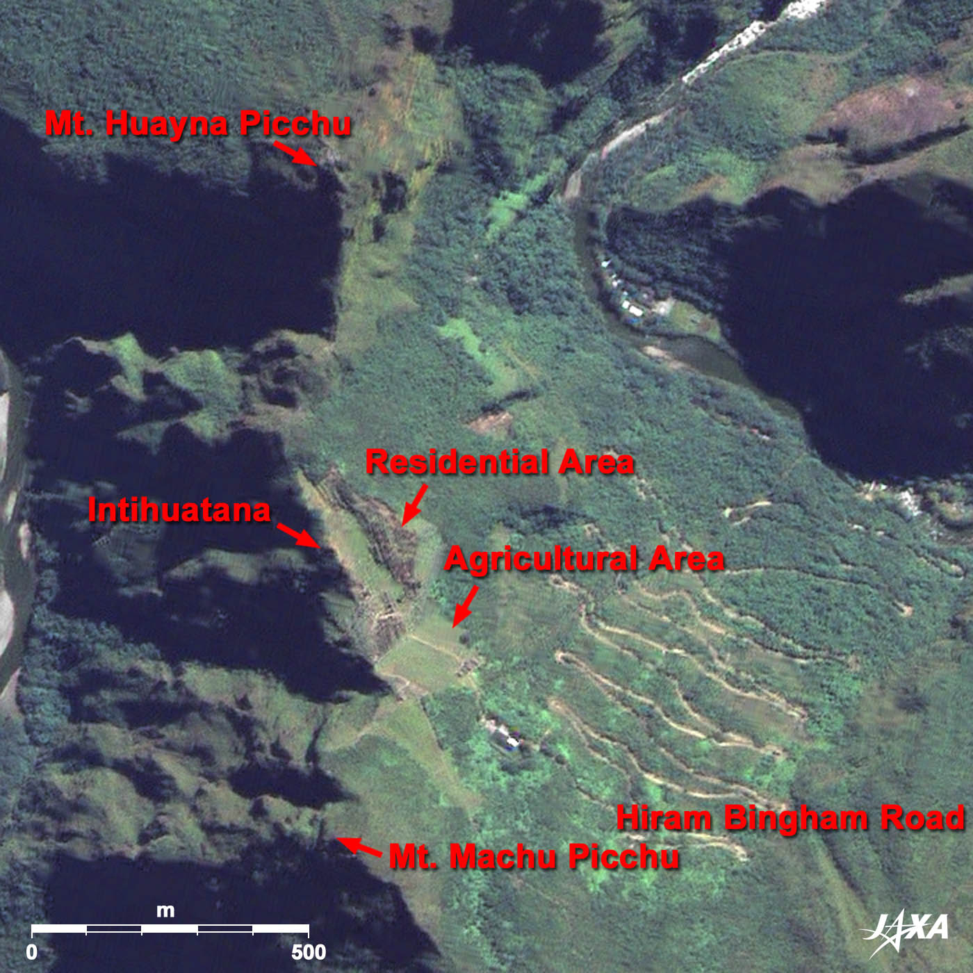  Fig. 2. Enlarged image of the ruins
Figure 2 shows the enlarged image of the ruins. This ruins of Machu Picchu consist of a residential area and an agricultural area. The upper part (north side) is the residential area and the lower part (south side) is the agricultural area. The agricultural area consists of forty terraced fields and the residential area consists of two hundred stone buildings and the temple. The Intihuatana stone is placed at the peak of the ruins. The Intihuatana is believed to have been designed as a solar clock. There is also a building at the top of Mt. Huayna Picchu called the "Temple of the Moon". 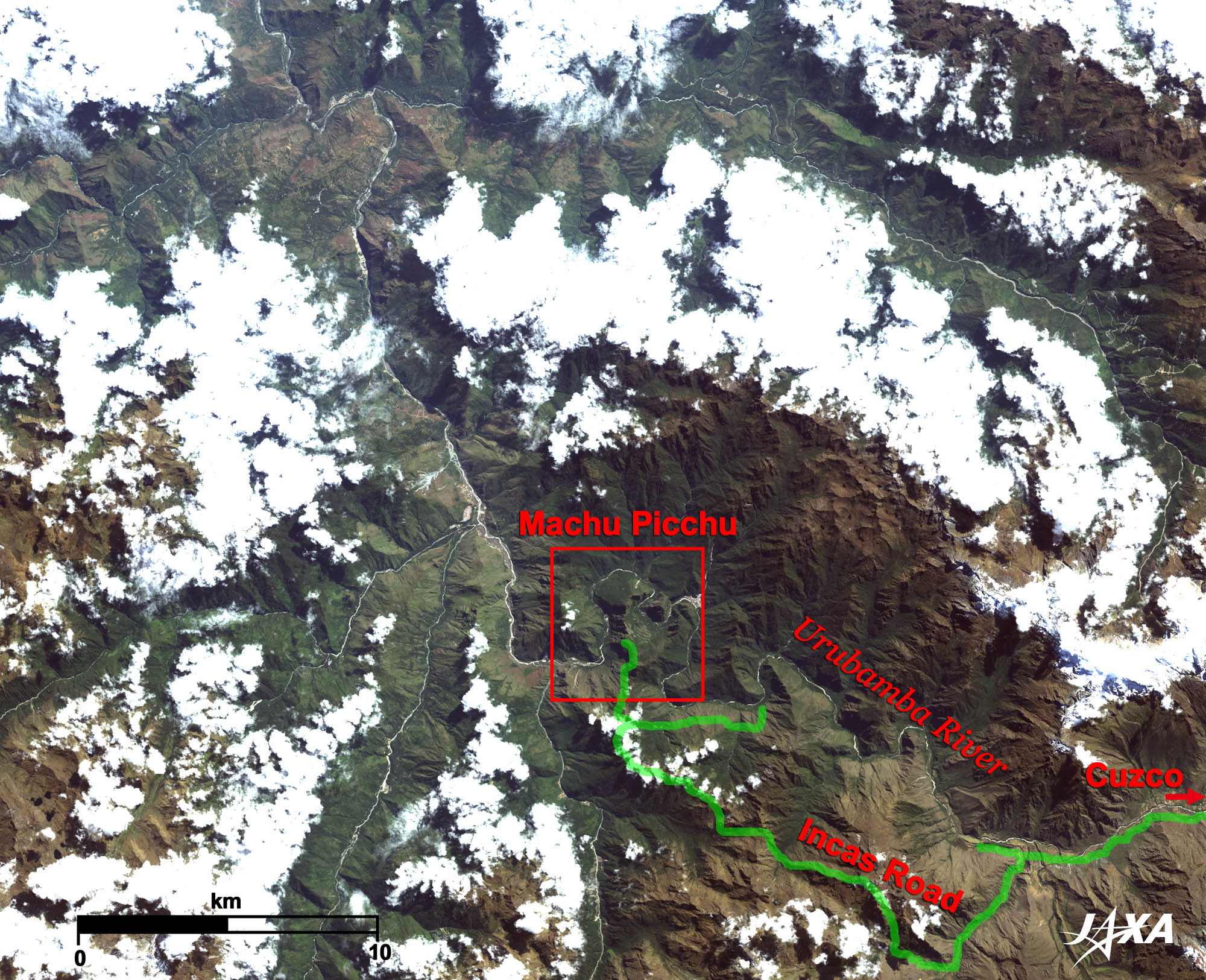  Fig. 3. Machu Picchu surroundings
Figure 3 shows the surroundings of Machu Picchu. Fortunately, Machu Picchu is not covered by cloud. The Urubamba River flows between the mountains and forms deep valleys. You can see the Incas road in the mountainous area at the south-east of the image. The Inca Empire constructed the main roads to rule the empire. Part of the road is now used as a trekking course. 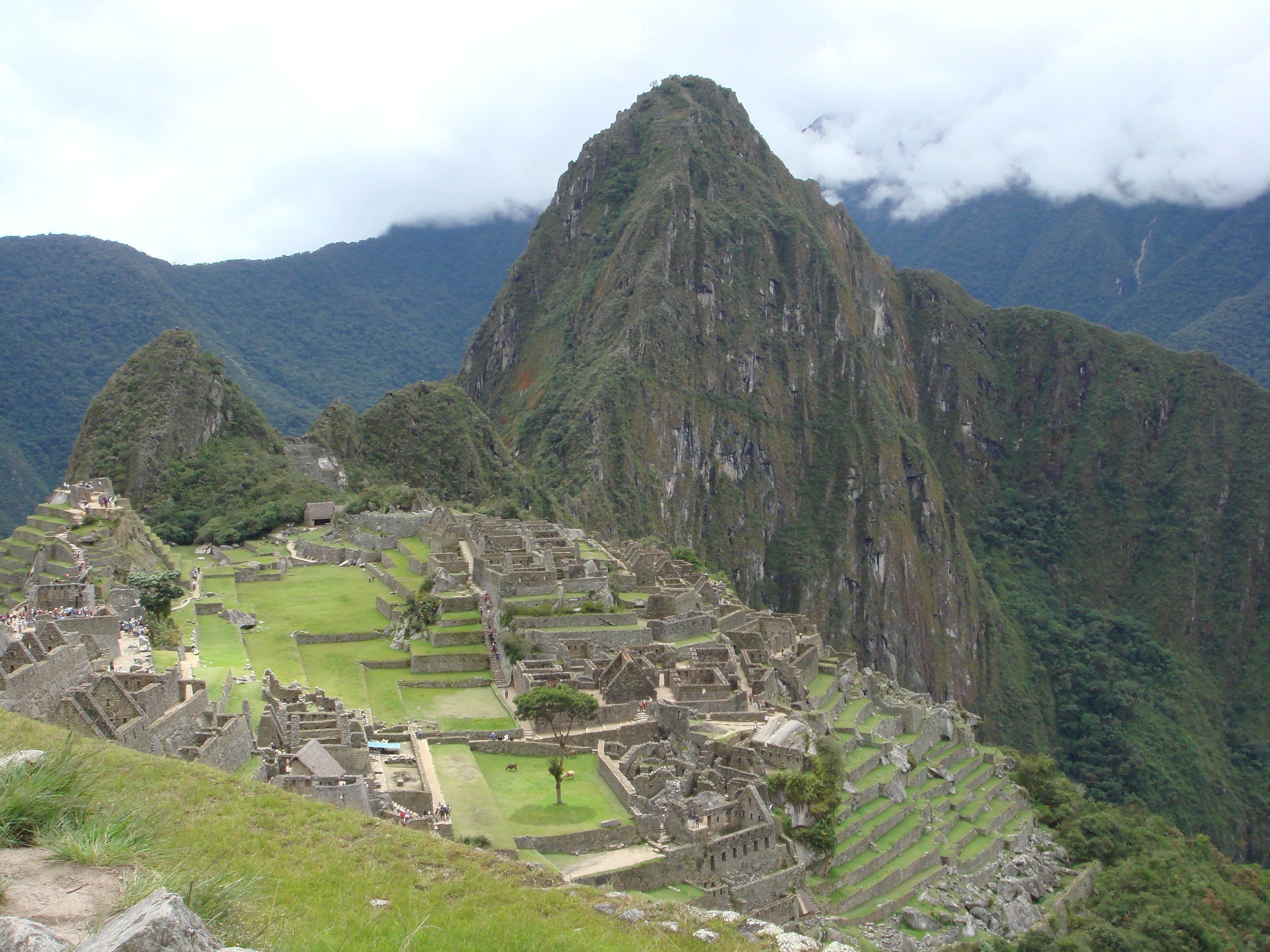 Photo View of the ruins of Machu Picchu and Mt. Huayna Picchu
This photo, taken at the agricultural area of Machu Picchu, shows the residential area and Mt. Huayna Picchu. As you see, Machu Picchu was constructed on a very steep slope of a mountain ridge. Explanation of the Images: (Click the images twice to enlarge.)
AVNIR-2 has four observation bands. Composite images are usually produced by assigning red to Band 3 (610 to 690nm), green to Band 2 (520 to 600nm), and blue to Band 1 (420 to 500nm). The resulting images have natural coloring, as if seen by the naked eye. Thus, the following colors designate ground objects.
Fig. 1, 2 |


