| |
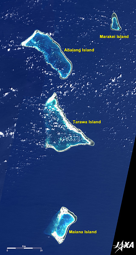 |
Fig. 1 Northern Gilbert Islands
The Gilbert Islands (kmz, 5.85MB, Low Resolution) as seen on Google Earth. |
Figure 1 is an image of the northern Gilbert Islands, comprising the Republic of Kiribati, as observed by the Advanced Land-Observing Satellite "Daichi" in 2008. Marakai Island, Abaiang Island, Tarawa Island, and Maiana Island can be seen aligned north to south. These are all flat, low coral-reef islands and atolls with lagoons.
"None of the atolls that make up our country are more than two meters above sea level. We will be submerged by the end of the century, as things stand right now. Entire villages are being relocated as the sea encroaches upon the land. People are being asked to move from places that have been home for them. It’s a human tragedy," said Anote Tong, the President of Kiribati, at a World Environment Day meeting in Wellington, New Zealand, on June 5, 2008.
Marakei Island is 27km in circumference and 200m to 2km wide and is shaped like a triangle. A thick green ring extends over almost the full circumference. The population is approximately 2700, according to a report for the 2005 Population Census.
Abaiang Island is 58km long and 50m to 1.5km wide and looks like a comb. Spindly areas of thick green extend without a break on the east side, but the land breaks off here and there with shoals on the west side. The population is 5500.
The capital of the Republic of Kiribati is located in Tarawa Island, shaped like the triangular sail of a yacht. The island is 67km long and 100m to 1.5km wide. The islets on the southern side are connected, but the islets on the northeastern side break off here and there, and the western side is formed by shoals. The population of North Tarawa is 5700 and that of South Tarawa is 40,000. The total of 45,700 comprises half of the population of the country.
Maiana Island is a rectangular shape with thick green land on the eastern side continuing without a break, but the white sandy beach on the western side looks flooded during high tide. It is 31km long and 50m to 1.25km wide, and its population is 1900.
The Republic of Kiribati extends into the vast area of sea in the Middle Pacific, from 169°E to 150°W and from 4°N to 11°S, and is composed of the Gilbert Islands in the west, the Phoenix Islands in the center, and the Line Islands in the east. The population in 2005 was 93,500.
 |
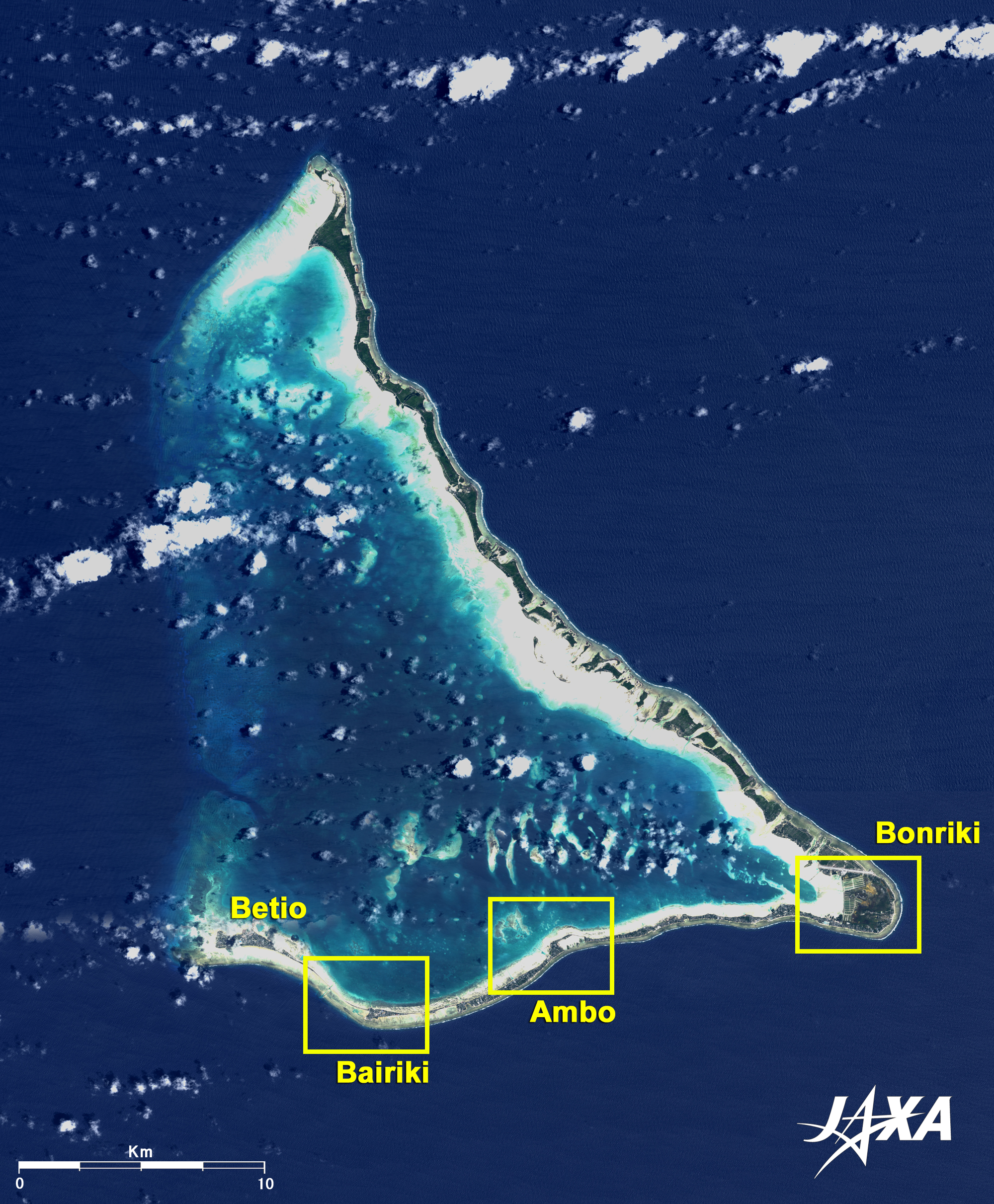
| Fig. 2 Tarawa Atoll |
Figure 2 is an image of Tarawa Island observed by Daichi in March and November 2008. Tarawa Island consists of 24 islets, with dark green islets in North Tarawa, to the north of Bonriki at the east end, broken here and there by white coral sands. The islets in South Tarawa, from Bonriki to Betio at the west end, are connected to each other by roads, including causeways.
South Tarawa is the capital of the Republic of Kiribati, and the court of Betio, the administration of Bairiki and the Parliament House of Ambo are located there. In Bairiki, there is Kiribati Campus of the University of the South Pacific, whose campuses are dispersed in 12 countries in the South Pacific.
Betio is the islet where the Japanese military fought against U.S. forces in the Battle of Tarawa in 1943, and there remains some wreckage of the guns of the Japanese military.
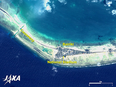 |
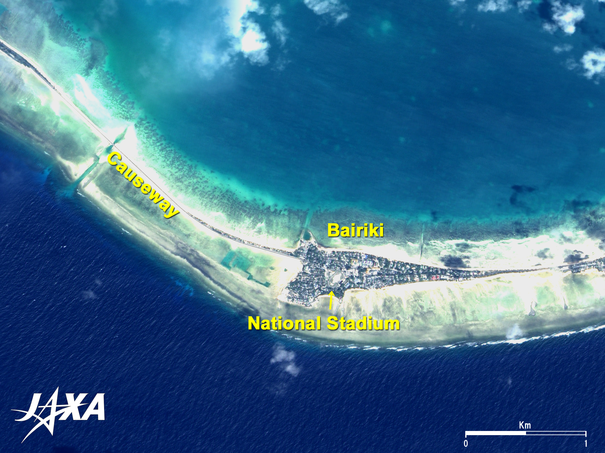
| Fig. 3 Bairiki |
Figure 3 is a pan-sharpened image of Bairiki observed by Daichi in December 2008. The National Stadium can be seen at the center of the figure. A thin causeway extends from Bairiki to the northwest and connects with Betio. Additionally, it can be seen that the ocean on the southern side of the land is so-called ultramarine (dark blue) in color and ruffling, whereas the coral-reef lagoon on the northern side is bright emerald-green, indicating shallow water, and there are no waves.
 |
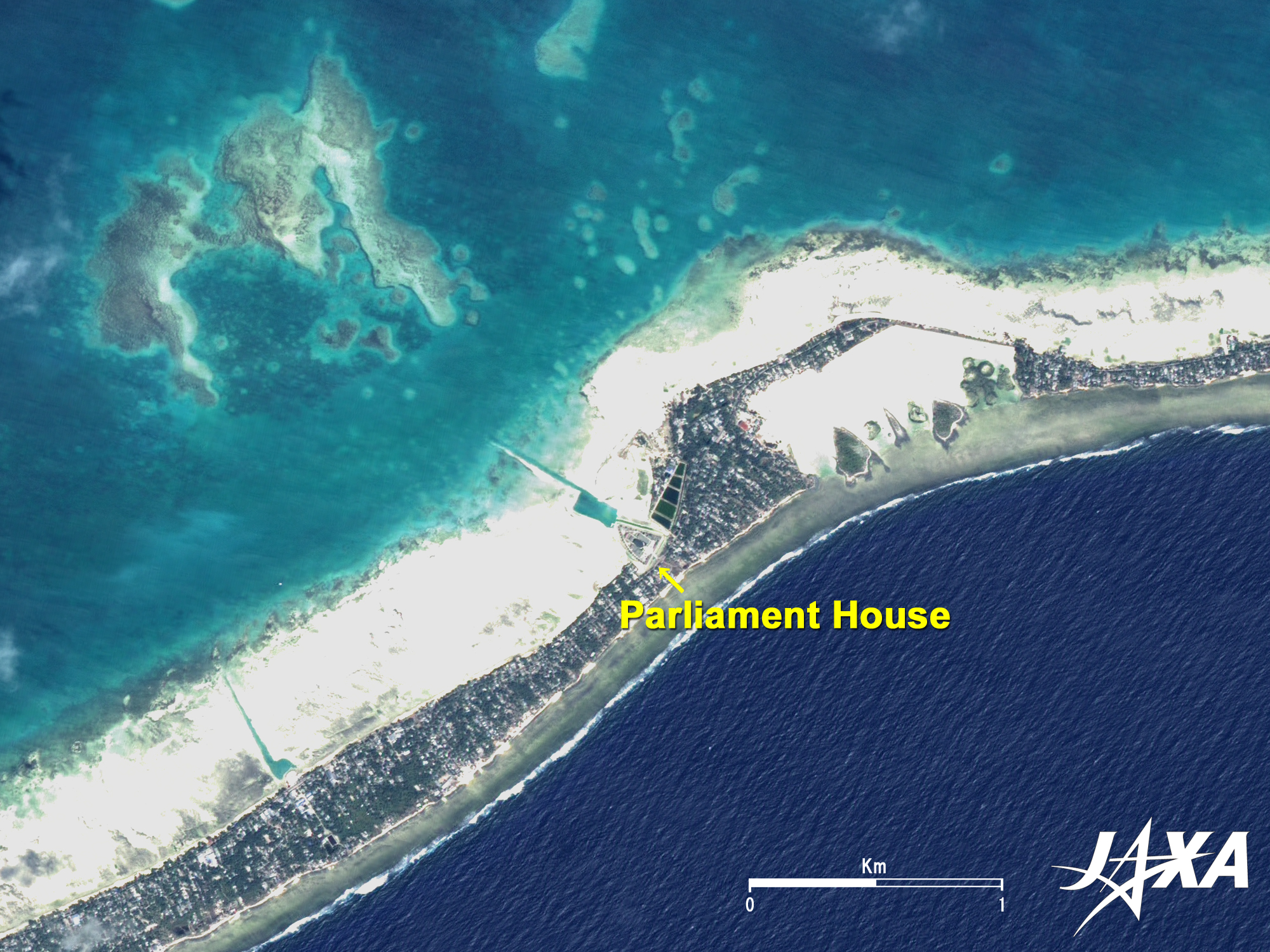
| Fig. 4 Ambo |
Figure 4 is a pan-sharpened image of Ambo observed by Daichi in November 2008. The Parliament House can be seen at the center of the figure. There is an emerald-green harbor on the northeastern side of the Parliament that connects with the coral-reef lagoon through a thin passage.
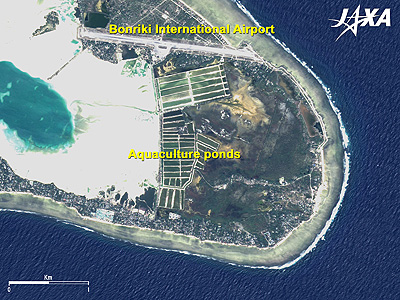 |
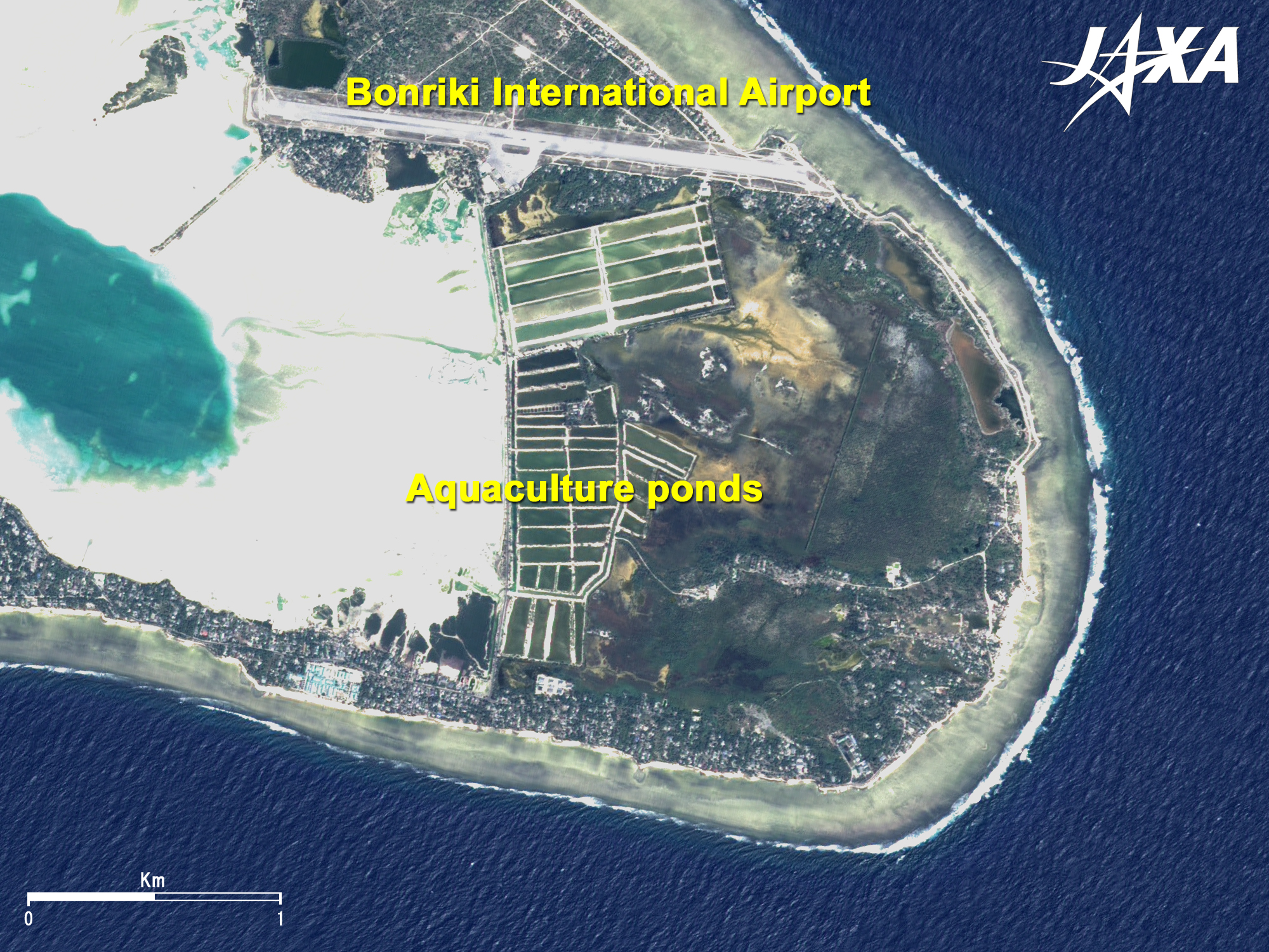
| Fig. 5 Bonriki |
Figure 5 is a pan-sharpened image of Bonriki observed by Daichi in November 2008. A runway of approximately 2100m at the Bonriki International Airport can be seen. There are some aquaculture ponds on the southern side of the airport.
Explanation of the Images:
(Click the images twice to enlarge.)
Figs. 1 and 2
AVNIR-2 has four observation bands. Figures 1 and 2 were produced by color-composing, assigning red to Band 3 (610 to 690nm), green to Band 2 (520 to 600nm), and blue to Band 1 (420 to 500nm). The resulting images have natural coloring, as if seen by the naked eye. Thus, the following colors designate ground objects.
| Green or ocher: |
Grass or farmland |
| Grey: |
City area or roads |
| Dark Blue: |
Deep sea surface |
| Emerald green: |
Shallow sea water |
| White: |
Clouds or coral sands |
| Black: |
No data |
The resolution of Fig. 1 was reduced to 40m in order to cover a wider area. The figure was produced by mosaicking five scenes observed on different days. The resolution of Fig. 2 was reduced to 20m as well.
Figs. 3 through 5
PRISM is an optical sensor for observing ground surfaces with visible and near-infrared signals in the 520 to 770 nanometer (one-billionth of a meter) band. The acquired image is monochrome. PRISM has three independent optical systems (telescopes) to acquire images for nadir, forward, and backward views at the same time so that terrain data, including altitude data, can be obtained. Only nadir images were used in this article.
The AVNIR-2 composite image was transformed into hue, saturation, and intensity, and the intensity was replaced by the PRISM image. The hue, saturation and intensity data were then reversed into a color image. The result was a virtual 2.5m ground-resolution color image. This kind of high-resolution color image, composed by combining a higher-resolution monochrome image and a lower-resolution color image, is called a pan-sharpened image.
Figures 3 and 5 present high-resolution, pan-sharpened images composed in this way. Colors represent the same features as in the above-mentioned AVNIR-2 image.
|
|