| |
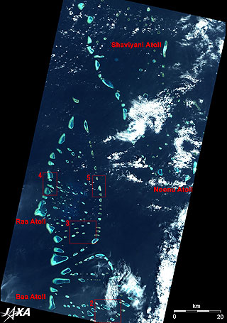 |
Fig. 1 Northwestern Part of the Republic of Maldives
Maldives (kmz,1.78MB,Low Resolution) is seen from Google Earth. |
Figure 1 depicts the northwestern part of the Republic of Maldives as observed by the Advanced Visible and Near Infrared Radiometer-2 (AVNIR-2) on board the Advanced Land Observing Satellite (ALOS) "Daichi" in January 2007. The Republic of Maldives is located in the Indian Ocean about 600 km southwest of India and Sri Lanka. This archipelagic country consists of 26 natural atoll reef islands and extends 754 km in the north- south direction and 118 km in the east- west direction. The figure covering a 140 km-long area in the north and south presents 1/10 of the whole country and includes a profile-looking Raa Atoll in the center, the northern half of Baa Atoll at the bottom, and a part of Shaviyani Atoll and Noonu Atoll at the top. The capital MalEis located 100 km south from the bottom edge of the figure and is not visible.
The word "Atoll" originates from the Maldivian Dhivehi word atholhu meaning "a coral reef island with a lagoon inside (1)". Many atolls literally dot the figure. Arabs, Chinese, and Europeans who once sailed the Indian Ocean likely called these islands "a pearl necklace." The name "Maldives" derives from the Sanskrit maladvipa, meaning "garland of islands."
There are 26 natural atolls (divided into 20 administrative atolls), and about 1,200 islets in the Republic of Maldives. About 200 islands are inhabited, and Maldivians are all Muslims. Since most of the islands are small enough to be rounded by foot, each island usually has only one function. Therefore, resort islands and residential islands are clearly divided. There are 100 resort islands, which belong to 12 atolls, and the basic policy is "one resort, one island." As much as 80% of the islands are less than 1m above the sea level.
Shaviyani Atoll in Fig. 1 consists of 51 islands and is located 192 km north of Malé. Kanditheemu Island in the atoll has a remnant of the oldest Maldivian written script called Thaana. More than 1,000-year-old pagodas from the age when Maldives was a Buddhist country still exist on Noonu Atoll (consisting of 71 islands) on the right of the figure. Stone sculptures were famous here for a long time.
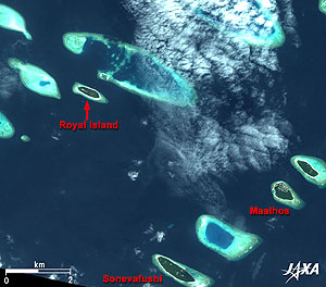 |
| Fig. 2 Close-up of Baa Atoll |
Figure 2 is a close-up of the part of Baa Atoll (lower part of Fig. 1) located 100 km north of Malé. Baa Atoll includes 75 islands, five of which are developed for resorts. It takes 35 minutes to fly to Baa Atoll by seaplane from MalEInternational Airport on Hulhule Island located 2 km from MalE or three hours by speedboat. It takes only 30 minutes to walk around Royal Island. An island dedicated as a harbor is visible to the north of Royal Island.
Soneva Fushi Island is a bit larger; it takes 75 minutes to walk around it. Two islands that have some kind of human intervention are visible to the northeast of Soneva Fushi. Maalhos Island is 765m long and 500m wide with a population of 500; a harbor is also visible.
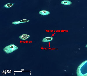 |
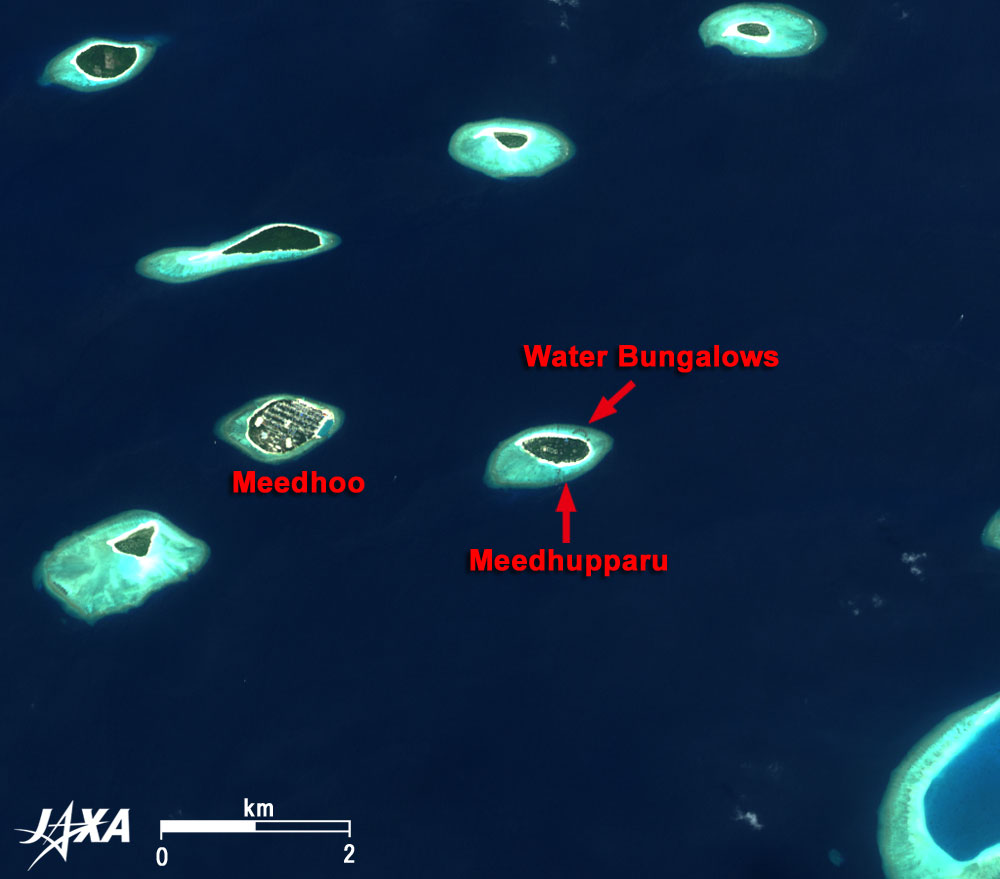
| Fig. 3 Close-up of Southern Raa Atoll |
Figure 3 is a close-up of the southern area of Raa Atoll including Meedhupparu Island, the only resort in Raa Atoll. It is located 130 km north of Malé and is a 40-minute flight by seaplane. Brownish water villas clustered in a crescent are visible to the northeast of Meedhupparu Island. Meedhoo Island, 825m long and 550m wide with a population of about 1,700, is visible to the west.
 |
 |
| Fig. 4 Close-up of Western Raa Atoll |
Fig. 5 Close-up of Eastern Raa Atoll |
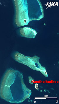
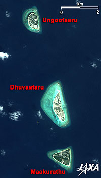
Raa Atoll consists of 88 islands. Figure 4 is a close-up of Kandholhudhoo and its vicinity in western Raa Atoll, and Fig. 5 is a close-up of Ungoofaaru in eastern Raa Atoll. Ungoofaaru, which is 775m long and 450m wide with a population of about 1,200, is the capital of Raa Atoll, and has an administration office, a police station, a school, and a hospital. The white square in the south of the island is a cluster of tsunami tents for the people left homeless by the tsunami in December 2004. Dhuvaafaru was an unmanned island, but it has been developed for the people of Kandholhudhoo Island in the west of the Atoll, where the whole island was terribly ravaged by the tsunami. The development will be completed in January 2008. Kandholhudhoo was a small island, 485m long and150m wide with a high population of 2,700 (2). People of this island are now living in separate islands. Triangular Maakurathu Island is 925m long and 825m wide with a population of 900.
Fisheries and Tourism form the two key components of the Maldivian economy. Tourism accounted for 32% of the GDP in 2004. About 601,000 tourists visited Maldives (local inhabitants are 299,000) in 2006. This number is equivalent to the peak year in 2004 (616,000), which indicates tourists are coming back from the low of 395,000 tourists in 2004 after the tsunami.
1. Land that is exposed at ebb tide and covered by water at high tide.
2. Population based on the census of 2000. (Other numbers are based on the 2006 census.). |
Explanation of the Images:
Figs. 1 to 5
AVNIR-2 has four observation bands. The composite image is usually produced by assigning red to Band 3 (610 to 690nm), green to Band 2 (520 to 600nm), and blue to Band 1 (420 to 500nm). The resulting image has natural coloring as if seen by the naked eye. Thus the ground objects are distinguished by the following colors.
| Green or khaki: |
Grass fields, farms |
| Grey: |
City area or roads |
| Blue: |
Deep ocean |
| Bright blue: |
Shallow water |
| Light blue: |
Coral reef |
| White: |
Cloud |
| Black: |
Area with no data |
|
 |
Related Sites:
 ALOS Research and Application Page ALOS Research and Application Page
Ocean, Seen from Space
Appendices:
Bed numbers of Maldives Resort:
Accommodations in Maldives are largely concentrated in North and South MalEAtolls and Ari Atoll near the capital Malé (population 100,000), which constitute 76% of the number of beds; Raa Atoll in Fig. 1 constitutes 3% and Baa Atoll constitutes 6.0% (about 1,000 beds).
Damage by Sumatra-Andaman Earthquake:
On 26 December 2004 the Maldives were devastated by the tsunami following the Sumatra-Andaman Earthquake, also known as the 2004 Indian Ocean earthquake. The tsunami reached Maldives 3 hours 18 minutes after the earthquake at about 0920 local time. According to the report of UNDP (United Nations Environmental Programme), wave heights ranged from 65cm at the lowest to 4.33m at the highest. The highest point in Maldives is only 2.4m above the sea level, meaning that almost all islands were submerged by the tsunami. The tsunami was higher in northern and eastern areas than in southern and western areas. According to the damage information of Asian Disaster Reduction Center, 82 people were killed and 22 were missing. Fortunately, the tsunami arrived in the daytime and it was at low tide, therefore the number of victims remained rather low. In addition, the capital MalEsuffered relatively little damage, as the bank protection works, through the development aid of the Japanese government, prepared for the sea level rise caused by the global warming, were completed in 2003. However, the cost of the damage was enormous, reaching 62% of the national GDP.
|
|