Seen from Space 2009
Transforming an Old Castle Town into an Ordinance Designated City - Okayama, Japan
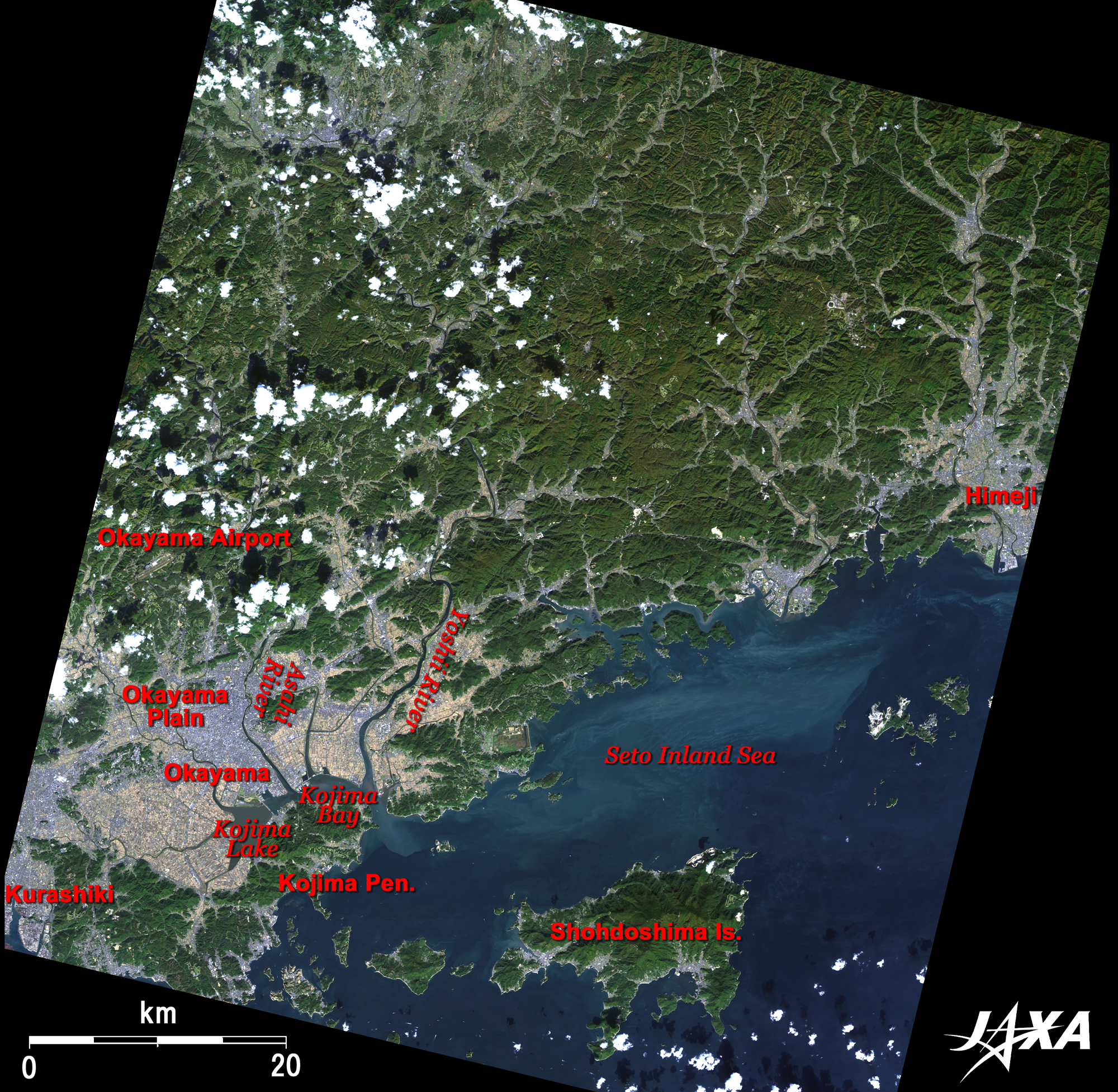
The southern part of Okayama was once a beautiful shallow sea commonly called "Kibi-no-anaumi (The deep cove of Kibi)" in the late 16th century and comprised more than 20 islands between Kojima Island (the present Kojima peninsula) and the mainland. Tidal lands were formed between the islands by actions of powerful alluviation from the Yoshii River, the Asahi River, and the Takahashi River, which made later reclamation work easier. In 1681, Kojima Island was connected to the mainland by the development of Nishi (West)-Achi New Field and Higashi (East)-Achi New Field located south of the present Kurashiki Station. Reclamation continued using alluviation from the Asahi River to obtain about 68 km2 of new land in the Edo era. After the Meiji Restoration (1868), former samurai-class people took over this project, which was followed by a national enterprise after 1946. By the end of this project in 1963, an additional 55 km2 of new land had been reclaimed. (The Takahashi River is located on the western side outside Fig. 1.) Okayama is the capital city of Okayama Prefecture and is located about 8 km upstream from the mouth of the Asahi River. Okayama Airport is visible between the mountains in northern Okayama City. Shodo-shima Island of Kagawa Prefecture at the bottom of the figure is the locale of the famous novel "Twenty-Four Eyes" by Sakae Tsuboi, which was featured two times in Japanese films and six times in Japanese TV dramas.
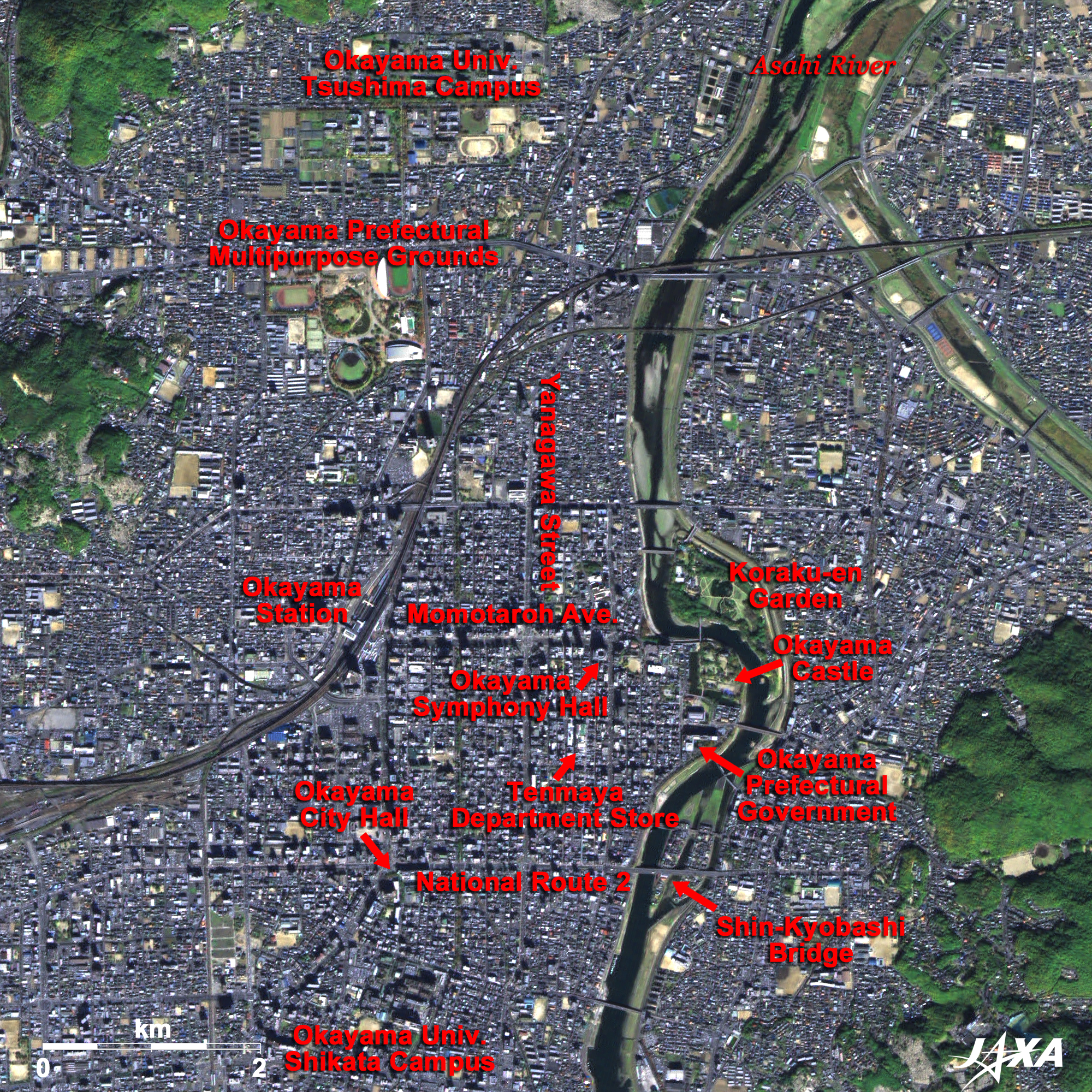
The urban area and the residential area are grey, and farmland looks like regular light-brown or yellow-green patches. The image was acquired after the harvest, and paddy fields west of Kojima Lake and north of Kojima Bay look light brown. The darker paddies are considered to be wetter than the others. Okayama Castle and Okayama Korakuen Garden are located on the banks of a small meander of Asahi River. On their west is the downtown area of Okayama City. Okayama Korakuen Garden, together with Kairakuen Garden of Mito City in Ibaraki Prefecture and Kenrokuen Garden of Kanazawa City in Ishikawa Prefecture, are feudal lords’ gardens, and they share the honor of "The Three Notable Gardens in Japan." The area along the old Sanyodo-way, starting from the western suburb of Okayama City and extending to Souja City, between the Sanyo Expressway and the Sanyo Shinkansen, is known as the "Kibiji (Kibi’s Way)" area. This area was "Kibi-no-kuni (Kibi Province)" in ancient times, which had a sphere as powerful as "Yamato-no-kuni" and "Kita (North)-Kyushu" cultural areas. Ancient burial mounds, historical sites, and cultural assets can be found everywhere, and people pass the legendary root form of the "Momotaro" story* from generation to generation. "Saidaiji Eyo" (naked festival), known as a strange festival, takes place in Saidaiji-Kan-non-in precinct (Saidai Temple’s Deity of Mercy) located on the bank of Yoshii River on the right of the figure, at night on the third Saturday of February each year.
Okayama Castle is located on the bank of Asahi River at the eastern end of Momotaro Avenue. Okayama Castle has a complex structure composed of six stories on three levels of architectural structures. The castle was completed in 1597 by Hideie Ukita, a member of the "Council of Five Elders of Toyotomi," after eight years of construction. He changed the course of the river, creating a moat to protect the northern and eastern sides of the castle keep. After Hideie Ukita was defeated at the "Battle of Sekigahara" (1600), Hideaki Kobayagawa took over the castle but died the following year and his family line ceased. Tadatsugu Ikeda entered the castle in 1603, and Okayama became Ikeda’s castle town thereafter. The dark L-shaped inner moat (Japanese: Uchibori) is visible west and south of the Okayama castle keep. At that time, there were also other inner moat, a middle moat (Nakabori), and an outer moat (Sotobori). The outer moat was called "Hatsuka-bori (Twenty-day moat)" and was built by Hideaki Kobayagawa; its remnant can be seen as Yanagawa-suji Avenue. Traces of the middle moat can be found on the streets at the western side of Tenmanya, and those of the inner moat around the external wall (Nino-maru) can be found on Holland East Street south of the Okayama Symphony Hall. Most of the streets of the castle town in the outer moat remain today and are still used, which indicates that the grand design of Okayama City was established during the castle town construction. Kourakuen Garden was landscaped by the fourth castellan Tsunamasa Ikeda in 1687 and completed in 1700. Some modifications were made by subsequent local lords, but most of its features established in the Edo era remain today. The castle town Okayama was steadily developed under the Ikeda family and became one of the ten major economic domains of the late Edo era. Okayama Prefectural Multipurpose Ground is located about 2 km north of Okayama Station. It consists of a baseball field, an athletic stadium (Momotaro Stadium), a gymnasium (Momotaro Arena), and a martial arts hall (Budokan). Located to its north is the Tsushima Campus of Okayama University; Shikata Campus is located at the bottom of this figure. Okayama City Hall is located on the southern corner of the crossing of City Hall Street extending from Okayama Station and National Route 2 from Shinkyo-bashi Bridge. Okayama, a core city with a population of 700,000, will become an ordinance-designated city on April 1, 2009, making it the 18th in Japan and the second of Chugoku-Shikoku District following Hiroshima City.
|