| |
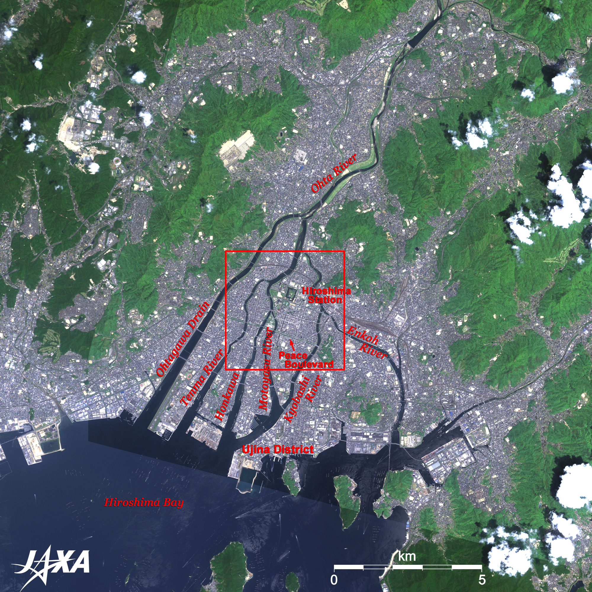
Figure 1 depicts Hiroshima and its vicinity as observed in late May 2007. The grey urban area in the center of the figure is Hiroshima City, the largest city in Chugoku district in Japan. Hiroshima developed on the deltas of Ohta-gawa (gawa or kawa means river), which originates in the Chugoku Mountains. Ohta-gawa branches off and creates five deltas at some places in the city; changes its name to Tenma-gawa, Motoyasu-gawa, Kyobashi-gawa, and Enkou-gawa; and empties into Hiroshima Bay. The westernmost artificial looking Ohta-gawa drainage canal was built for flood control. This city, fondly called "The Capital of Water," has been protected from many floods by this canal. Two green belts running parallel in the city center frame the 100m-wide Heiwa-oh-dori (Peace Avenue). This avenue runs about 4km east and west connecting five deltas. The Peace Parade of "Hiroshima Flower Festival" in May takes place here every year. Deep-blue Hiroshima Bay at the bottom of the figure is mirror-smooth, and many dotted lines of aquafarming racks of oysters (Hiroshima's specialty) are visible around the islands. Ujina port area (Hiroshima port) is the base of marine passenger traffic in Seto Inland Sea. Many white wakes of busy ferries connecting islands in the Inland Sea are also seen. Reclaimed lands along the coast are industrial area where factories of Hiroshima's leading car and heavy machinery line up in orderly fashion. The white roofs of the buildings form a beautiful geometrical pattern like a macrophotograph of a computer chip.
 |
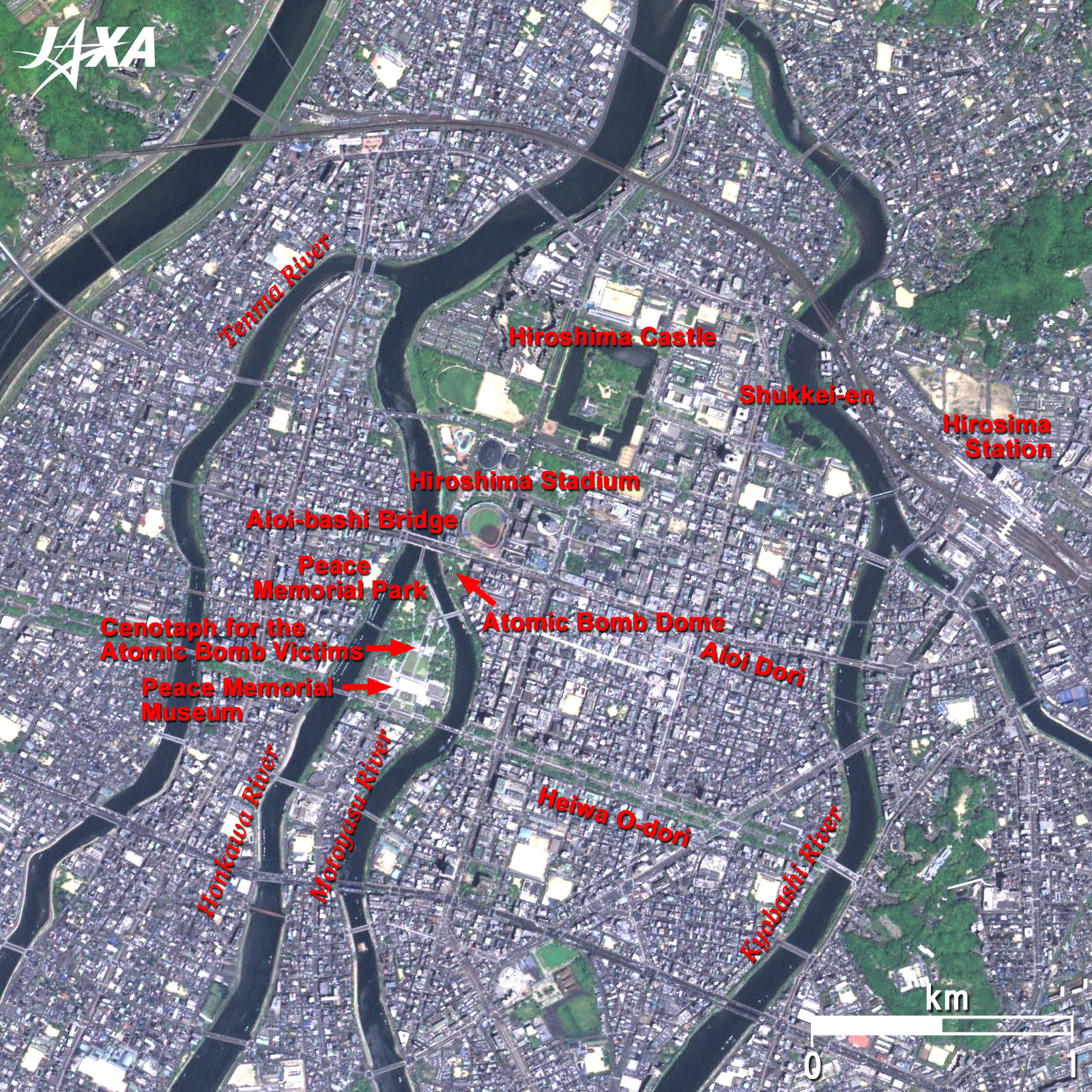
Fig. 2 Close-up of Hiroshima
Hiroshima (kmz, 2.36MB, Low Resolution) as seen on Google Earth. |
Figure 2 is a close-up of central Hiroshima. The A-Bomb Dome is barely visible as a dark-brown round lump where Motoyasu-gawa branches off. This monument still retains its shape of that day, but the building was actually the former modern Industrial Promotion Hall, originally designed by Czech architect Jan Letzel and completed in 1915. The A-bomb explosion over this building on August 6, 1945, collapsed the outer wall, but the skeletal ruin of the roof remains. Its form reminds people of the scene just after the bombing, which occurred more than 60 years ago. People visit here to pray for peace. The A-Bomb Dome was added to the list of the World Heritage sites of the United Nations Educational, Scientific and Cultural Organization (UNESCO) in December 1996 as a symbol of the people worldwide who crave for peace.
Peace Memorial Park is the green area located on the bank opposite the A-Bomb Dome across Motoyasu-gawa. The park was built to send a wish for everlasting peace in the world. Hiroshima Peace Memorial Museum in the park was designated as an important cultural asset in 2006. In the east building on the right, "Hiroshima's Ayumi" (Steps of Hiroshima) before and after the bombing is presented in pictures and models, and many materials showing the devastation caused by the bombing are exhibited in the main building on the left. The Memorial Cenotaph for the victims of the A-bomb, modeled on the house shape of Haniwa (the ancient Japanese burial mound), stands on the side of "Pond of Peace" in the center of the park. These monuments and buildings were designed by globally prominent architect Mr. Kenzo Tange.
Standing in front of the Memorial Cenotaph and looking through its delta roof, the figure standing calmly, separated from the busy town, is the A-Bomb Dome.
Hiroshima is a tourist city with over ten million visitors a year. The city has the historic atmosphere of a castle town, and streetcars in the city are a part of the cityscape. The green area extending from the Peace Memorial Park across Aioi Avenue, which runs through the busiest part of downtown Hiroshima, is also a nice visiting spot with many highlights. Hiroshima Baseball Stadium located here is the home ground of the citizen's professional baseball team "Hiroshima Toyo Carp" nicknamed "Red Helmets." A moat around the Hiroshima Castle built by the feudal load Terumoto Mori (a grandson of Motonari Mori) in the civil war period (15th-16th century) and a circuit style Shukkei-en garden landscaped in the Edo era (1603-1867), which was assigned as a national scenic beauty area, are some of the excellent sites worth visiting. The green area around the Peace Memorial Park contains relaxing visitors from all over the world and is an oasis for citizens who enjoy flowers of the seasons. Peace Memorial City Hiroshima is the birthplace of the worldwide "Nuclear Weapon Abolition Movement."
Explanation of the Images:
Figs. 1 and 2. Click the images twice to enlarge them.
PRISM is an optical sensor for observing ground surfaces with visible and near-infrared signals in the 520 to 770 nano-meter (one-billionth of a meter) band. The acquired image is monochrome. PRISM has three independent optical systems (telescopes) to acquire images for nadir, forward, and backward views at the same time. Only the nadir image was used in this article.
AVNIR-2 is equipped with a pointing function by which it can shift its observation area perpendicular to ALOS's direction of travel and has four observation bands. The composite images are usually produced by assigning red to Band 3 (610 to 690nm), green to Band 2 (520 to 600nm), and blue to Band 1 (420 to 500nm). The AVNIR-2 composite image was then transformed into hue, saturation and intensity, and the intensity was replaced by the PRISM image. The hue, saturation and intensity data were then reversed into a color image. As a result, a virtual 2.5m ground-resolution color image was obtained. This kind of high-resolution color image, composed by combining the higher-resolution monochrome image and the lower-resolution color image, is called a pan-sharpened image.
Figures 1 and 2 are high-resolution, pan-sharpened images composed this way. The resulting image has natural coloring as if seen by the naked eye. Thus, colors indicate the following ground objects.
| Khaki or brown: |
Bare ground |
| Green: |
Forests |
| Bluish grey: |
City area or roads |
| Dark Blue: |
Water surfaces |
| White: |
Clouds |
|
 |
|