| |
 |
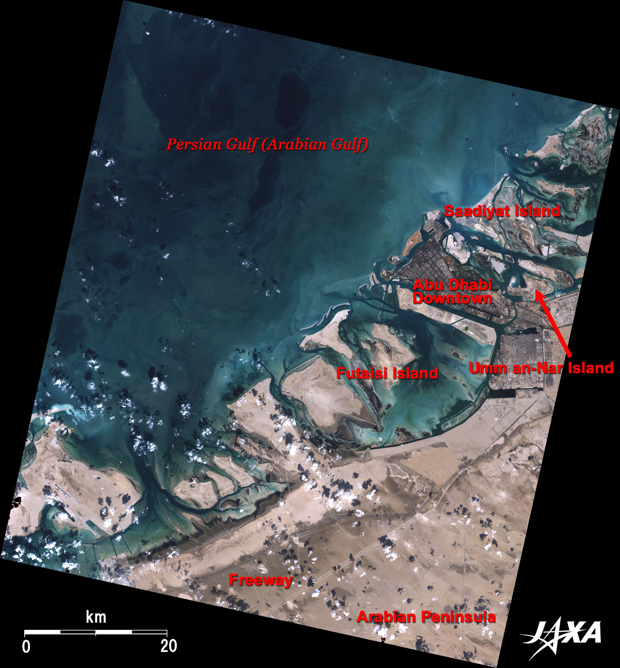
| Fig. 1. Vicinity of Abu Dhabi |
Figure 1 depicts Abu Dhabi and its vicinity as observed in November 2007. Abu Dhabi is the capital of the United Arab Emirates located in the southeastern Arabian Peninsula, which faces the Prussian blue Persian Gulf (also called Arabian Gulf) visible in the upper left of the figure. Light ocher ground in the lower right is the easternmost end of the Rub al Khali desert meaning the "Empty Quarter". Black lines slanting across the desert are freeways with roadside trees. Many large and small sand bars are also visible along the coast. Offshore oilfields of Zakum and Umm al-Dhalk are located on the western sea area of Abu Dhabi (not visible in the figure). Japanese oil companies are operating there.
The dark-brown Abu Dhabi Island in the upper right of the figure is the urban area of Abu Dhabi. The city has many green areas that look darker as they reflect less light than the sands. Since Abu Dhabi is in an arid land, it primarily uses distilled seawater to irrigate plants and supply daily water needs. The seawater desalination plant at Umm al-Nar Island in the upper right of the figure was built using Japanese technology. In order to avoid competition with Dubai, an environment and culture oriented toward ambitious tourism development is being established on the prominent white sand bars around the city. In particular, construction of a world-class cultural center, which includes many art galleries and national museums such as a branch of Louvre Museum, is on schedule on Sandiyat Island ("Happiness Island").
 |
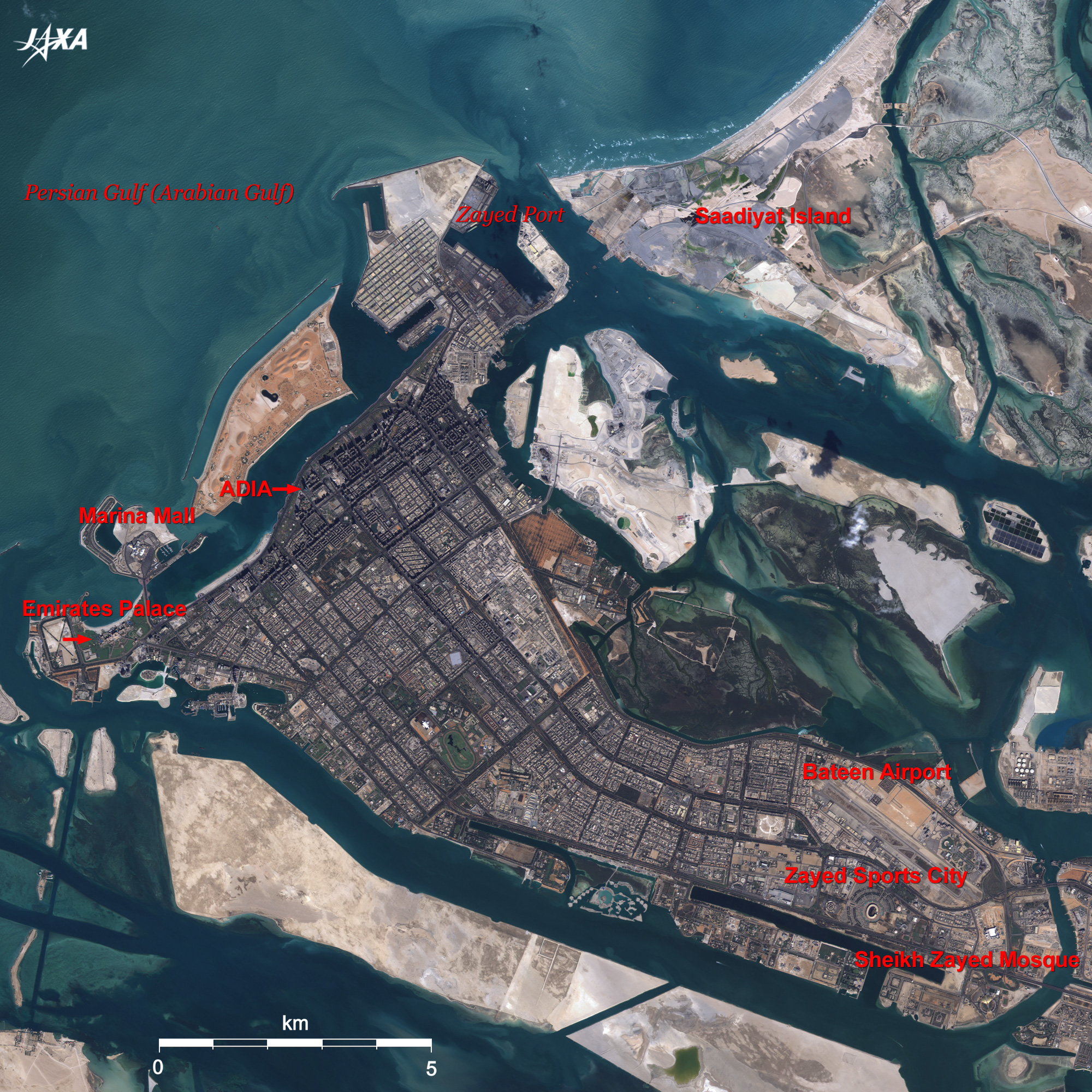
Fig. 2. Close-up Image of Abu Dhabi
Abu Dhabi (kmz, 3.85MB, Low Resolution) as seen on Google Earth. |
Figure 2 presents a close-up image of the Abu Dhabi urban area. Trunk roads extend like a grid in the city, and regularly spaced square high-rise buildings stand in rows along the boulevards. Roadside date palm trees and green parks are arranged in the urban canyons. This city presents an inorganic impression peculiar for such a new city. The cluster of high-rise buildings densely arranged according to the city plan provides a spectacular view of skyscrapers rising up from the desert when viewed from the Persian Gulf. The conspicuous streamlined building soaring beside Corniche Road is the tower building of Abu Dhabi Investment Authority (ADIA). It is known as the world’s largest governmental investment fund (estimated at about one trillion dollars), which leaped into the limelight when it declared a bail-out plan for major money and banking businesses of the United States in the recent financial crisis triggered by subprime loan problems.
The seven-star hotel, Emirates Palace, which faces the bow-shaped white beach and is surrounded by a vast garden, is visible on the left of the figure. From its elegant salmon pink appearance and luxurious interior décor, it is literally described as a hotel built like a palace. Abu Dhabi looks like a highly dense town, with city functions such as the sea-gate Zayed Port on the north of the island, The Golf and Equestrian Club with its fresh green lawn in the center of the city, Bateen Airport in the lower right, and Zayed Sports City and the world’s third largest Sheikh Zayed Mosque (which can accommodates 40,000 worshippers and is famous for the world’s largest carpet measuring 5,627m2) located near the entrance to the island.
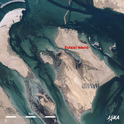 |
| Fig. 3. Futaisi Island |
Figure 3 depicts Futaisi Island located below Abu Dhabi Island. It is an environment-oriented resort island, and visitors can enjoy Arabian horse riding and wild animals. Many cottages are visible in the northern part of the island. Large letters that read "HAMAD" are visible in the southern part of the island. The first two letters "HA" are green, but the others are almost buried in the sands. Each letter measures about 500m and was written by pouring seawater onto the ground. These letters have been a hot topic on the internet since 2006 where they are known as the large mystery letters on the ground. It turns out that it was the owner's name of the island. Sometimes satellites find bizarre formations on the ground like this, which makes us enjoy being detectives by approaching the mystery from its temporal changes.
The United Arab Emirates (UAE) was born as a federated nation consisting of seven emirates having strong autonomy in 1971 after the discovery of oil in the early 1960s and withdrawal of the United Kingdom from Suez. Since its foundation, UAE has maintained close relations with Japan. It is widely known that a friendship cup resembling a traditional Arabian coffeepot and gasoline for one year are given to the winner of the national sport Sumo wrestling tournament as prizes. The UAE is an important and vital trade partner for Japan and exports 60% of its total export volume of oil to Japan.
Dubai, one of the seven emirates, has been spotlighted as a tourism-oriented country in recent years. However, Abu Dhabi is also the center of politics and economy and accounts for 80% of the area and 90% of the oil production of the UAE. It also accounts for about 10% of the world’s crude oil deposits, which are estimated to provide oil for about 100 years. Abu Dhabi, embraced by the Persian Gulf and the Rub al Khali desert, is today’s oasis city where vital energy and relaxation are offered to the people of the world through abundant oil money.
Explanation of the Images:
(Click the images twice to enlarge.)
Fig. 1
AVNIR-2 has four observation bands. Figure 1 is produced by assigning red to Band 3 (610 to 690nm), green to Band 2 (520 to 600nm), and blue to Band 1 (420 to 500nm). The resulting images have natural coloring as if seen by the naked eye. Thus, the following colors designate ground objects.
| Grey: |
City area or roads |
| Dark brown: |
Semi-moist sands |
| Ivory: |
Bare land or sands |
| Blue: |
Water surfaces |
| White: |
Clouds |
Figs. 2 and 3
PRISM is an optical sensor for observing ground surfaces with visible and near-infrared signals in the 520 to 770 nano-meter (one-billionth of a meter) band. The acquired image is monochrome. PRISM has three independent optical systems (telescopes) to acquire images for nadir, forward, and backward views at the same time. Only the nadir image was used in this article.
The above AVNIR-2 composite image was then transformed into hue, saturation and intensity, and the intensity was replaced by the PRISM image. The hue, saturation and intensity data were then reversed into a color image. As a result, a virtual 2.5-m ground-resolution color image was obtained. This kind of high-resolution color image, composed by combining the higher-resolution monochrome image and the lower-resolution color image, is called a pan-sharpened image.
|
|