| |
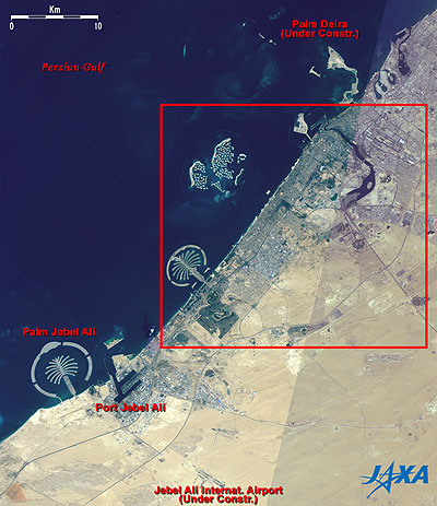 |
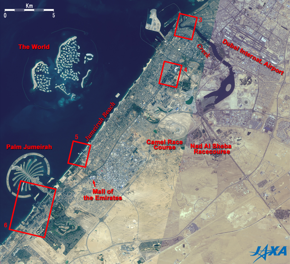
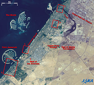
Fig. 1 Wide Area Image of Dubai
Dubai (kmz,1MB,Low Resolution) is seen from Google Earth. |
Figure 1 depicts the vicinity around Dubai, a trade, business, and resort city on the Arabian Peninsula, as observed by the Advanced Visible and Near Infrared Radiometer-2 (AVNIR-2) on board the Advanced Land Observing Satellite (ALOS) "Daichi" in December 2006 and in March 2007. The upper left half of the figure is the Persian Gulf and the lower right half is the Arabian Peninsula with the inland ocher desert. Large artificial islands are visible on the sea and there is the city area as well as green tracts including parks in the coastal area.
Dubai has been prospering thanks to the Creek, a natural canal in the upper right of the figure that has served as the transfer point of marine trade routes for over 2000 years. Present Dubai, one of the emirates that compose the United Arab Emirates (UAE) organized in December 1971, continues to develop economically based primarily on commerce and tourism. In the lower left of the figure, you can see the artificial island Palm Jebel Ali, a resort facility now under construction; the world's largest artificial port, Jebel Ali, which incorporates a free-trade zone; and the Jebel Ali International Airport which is currently under construction and which will be used for freight after partial completion in 2008. Part of Palm Deira, where construction has begun on the third palm island, is visible in the upper right of the figure.
 |
| Fig. 2 Central Dubai |
Figure 2 is an expanded image of the area within the red frame in Fig. 1. Palm Jumeirah, which was the first palm island to be developed, can be seen on the sea in the lower left of the figure. The form is literally copied from the palm tree and consists of a trunk, a crown with 17 fronds, and the arc-shaped islands functioning as the breakwater. The whole width is about 5km, and luxurious hotels, villas, and apartment buildings are under construction. Another artificial island, "the World," patterned after a world map, is visible on the north side of the islands. The breakwater was constructed in the shape of an ellipse with a 9km major axis and a 6km minor axis, and some 300 large and small islands are being constructed as the infrastructure develops.
The Creek and the Dubai International Airport can be seen in the upper right of the figure. Deep within the Creek is a wildlife sanctuary.
A camel race course and the Nad Al Sheba Racecourse can be seen at the center of the figure.
The green tracts in the coastal area include parks and golf courses. Inside and around red frames 4 and 6 you can see many small shadows extending to the upper left, indicating numerous skyscrapers.
A huge leisure and shopping facility called the "Mall of the Emirates" is visible in the lower left of the figure and contains an indoor ski resort.
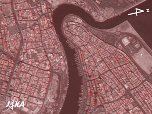 |
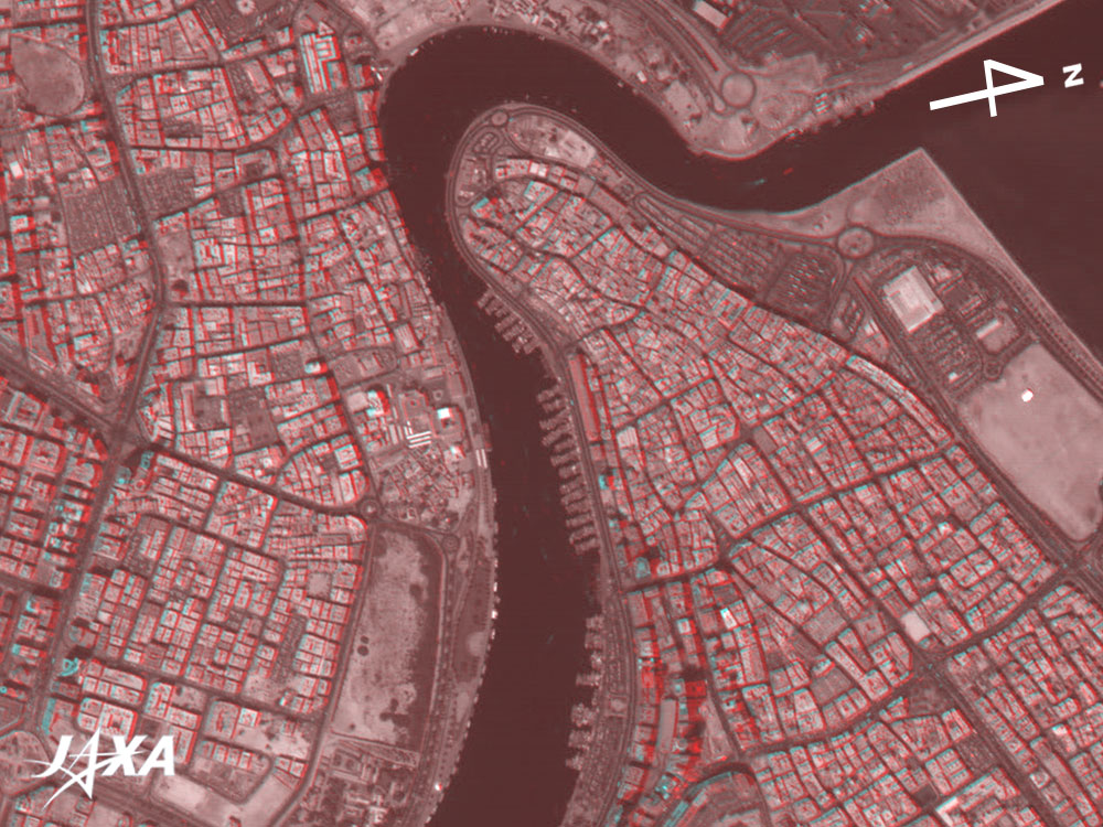
Fig. 3 Three-Dimensional View near the Mouth of the Creek
(Staring at the image for a long time may cause eye-strain. A color print is available in pdf format. Pdf files for the left and right eyes are also available for stereoscopic viewing.) |
Figures 3 to 6 are 3-D views combining nadir- and backward-looking images from the three directional images captured by the Panchromatic Remote-sensing Instrument for Stereo Mapping (PRISM) in March 2007. They correspond to the area within red frames 3 to 6 in Fig. 2. The black band at the center of Fig. 3 is the Creek. On the right bank of the Creek is Deira, and on the left bank is Bur Dubai. There are also several traditional markets called Souk. The many wharfs on the right bank of the Creek look like the teeth of a comb. If you view the image using the red and blue glasses, you can clearly see that the Deira area on the right bank of the Creek takes on the form of a marine terrace.
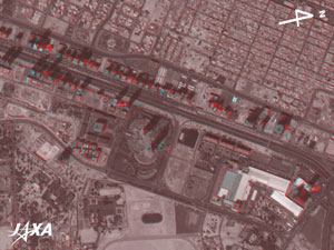 |
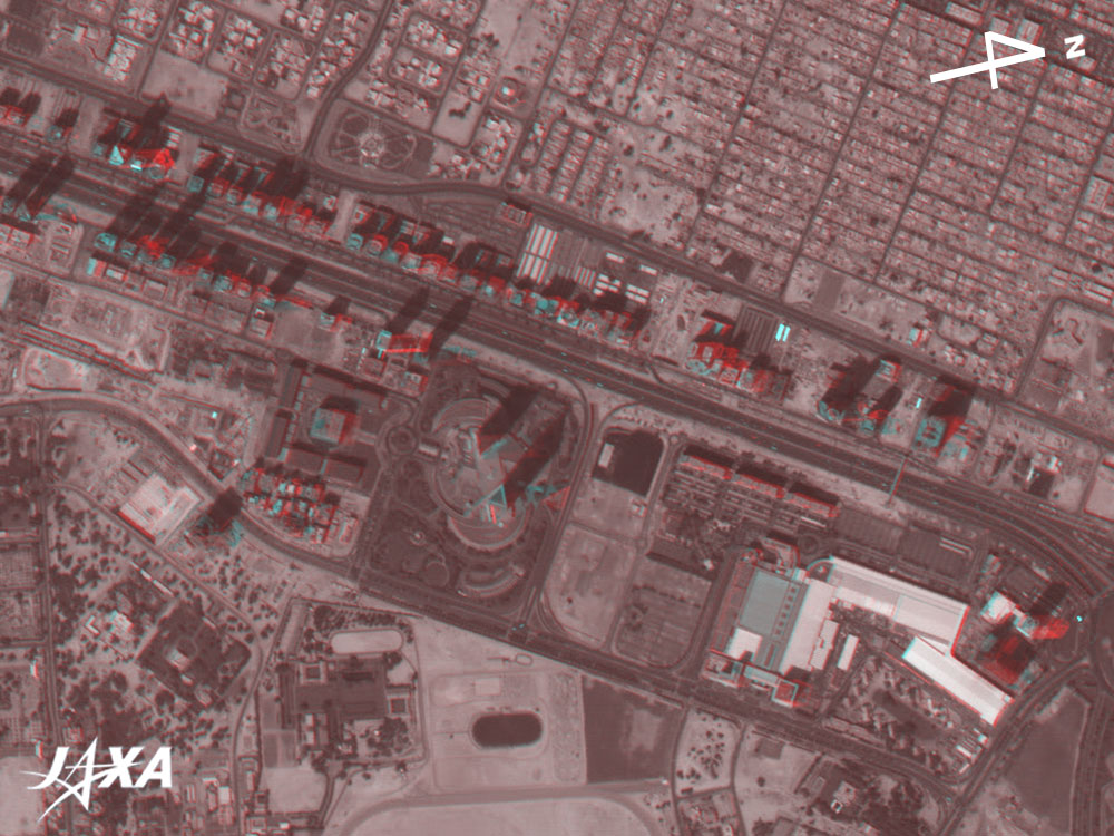
Fig. 4 Three-Dimensional View of Satwa area
(Staring at the image for a long time may cause eye-strain. A color print is available in pdf format. Pdf files for the left and right eyes are also available for stereoscopic viewing.) |
You can find the Sheikh Zayed Road in the center of the figure, and many high-rise hotels and office buildings line both sides of the road. The two skyscrapers in the center of the figure are the Emirate Towers, and Dubai World Trade Center can be seen in the lower right.
 |
Fig. 5 Three-Dimensional View of Jumeirah Beach (Part 1)
(Staring at the image for a long time may cause eye-strain. A color print is available in pdf format. Pdf files for the left and right eyes are also available for stereoscopic viewing.) |
A large, strangely shaped hotel appears to float on the sea in the center of the figure. Stretching up 321m, it is the world's tallest hotel building and was designed in the form of the sail of a "dhow," a sailing vessel for inshore trade that is used even now on the Indian Ocean and the Arabian Sea. A marina and a wave-shaped hotel can be seen in the lower right.
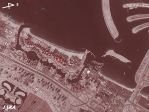 |
Fig. 6 Three-Dimensional View of Jumeirah Beach (Part 2)
(Staring at the image for a long time may cause eye-strain. A color print is available in pdf format. Pdf files for the left and right eyes are also available for stereoscopic viewing.) |
Part of Palm Jumeirah can be seen in the upper right of the figure, and a park shaped like a human pelvis is visible in the lower left. Jumeirah Beach Residence, consisting of 36 skyscrapers for condominiums and four for hotels can be seen on the seaside of the artificial canal, and Jumeirah Lake Towers, including more than 30 skyscrapers for condominiums, is visible on the land side of the Sheikh Zayed Road.
If you view the sea without red and blue glasses, you will see the light-blue and red wakes of ships. The red image is the backward-looking image, and the light-blue image, the nadir-looking image. Because the backward-looking image is acquired about 45 seconds after the nadir-looking image, the red wakes appear in positions about 45 seconds after the light-blue wakes.
Reference:
Makishima Kimi, Cool Dubai! (in Japanese), San-ichi Shobo, 2006
Referenced site:
 How to make red and blue glasses (cf. Appendix of "Three-Dimensional View of Mt. Haruna") How to make red and blue glasses (cf. Appendix of "Three-Dimensional View of Mt. Haruna")
|
Explanation of the Images:
Figs. 1 and 2
AVNIR-2 has four observation bands. Figures 1 and 2 were produced by assigning red to Band 3 (610 to 690nm), green to Band 2 (520 to 600nm), and blue to Band 1 (420 to 500nm). The resulting image has natural coloring as if seen by the naked eye. Thus deep sea looks dark blue; shallow water, light blue; parks, golf courses, farmlands, etc. green; roads and buildings, grey; and exposed rocks and soil, brownish.
There are some color tone differences between the right and left sides of Figs. 1 and 2.
This seems due to the atmospheric conditions and seasonal vegetation differences at the time of observation.
Figs. 3 to 6
PRISM is an optical sensor for observing ground surfaces with visible and near-infrared signals in the 520 to 770 nanometer (one-billionth of a meter) band. PRISM has three independent optical systems (telescopes) to acquire images for nadir, forward, and backward views at the same time. The acquired image is monochrome.
The nadir image (green and blue) and the backward image (red) were used in Figs. 3 to 6.
Parallax, the difference between the viewing angle of the image as seen with the right and left eyes, is utilized in order to view the three dimensional image. In Figs. 3 to 6, the left side is the satellite moving direction, and the right, nearly to the north because the backward image of the satellite is seen with the left eye and the nadir image with the right eye. Note that upward is north in Figs. 1 and 2, whereas right is north in Figs. 3 to 6. |
 |
|