Seen from Space 2008
The 40th anniversary, Ogasawara Islands
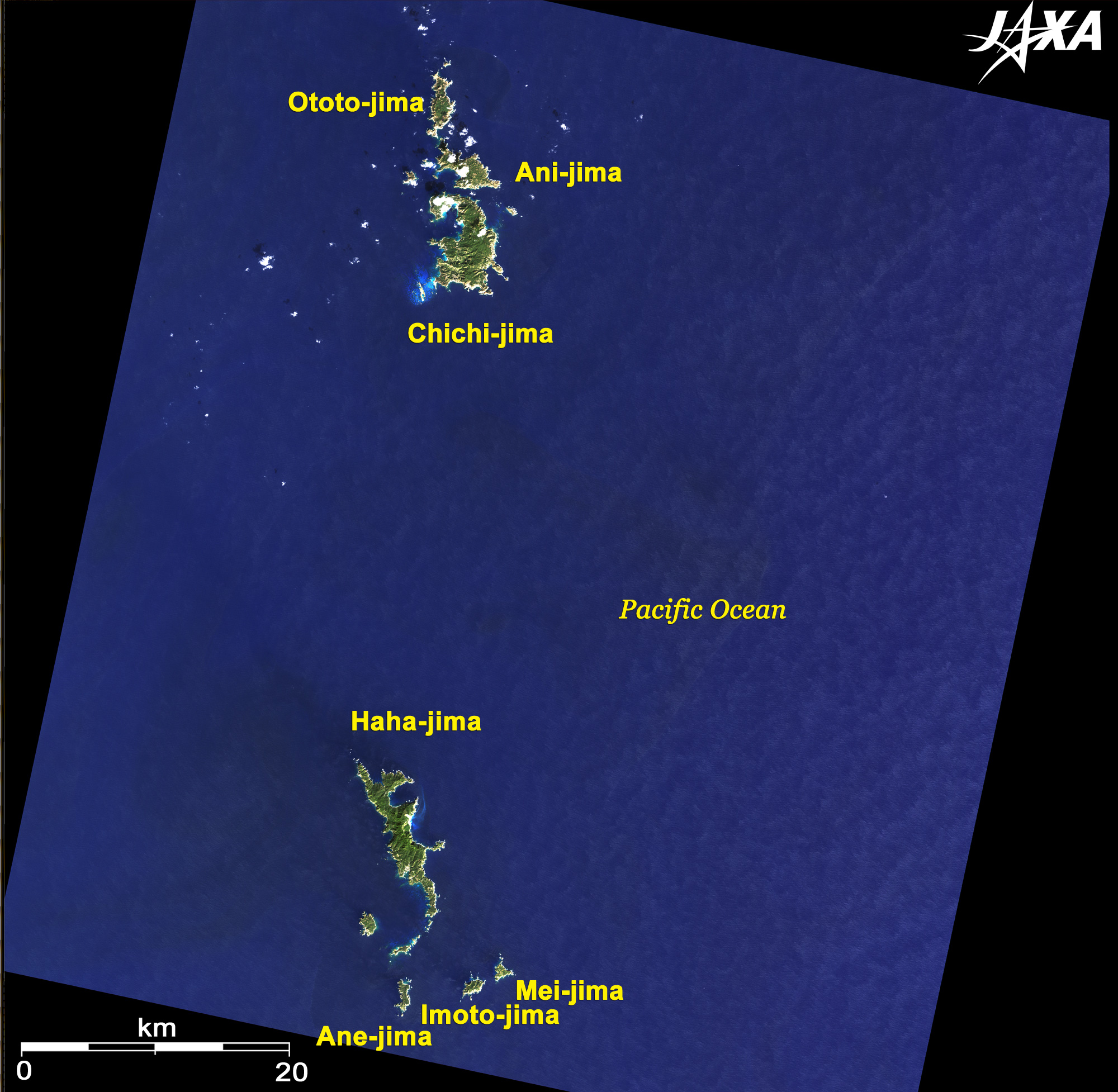
The Ogasawara Islands are 1,000km southeast of Tokyo, Japan. They are oceanic islands and volcanic islands like Hawaii and the Galapagos Islands. The Ogasawara Islands have unique ecosystems because they have been isolated from all continents since their formation. Most of the Ogasawara Islands were designated a Japanese National Park in 1972. They are now tentatively listed on the World Heritage list of the United Nations Educational, Scientific and Cultural Organization (UNESCO), and around these islands humpback whale watching can be enjoyed in spring. The Pacific Plate was overridden by the Philippine Plate 48 to 45 million years ago, and the Muko-jima Islands and the Ogasawara islands were formed by the subsequent volcanic activity in the shallow layer. As the volcanic activity moved south, the Haha-jima Islands were formed by the activity in the deeper layer. With further subduction of the Pacific plate, the volcanic islands including Iou-jima were formed and are still active today. The volcanic islands are located 180km southwest of this image. Except for Chichi-jima, Haha-jima, and Minami-tori-shima, the islands are uninhabited. Ogasawara has a population of 2,700 (National Census, 2005) and is part of the Tokyo megalopolis.
The beautiful beach visible from offshore Ani-jima extends from Miyanohama on the northern end of Chichi-jima to Nagasaki and Hatsuneura. The sea is home to coral reefs and tropical fish. JAXA's tracking station in the center of the island monitors the flights of rockets launched from Tanegashima Space Center. On a clear day, you can see all around as far as Muko-jima and Haha-jima from Mt. Chuo (central Chichi-jima, 319m above sea level) south of the station. Kopepe beach and Kominato beach on the west of the island are beautiful white beaches where sea turtles lay their eggs. Boarding houses and bed-and-breakfast facilities dot Nogiyama, Ohgiura and Kominato beaches. Minami-jima (South Island) on the southwestern end of Chichi-jima is a natural treasure island in the Ogasawara Islands. Sightseeing and trekking tours for viewing various flora and egg-laying sites of sea birds and sea turtles are very popular. However, landing on the island is limited to protect the natural environment.
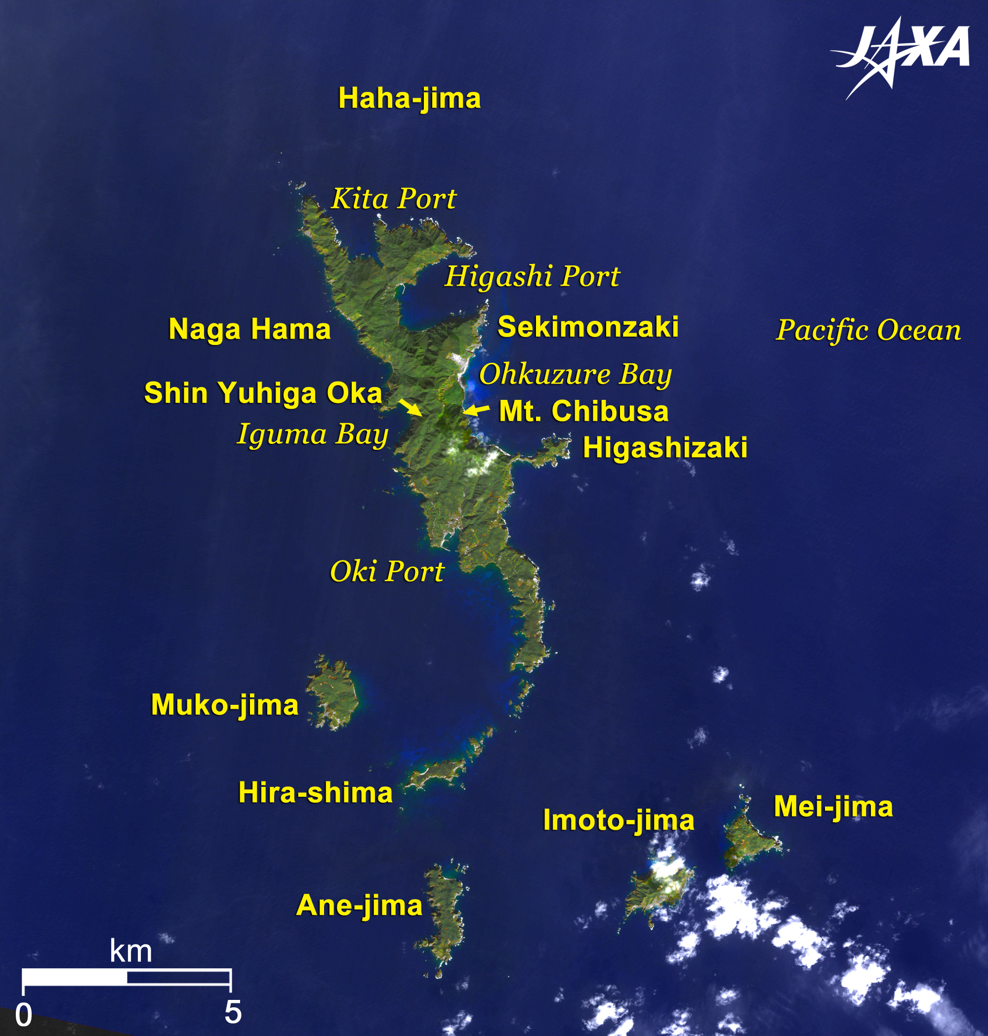
Several hundred people lived in North Port on the north side of Haha-jima before World War II. A coral reef protects the island, and blue sea turtles inhabit the surrounding sea. The highest peak on Haha-jima is Mt. Chibusa (463m above sea level), and other mountains rise from the center of Haha-jima. Many plants are indigenous to Ogasawara, such as Hahajimanobotan (a type of peony) and wadannoki (wild chrysanthemum). The east beach visible from the mountain top is beautiful, as is the sunset from Shin-yuhi-ga-oka near Inokuma Bay. The present island population is concentrated in Motoji (Okimura and Fujisawa) facing Port Oki south of the island. Ane-jima, Imoto-jima and Mei-jima are now uninhabited and have become the habitat of native fauna and flora, including the bird "Meguro" (Bonin Honeyeater), a special Natural Treasure of Japan. Ogasawara has a complicated history due to its geography but has transitioned from comeback and restoration to development and enrichment. New cultural activities, such as the hula dancing of and other dances of South Pacific cultures have now become popular. Memorial ceremonies and carnivals are planned for the 40th anniversary, so please visit Ogasawara.
Figs. 2 and 3 PRISM is an optical sensor for observing ground surfaces with visible and near-infrared signals in the 520 to 770 nano-meter (one-billionth of a meter) band. The acquired image is monochrome. PRISM has three independent optical systems (telescopes) to acquire images for nadir, forward, and backward views at the same time. Only the nadir image was used in this article. The AVNIR-2 composite image was then transformed into hue, saturation and intensity, and the intensity was replaced by the PRISM image. The hue, saturation and intensity data were then reversed into a color image, resulting in a virtual 2.5m ground-resolution color image. This kind of high-resolution color image, composed by combining a higher-resolution monochrome image and a lower-resolution color image, is called a pan-sharpened image.
|