ページの先頭です。
本文へジャンプする。
【Important Notices】This page is an archive page of information published in the past. Since the update has been completed, it may contain broken links or outdated information. For the latest information, please use the new site Earth-graphy (earth.jaxa.jp).
ここからサイト内共通メニューです。
サイト内共通メニューを読み飛ばす。
サイト内共通メニューここまで。
ここから本文です。

Seen from Space 2006

Observing the New Year's First Sun Rising over the Ocean

 
Nosappu-misaki Inubo-saki Daio-zaki Gamoda-misaki Toi-misaki Yonaguni-jima Ogasawara-shoto
With the arrival of 2006, we have chosen spots in Japan for observing the New Year's sunrise over the ocean as our theme. The map depicts the Japanese Archipelago as seen from space 1,900 km above the ocean to the south of Japan. Click on circles A to G in the figure to see an expanded image of areas where you can see the New Year's Day sun rising from the sea horizon. All of the expanded images are 40 km wide east to west.

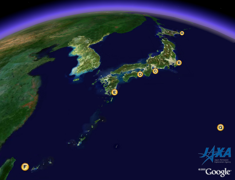
From Chichi-jima and Haha-jima in the Ogasawara-shoto area (Frame G), you can see the earliest sunrise in generally habitable regions of Japan. Chichi-jima is located about 1,000 km south of Tokyo, and Haha-jima is situated about 50 km south of Chichi-jima. They are sometimes called the "Galapagos of the Orient" because there are many animals and plants there that are endemic to only that area.

Inubo-saki in Chiba Prefecture in Frame B is where you can see the next earliest New Year's sunrise in Japan (except for the heights and isolated islands). A large stratum exposed in the Cretaceous Period in Byobuga-ura to the west of Inubo-saki has caused the area to be called the "Dover of the Orient." The mouth of the Tonegawa River on the northern side of Inubo-saki has the largest basin in Japan. Sawara and Itako to the west-northwest of Inubo-saki are riverside districts. Sawara is the home town of Tadataka Ino who created Dai-Nippon-Enkai-Yochi-Zen-Zu (Complete Japan shoreline Chart) about 200 years ago. There are two famous shrines there, Katori-jingu in Sawara and Kashima-jingu in Kashima to the east of Itako. You can see Kashima Port, an artificial port built by digging and dredging from 1965 to 1979.

From Nosappu-misaki in Hokkaido (Frame A), you can see the earliest sunrise in Hokkaido and Tohoku (except for the Northern Territories and higher elevations). Lake Furen and Lake Onneto at the base of the Nemuro Peninsula are frozen over at this time of year.

The earliest New Year's sunrise in the Kinki district can be seen from Daio-zaki in Mie Prefecture (Frame C). Daio-zaki is located on the south-east end of Shima Peninsula; its circumferential area is designated as the Ise-Shima National Park. Frame C also depicts Ago Bay, famous for pearl culturing, and the Shima Spanish Village near Daio-zaki. Toba City to the north is the location of Shinju-jima (Pearl Island) where, in 1893, Kokichi Mikimoto succeeded in culturing pearls for the first time in the world. Ise-jingu is located west of Toba City and is separated into two parts, Naiku (the Inner Shrine) and Geku (the Outer Shrine). Between Ise and Toba there is Meoto-iwa (husband and wife rocks), often featured on New Year's TV programs.

The earliest New Year's sunrise in the Chugoku and Shikoku districts can be seen from Gamoda-misaki in Tokushima Prefecture (Frame D). Gamoda-misaki is known as the spawning place of the loggerhead sea turtle. You can see the Yoshino River and Tokushima, which is famous for the Awa Odori dance, to the north of Gamoda-misaki. You can also see the Oh-Naruto-kyo Bridge that links Shikoku and Awaji-shima farther north.

The earliest New Year's sunrise in Kyushu can be seen from Toi-misaki in Miyazaki Prefecture (Frame E). Toi-misaki is located on the Southernmost Point of the Nichinan Coast Quasi National Park and is home to about 100 "Toi wild horses," that is a kind of natural treasures. Oni-no-Sentakuita (Devil's washboard; a wavelike rock) is also a natural treasure to the north of the Nichinan Coast. Udo-jingu and Aburatsu Harbor, which have prospered since the 14th century, can be seen in the middle of the Nichinan Coast.

The latest New Year's sunrise in Japan occurs in Yonaguni-jima, Okinawa Prefecture (Frame F). The world's largest moth dubbed "Yonaguni-san" (another natural treasure) inhabits this area. On the eastern end of the island is Agari-zaki, and on the western end is Iri-zaki, which is the westernmost tip of Japan.

The following table lists these New Year's sunrise observation points with their times, remarks, and other detailed information.

  New Year's Sunrise observation points Height Location New
Year's
Sunrise
Time
Remarks
A Nosappu-misaki - Nemuro City, Hokkaido 6:49 The earliest New Year's sunrise in Hokkaido and Tohoku except for higher elevations and the Northern Territories
- Zao 1,841 m The border between Yamagata Prefecture and Miyagi Prefecture 6:46 The earliest New Year's sunrise in Hokkaido and Tohoku except for the Northern Territories
B Inubo-saki - Choshi City, Chiba Prefecture 6:46 The earliest New Year's sunrise in Japan except for higher elevations and isolated islands.
- Mt. Fuji 3,776 m Border between Shizuoka Prefecture and Yamanashi Prefecture 6:42 Earlier New Year's sunrise than in Inubo-saki above
C Daio-zaki - Shima City, Mie Prefecture 6:58 The New Year's earliest sunrise in the Kinki-district
D Gamoda-misaki - Anan City, Tokushima Prefecture 7:05 The earliest New Year's sunrise in Chugoku and Shikoku
E Toi-misaki 255 m Kushima City, Miyazaki Prefecture 7:11 The earliest New Year's sunrise in Kyushu
F Yonaguni-jima - Yonaguni-cho, Yaeyama-gun, Okinawa Prefecture 7:32 The latest New Year's sunrise in Japan
G Ogasawara
-shoto
 Chichi-jima
 (Mt. Yoake)
 Haha-jima
 (Mt. Chibusa)
308 m
423 m
Ogasawara-mura, Ogasawara-shicho,Tokyo 6:17
6:16
The earliest New Year's sunrise in habitable Japan
- Minami-
tori-shima
(Marcus Island)
- Ogasawara-mura, Ogasawara-shicho,Tokyo 5:27 The earliest New Year's sunrise in an inhabited area of Japan.
Note:Where the height is not specified, the time shown is the time the sun rises over the horizon viewed from a point five meters above sea level.

JAXA will launch the Advanced Land Observing Satellite (ALOS) in the near future. It will carry the Advanced Visible and Near Infrared Radiometer 2 (AVNIR-2), which has a 10 m ground resolution. At that time, we will be able to distribute clearer images.


Reference site:
The sunrise time on New Year's Day of 2006 at various locations in Japan (Japan Coast Guard) (in Japanese)

Explanation of the images:
Figure
Satellite: Landsat -5 and -7 (USA)
Sensor: TM (USA) and ETM+ (USA)
Date: 1997 to 2002
The color was composed using three of the 30 m resolution bands: visible (630 to 690 nm, band 3) for red, visible (520 to 600 nm, band 2) for green, and visible (450 to 520 nm, band 1) for blue. As a result, the figures have a true coloring and appear as though seen with the naked eye. Snow, ice and clouds look white or gray; vegetation is green; soil and sparse vegetation are brown, and water is black. The major sea area is masked with thick blue.

Frames A to C, E and G
Satellite: Advanced Earth Observing Satellite (ADEOS)
Sensor: Advanced Visible and Near-Infrared Radiometer (AVNIR)
Date: January 24, 1997 (Frame A)
January 20, 1997 (Frame B)
January 23, 1997 (Frame C)
January 17, 1997 (Frame E)
December 14, 1996 (Frame G)
Ground resolution: 16 m
Map projectio: Universal Transversal Mercator (UTM)
The color was composed using three of the four AVNIR bands: visible (610 to 690 nm, band 3) for red, near infrared (760 to 890 nm, band 4) for green, and visible (520 to 600 nm, band 2) for blue. As a result, the figures have a natural coloring with vegetation slightly emphasized. You can interpret these images as follows.
Green:Forests or grasslands
Grayish purple:City areas
Ocher:Exposed soil or rocks
White:Buildings, snow or clouds
Dark purple:Water surfaces
Black:Water surfaces, deep shade, or no data

Frames D and F
Satellite: Japanese Earth Resources Satellite -1 (JERS-1)
Sensor: Visible and Near Infrared Radiometer (VNIR)
Date: April 4, 1998 (Frame D)
February 13, 1993 (Frame F)
Ground resolution: 18.3 m x 24.2 m
Map projectio: Universal Transversal Mercator (UTM)
Frames D and F were produced by assigning red to the visible channel (630 to 690 nm), green to the near-infrared channel (760 to 860 nm), and blue to the visible channel (520 to 600 nm). The resulting figures have natural coloring the same as the above-mentioned AVNIR images.

Related Sites:
Winter Scenery in East Hokkaido: Drift ice and a lattice-shaped windbreak forest “Great Green Grid”
London: The Capital without fog

本文ここまで。
image:Satellite Navigator
image:Satellite Applications and Operations Center(SAOC)
Earth Data Collection by JAXA Satellites
image:ページTOP