| |
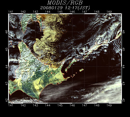 |
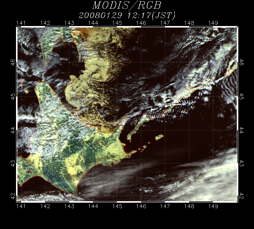
| Fig. 1 Sea-Ice Distribution in the Sea of Okhotsk on Jan. 29, 2007 (MODIS) |
Sea-ice season on the coast of Hokkaido in the Sea of Okhotsk is coming again this year. Figure 1 depicts the sea-ice distribution in the Southern Sea of Okhotsk as observed by the MODIS on January 29, 2008. You can see brown sea ice extending over a wide area from Shiretoko Peninsula to Monbetsu-city below the white clouds. You can distinguish the sea ice and clouds because the sea ice is emphasized to appear browner and clouds are emphasized to appear whiter. Note that actual sea-ice is not brown, but white.
The Japan Meteorological Agency web site (Japanese Only) announced that the first sea ice of the season was observed on January 19 and that the first arrival of sea ice in the season was observed on January 26 in Abashiri-city. The first sea ice was observed on January 19 and the first arrival of sea ice was observed on January 25 in Monbetsu-city*1 too. In Abashiri-city, the first sea ice was usual, but the first arrival of sea ice was six days earlier than usual and the earliest in the last five years.
 |
 |
 |
 |
 |
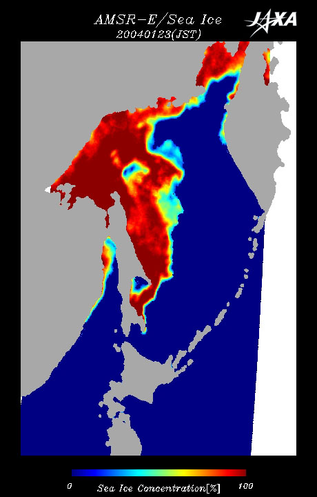
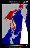
| Fig. 2 Jan. 23, 2004 |
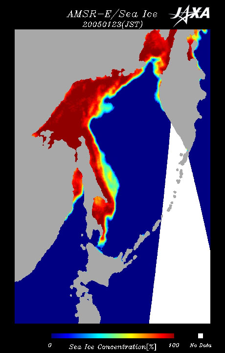
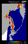
Fig. 3 Jan. 23, 2005 |
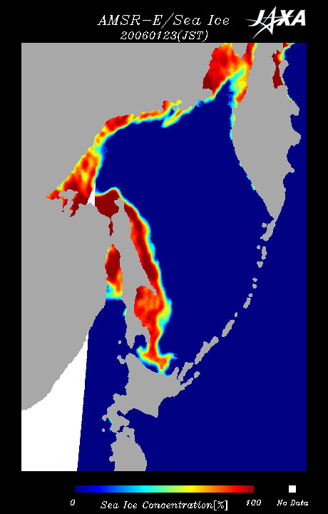
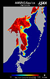
Fig. 4 Jan. 23, 2006 |
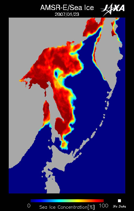
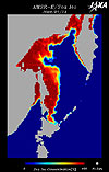
Fig. 5 Jan. 23, 2007 |
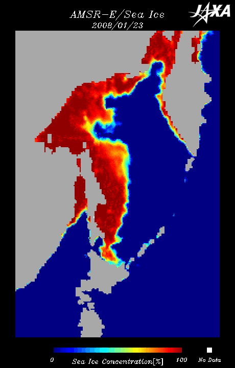
Fig. 6 Jan. 23, 2008 |
Sea-Ice Distribution in the Sea of Okhotsk (Aqua/AMSR-E)
Dec. 4, 2007 to Jan. 29, 2008 Animation (GIF, 1.7MB) |
This "Seen from Space" compares the sea-ice distribution on January 23, 2004, 2005, 2006, 2007, and 2008 (Figs. 2 to 6). You can see that the sea-ice distribution this year (Jan. 23, 2008) is the earliest southern extension to Hokkaido in the last four years. You can also see that the sea-ice distribution near Hokkaido is similar to that of other years and that the first arrival of sea ice in the year 2007 was fourth latest on record in Abashiri-city.
The latest information on the sea ice extending to the Sea of Okhotsk is released on EORC's homepage " Sea-Ice Distribution in the Sea of Okhotsk." The sea-ice distribution in the Sea of Okhotsk and detailed sea-ice images approaching the coast of Hokkaido are updated daily. The sea-ice distribution progress can also be viewed as a movie. Please visit our homepage.
The Intergovernmental Panel on Climate Change (IPCC) Fourth Assessment Report published last year forecasts that the area of sea ice will decrease in the future. The Arctic sea-ice area was obviously the smallest on record last year. There is no day recently that we do not hear news regarding global warming.
Satellite data confirm that sea ice in the Sea of Okhotsk has decreased slowly over the last 30 years.*2 Sea ice continued to decrease rapidly from 2000 to 2006. Surprisingly, however, an increase of sea ice was observed last year (Fig. 5) and this year (Fig. 6). You can see that the sea-ice never decreases monotonically. It is not clear why such fluctuation occurs, although causal relations of El Niño and La Niña on the equator and changes of sea ice around the North Pole have been investigated and researched
The Sea of Okhotsk is the lowest frozen sea in latitude of all the seas in the world. The increase and decrease of the sea-ice extent is closely related to the climate. JAXA continues to observe small signs of global warming by a satellite-borne microwave scanning radiometer night and day and regardless of weather.
Explanation of the Images:
Fig. 1 (Click the image twice to enlarge it.)
| Satellite: |
EOS- Terra (NASA) |
| Sensor: |
MODIS (NASA) |
| Date: |
January 29, 2008 |
The color composition was made by using 3 of 36 MODIS channels: channel 4 (545 to 565nm in the green band) for red, channel 2 (841 to 876nm in the near infrared band) for green, and channel 5 (1230 to 1250nm in the shortwave length infrared band) for blue. As a result, you can distinguish the light orange sea ice from the white clouds. The resolution of the original figure is 500m.
Figs. 2 to 6 and animation (Click the images twice to enlarge them.)
These figures present the sea-ice concentration calculated based on the algorithm developed by Dr. Josefino C. Comiso from NASA GSFC, one of the Principal Investigators (PIs) for AMSR/AMSR-E algorithm development, by using 36.5GHz horizontally and vertically polarized data and 18.7GHz horizontally and vertically polarized data from the six observational frequencies of AMSR-E. The above images present the sea-ice concentration estimated from the data acquired by AMSR-E. Sea-ice concentration is the ratio of ice cover per unit area. Zero percent indicates open water, and 100% indicates total sea-ice coverage. Areas with a low sea-ice concentration are light blue and change to yellow and orange for higher concentrations, with the highest sea-ice concentration displayed in red or deep vermilion. The land is gray, the open water surface (sea surface) is deep blue, and areas with no data are white. The spatial resolution is approximately 15km. |
|