Seen from Space 2006
Harbor City, Yokohama: From the time of cultural enlightenment to "Minato Mirai 21"
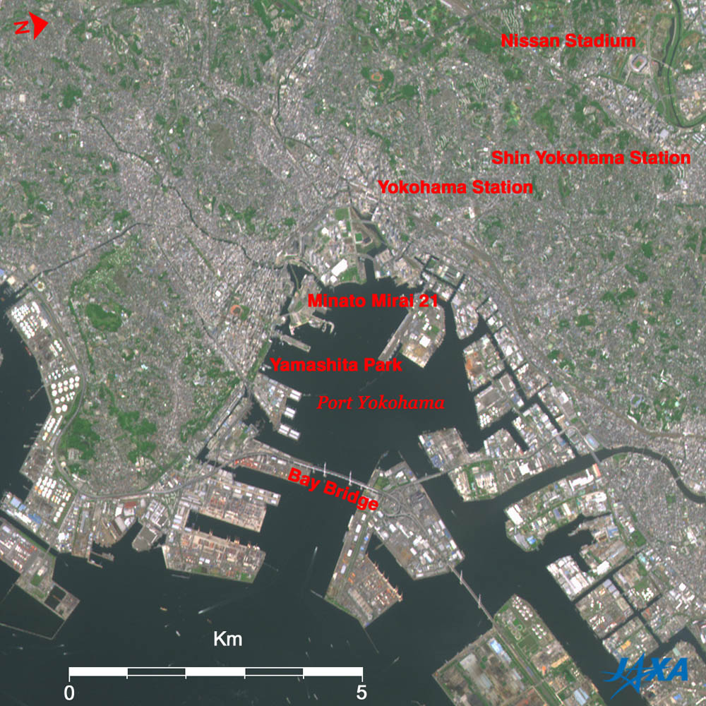
The center of the figure is the Port of Yokohama and Tokyo Bay is on the east side (at the bottom of the figure). There are the container terminals between the Port of Yokohama and Tokyo Bay. The sea surface is black, and ship wakes look white. The mouth of Tsurumi River and a cluster of factories are visible in the lower right, and white oil refinery tanks can be seen on the lower left. Several green patches such as Sankei-en Garden, now celebrating its opening centennial, and Negishi Forest Park on the former horse race track site where Japan's first western-style horse race took place are visible in the left. The upper portion of the figure with dotted green tracts of land contains residential areas. Since this is a 41° west oblique bottom image from the satellite, walls of high-rise buildings produce a stereoscopic image. The redevelopment project in Yokohama City's center and waterfront area, known popularly as "Minato Mirai 21," is just getting underway in the west (upper part of image) of the Port of Yokohama. High-rise buildings such as the Landmark Tower and the yacht-sail-shaped Inter-Continental Hotel are visible. The large bridge suspended over the Port entrance is the Yokohama Bay Bridge, which forms a part of the Metropolitan Highway Coastal Line and comprises an important distribution route of commodities to and from the Port of Yokohama. The 860m long Bay Bridge is a cable-stayed bridge suspended on wire cables stayed diagonally directly from the tower to the bridge girders. The two main towers, which rise 175m above the sea, can be seen in the figure. The Port of Yokohama is one of the two major trading ports in Japan (the other being Kobe), so foreign ships arrive and depart quite frequently. The bridge height of 55m from the sea surface was chosen so that the luxurious passenger liner Queen Elizabeth II (53m high) could enter Yokohama International Passenger Terminal "Osambashi." Yokohama provides the essential components of Japan's leading Keihin Industrial Area, in which the Port is the pivot, in the southwest of capital Tokyo with the good harbor facing Tokyo Bay. All the shorelines in the image are reclaimed land, and regularly spaced white buildings form a huge industrial complex. In the center of "Harbor City Yokohama," tourists can enjoy our many rich heritages, including cultural enlightenment, an exotic harbor atmosphere, and buildings and monuments that remind us of the days when the port was opened to the world. Around the Yamashita Park in the southeast (lower left in the image) of "Minato Mirai" district, the foreign cemetery, Yokohama Stadium, Motomachi (downtown), Chinatown, and Hikawa-maru (a retired passenger liner) are also visible. Shin-Yokohama railroad station and Nissan Stadium are located on the upper right. Nissan Stadium, formerly called Yokohama International Stadium, was constructed from January of Heisei 6th year (1994) to October of Heisei 9th year (1997) as part of the "Tsurumi River Multi-Purpose Drainage Basin" project conducted by the Ministry of Land Infrastructure and Transport (Ministry of Construction at that time). This is the core facility of the Yokohama General Athletic Park construction project conducted by Yokohama City. It is not hard to remember that the final match of "FIFA World Cup 2002" was held here. Yokohama, the capital city of Kanagawa Prefecture, population 3.6 million (as of July 1, 2006), is the largest city in Japan, except for Tokyo's 23 special wards having a population of 8.5 million.
|
|||||||||||||||||||||||||||||