Seen from Space 2007
Prince Edward Island: Home of "Anne of Green Gables"
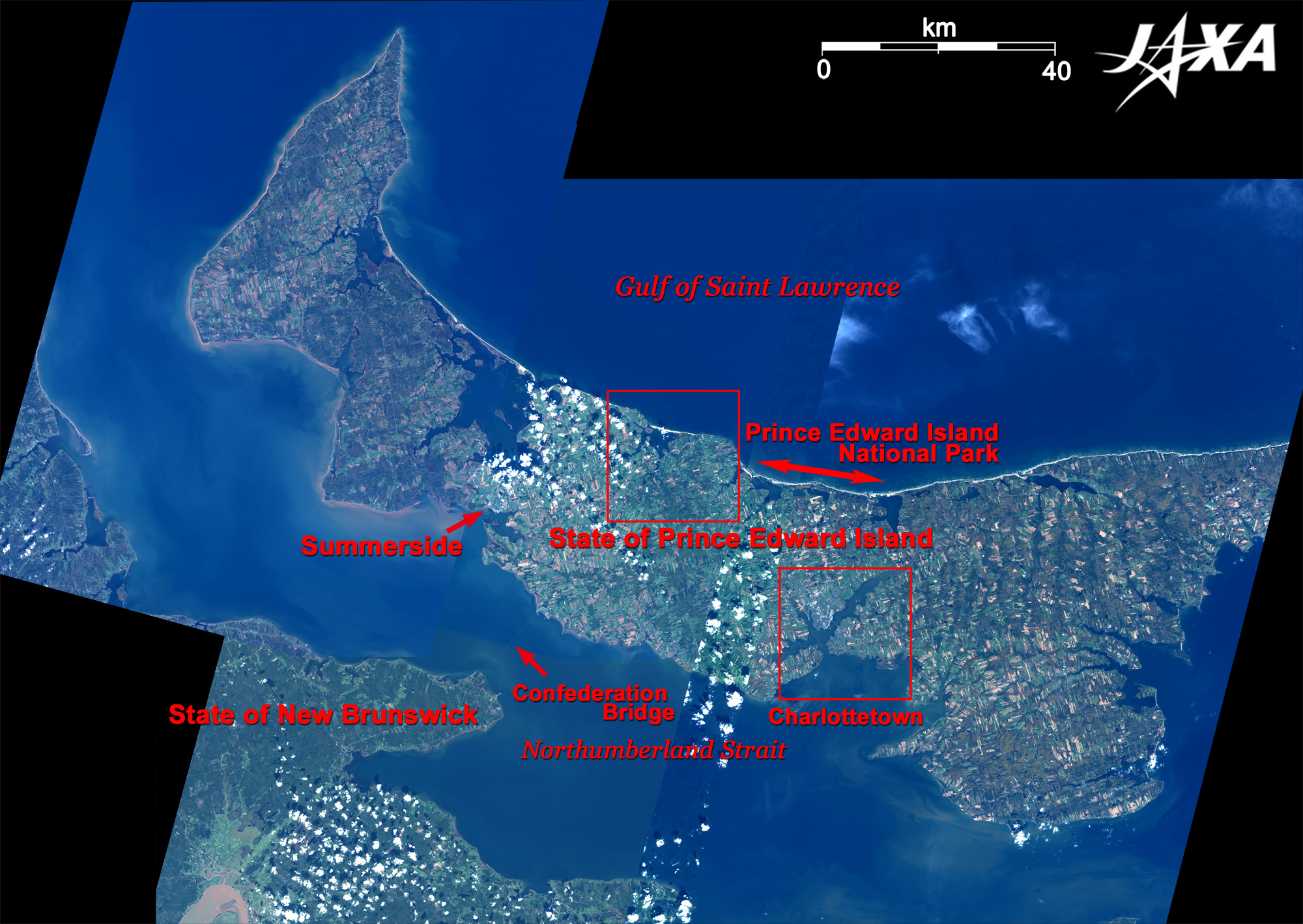
Prince Edward Island is a flat, crescent-shaped, long and thin island, 224km long east to west and 6 to 64km wide north to south, with a highest point of 152m. The northern sea coast of the island extending from Dalvay Beach to Cavendish Beach, facing the Gulf of Saint Lawrence, is a national park and is also the top seashore resort in Canada. With 36 province parks and more than 70 campsites, the whole island is like a park. Summerside on the south coast has long been a popular resort, and many people from the United Provinces stay there in summer. The land is fertile red soil with 80% of the area cultivated, thus it is called "Farm of One Million Acres." As seen from the figure, the island has more farmland than the continent. Barley, rye, potato etc. are grown, and potato is the prime product of Prince Edward Island. However, this island is particularly famous as the home of Lucy Maud Montgomery who lived on this island and wrote the series "Anne of Green Gables." The left red square in the figure is the model area of Avonlea, the home of Anne, and Cavendish where Montgomery was born and raised.
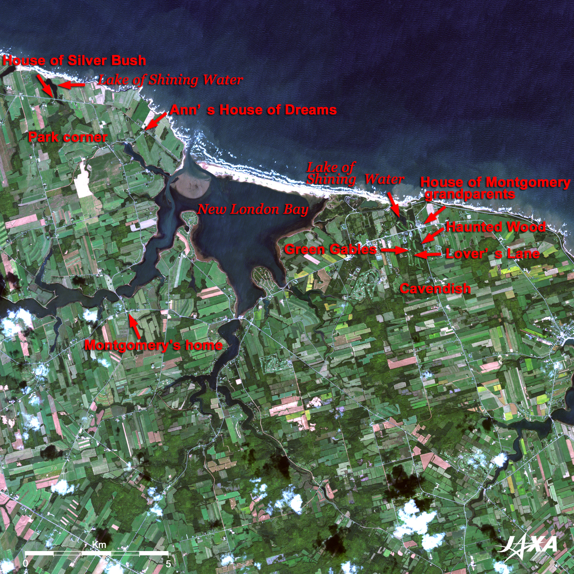
"Anne of Green Gables" was published in 1908 and told the story of Anne from 11 to 16 years old. Montgomery lived in the area of New London Bay in the center of the image. Montgomery was born in 1874 in New London on the south coast of the bay, and the house is now open to the public as L. M. Montgomery's Birthplace. Montgomery's mother wasdied when she was one year and 9 months old, and her grandparents took care of her and raised her in Cavendish on the east coast of the bay. Locales of "Anne of Green Gables" such as "Green Gables," "Lover's Lane," "Haunted Wood," and "Lake of Shining Water" can be seen there today. The farm of the Campbells, which is the second home of Montgomery, is located at Park Corner on the west coast of a bay. This is the house of her maternal aunt and is called "House of Silver Bush." She celebrated a wedding there in 1911, wearing an ivory dress and veil, with a bouquet of white roses and lily bells in her hands. A part of the residence is now open to the public as a museum, and the organs and furniture of those days suggest vestiges of the life of "Anne of Green Gables." The house used as the model of the fifth piece of the series, "Anne's House of Dreams," remains on the west coast of the bay. This is where Anne got married and kept house in a fishing village called "Four Winds Point." In the movie "Anne of Green Gables," Anne arrived at Avonlea by train and rode on a carriage toward Green Gables. The roads in the movie were red-soil, but now they are mostly paved and look white. Detailed examination, however, reveals that red-soil roads remain in some places. Railroad construction on Prince Edward Island started in 1871, and after the completion of the main line continued down through the island, with many branch lines crossing and connecting all villages. However, the construction cost far exceeded the plan, and the railroads were abolished in 1989. The railroads have now become the Confederation Trail for hiking and cycling.
In September 1864, "The Charlottetown Conference" was held at Province House, with talks about the federal system inauguration and the independence of Canada in 1867. Thus, this town is known as the Birthplace of Canada. Adjacent to Province House is Confederation Center, which consists of five buildings (a theater, a gallery, a museum, a library, and commemoration hall). The musical "Anne of Green Gables" is performed here every year. Events to commemorate the centennial of "Anne of Green Gables" publication are to be held through the year of 2008 on Prince Edward Island.
|