| |
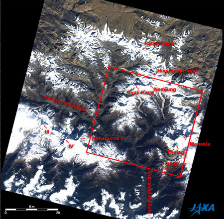 |
Fig. 1 Wide Area Image around Manaslu
Manaslu Himalaya (kmz, 1.89MB, Low Resolution) as seen on Google Earth. |
Figure 1 depicts Manaslu (8,163 m above sea level), one of the eight-thousand-meter peaks in the Himalayas, and surrounding mountains as observed by the Advanced Visible and Near Infrared Radiometer-2 (AVNIR-2) on board the Advanced Land Observing Satellite (ALOS) "Daichi" in November 2006. White indicates clouds or the higher elevations covered with snow and ice. Brown represents arid areas where rocks and soils are exposed. Dark brown indicates lower elevations with dead vegetation. The steep summits and ridges of the mountains cast their own shadows toward the upper left because of the sunlight from the southeast. Most of the figure is the territory of Nepal. The top of the figure is Tibet, China. Ratna Chuli (7,035 m) at the top of the figure is on the border.
Manaslu can be seen on the right edge of the figure. The name comes from Sanskrit words "Manasa" meaning soul or heart, and "lun" meaning country or land. On May 9, 1956, just 50 years ago, a Japanese party led by Yuko Maki, became the first to reach the summit of the world's eighth highest mountain. Thulagi (7,036 m) southwest of Manaslu and the Thulagi Glacier and the glacial lake can be seen south of Thulagi.
In the lower left of the figure, you can see part of the Annapurna mountain group, Annapurna II (7,937 m), Annapurna III (7,555 m), and Annapurna IV (7,525 m). The Marsyangdi Khola (river) flows around the north and east sides of these mountains, joining the Ganges River and emptying into the Bay of Bengal. Another group of mountains, which includes Gyaji Kan (7,038 m), Nemjun (7,139 m), and Himulung Himal (7,126 m), is northwest of Manaslu, and several 10km long glaciers flow from there. Many small glaciers are visible in the cordillera extending to the northwestern side of this mountain group.
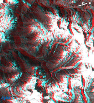 |
Fig. 2 Three-Dimensional View around Manaslu
(Staring at the image for a long time may cause eyestrain. A colored print is available in pdf format. Pdf files for the left and right eyes are also available.) |
Figure 2 depicts a three-dimensional view of the area outlined in red to the right of Fig. 1. It is composed of the nadir- and rear-looking images observed by the Panchromatic Remote-sensing Instrument for Stereo Mapping (PRISM) taken simultaneously with Fig. 1. Note that the right side is north in this figure. If you view Fig. 2 with red and blue glasses, you can distinctly see the steep mountains including Manaslu at the bottom of the figure, as well as deep valleys extending branches, and the glaciers that flow in the upper streams of the valleys.
Explanation of the Images:
(Figs. 1 and 2)
AVNIR-2 has four observation bands. Fig. 1 was composed by assigning red to visible Band 3 (610 to 690nm), green to visible Band 2 (520 to 600nm), and blue to visible Band 1 (420 to 500nm). The resulting image has natural coloring as if seen by the naked eye. In these images, snow and clouds are white, glaciers are white or right brown, exposed rocks, soils and sands are brownish, hay is dark brown.
PRISM is an optical sensor for observing ground surfaces with visible and near-infrared signals in the 520 to 770 nano-meter (one-billionth of a meter) band. The acquired image is monochrome. PRISM has three independent optical systems (telescopes) to acquire images for nadir, forward, and backward views at the same time so that terrain data including altitude data can be obtained.
Fig. 2 was composed using the rear image (red) and the nadir image (green and blue). Parallax, the difference between the sight angle of the image seen with the right and left eyes, is utilized in order to view the three dimensional image. In Fig. 2, the left side is the satellite moving direction because the rear of the satellite is seen with the left eye and the nadir with the right eye. The left side corresponds to the moving direction of "Daichi" and right side to the north. Note that the right side is the north direction in Fig. 2 even though the upper side is north in Fig. 1.
|
 |
|


