Seen from Space 2005
Revolutionizing Bahrain, the first oil-producing country in the Persian Gulf
Figure 1 depicts the island country of Bahrain floating in the Gulf of Bahrain, a part of the Persian Gulf. Bahrain consists of more than 30 islands. Bahrain Island at the center, is adjacent to Muharraq Island, Sitrah Island, Umm Alnasan Island, and Hawar Island that is next to Qatar (outside the figure). The northern part and northwest part of Bahrain Island look green, indicating there is rich vegetation. These areas are mainly farmland. They are irrigated by subsurface water and fresh water produced from seawater by de-salting facilities. Date palms, almonds, pomegranates, figs, citrus fruits, and various kinds of vegetables are cultivated. The northeast area looks grayish purple, indicating the city area, industrial areas and residential areas. The southern part looks whitish indicating a dry zone. Particularly white areas represent exposed limestone. Some areas in the sea around Bahrain appear reddish purple indicating a very shallow sea bottom. A part of Saudi Arabia can be seen at the left edge of Fig. 1. It is connected with Bahrain Island via the desert island Umm Alnasan through the King Fahd Causeway.
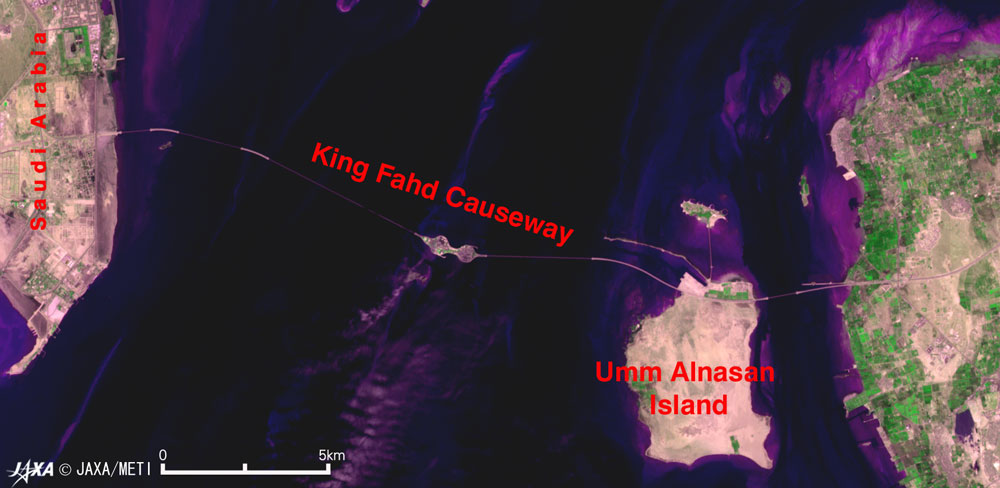
Figure 2 is an enlarged picture of the King Fahd Causeway, commissioned in 1986. It is a full 25-km long. The parts reclaimed from sea look thick, and the bridge parts look thin. A second causeway seems to be under construction in the figure acquired in 1996.
Figure 3 is an enlarged image of Bahrain's major area, including its capital Manama. Muharraq Island in the upper right is densely populated; it has a residential area and a runway of Bahrain International Airport. On the outskirts of Sitrah Island is the industrial area with oil tanks and harbor facilities. In the center of Fig. 3, there are some circular farms that use pivot irrigation and the national stadium where the international football matches are played. There is a green racetrack in the bottom left. You can also see a network of expressways extending in all directions. Bahrain is the first Persian Gulf country in which oil was discovered and mined. The first oil field was discovered in 1931 at Oil Well No. 1 near the hill of Jebel Dukhan, the highest spot on Bahrain Island. The dig was started in 1932. They discovered there were few deposits and compared it with that in Saudi Arabia, the world's largest oil-producing country, and predicted wells would dry up in the near future. In order to switch the economic structure depending only on oil and natural gas, they have been constructing an infrastructure and developing oil and aluminum refining industry, the shipbuilding industry, and finance and trade service for the past 20 to 30 years, and there is now emphasis on development of tourism. According to the homepage of the Economic Development Board in Bahrain, they are implementing many projects such as container bases, harbor facilities, a finance center, a theme park, a causeway between Bahrain and Qatar, a golf club, the international circuit, and a hot springs resort. JAXA will launch the Advanced Land Observing Satellite (ALOS) in the fall of this year carrying the Advanced Visible and Near Infrared Radiometer Type 2 (AVNIR-2) capable of 10 m ground resolution. We are planning to distribute clearer images at that time. Reference Site: Bahrain Government Site
Related Sites: Appendix: Old burial mounds There are many old burial mounds on Bahrain Island and Hawar Island, including A'ali of Fig. 3. The total is estimated to exceed 100,000 and to cover approximately 50 square km. A considerable number of mounds seem to have been destroyed by the recent development of a road network. In each old burial mound there were one or two stone chambers with a corpse lying in state. The mounds became hillocks when covered with soil. There are numerous hillocks in the area of the old burial mounds. The oldest mounds were made 2500 to 2300 BC and are the largest of the prehistoric cemeteries in the world. The shape and size are classified into three or four kinds by determining when the mound was made . The biggest mounds are more than 45 m in diameter and more than 10 m high. As a result of continuous excavation since 1879, the grave contents, such as pottery jars, stone tools, Dilmun seals, lucky charms made of shellfish, tools and weapons of bronze have been recovered and indicate that there was once a well developed society . |
|||||||||||||||||||||||