| |
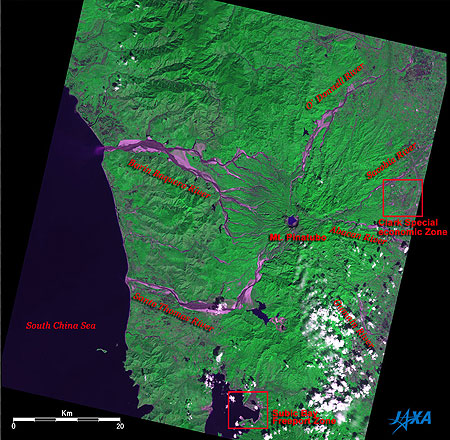 |
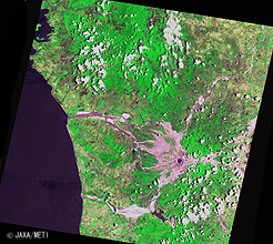
Fig. 1 Mt. Pinatubo 15 years after the eruption
Mt. Pinatubo (kmz,1.07MB,Low Resolution) is seen from Google Earth. |
Figure 1 depicts Mt. Pinatubo, as observed by the Advanced Visible and Near Infrared Radiometer-2 (AVNIR-2) on board the Advanced Land Observing Satellite (ALOS) Daichi in November 2006. The figure looks dark green for the most part, indicating that the area is covered with forest or jungle. There is a large lake 2km in diameter within the crater on Mt. Pinatubo. The east side of the lake is covered with volcanic ash and looks ashy purple. Huge amounts of ashy-purple-looking volcanic ash still remain in the basins of the O'Donnell River on the north side, the Balin Baquero River on the west side, and the Santo Thomas River on the southwest side of Mt. Pinatubo. The Clark Special Economic Zone is on the right of the figure and Subic Bay Freeport Zone is on the bottom.
Mt. Pinatubo, which once rose 1,745m above sea level, is located approximately 90km northwest of Manila, the capital of the Philippines, on central Luzon. A major eruption in June 1991 blew away its crest. The summit fell as much as 260m, the 2.5km diameter crater emerged, and the crater lake was formed. On June 15, during the largest eruption in the 20th century, volcanic fumes reached the stratosphere, and it is estimated that it decreased the air temperature in the Northern hemisphere by 0.5 to 0.6°C.
 |
 |
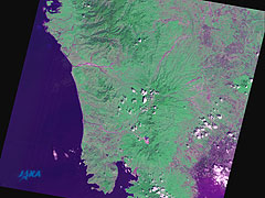
| (a) October 31, 1990 |
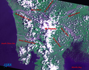
(b) July 5, 1991 |
 |
 |
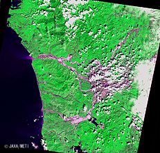
| (c) November 6, 1993 |
(d) April 18, 1995 |
 |
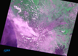
| (e) April 19, 1997 |
| Fig. 2 Changes around Mt. Pinatubo |
Figures 2a to 2e present Mt. Pinatubo and its vicinity, as observed by the optical sensors on board the Marine Observation Satellites Momo-1 (MOS-1) and Momo-1b (MOS-1b), the Japanese Earth Resources Satellite-1 Fuyo-1 (JERS-1), and the Advanced Earth Observing Satellite Midori (ADEOS).
Figure 2a, which was acquired before the eruption, depicts the areas along the O'Donnell River, the Balin Baquero River, and the Santo Thomas River as being ashy purple, indicating that rocks and dirt are exposed.
Figure 2b, which was acquired during the eruption, shows that volcanic ash covered an extensive area of the Earth's surface and that the volcanic fumes rise from the crater of Mt. Pinatubo and flow to the northwest. The mountain spouted the volcanic ash continuously since the major eruption in June 1991 until August of the same year.
Figures 2c and 2d, acquired 1.5 years and 2 years after the eruption, show that the volcanic ash remains around the summit of Mt. Pinatubo and on the basins of the surrounding rivers. You can see that the volcanic ash is pouring from the mouth of the Balin Baquero River into the South China Sea. Figure 2d pictures the crater lake.
Figure 2e, which was acquired 6 years after the eruption, depicts volcanic ash remaining in the basins of the Sacobia River and the Bamban River in the northeast side, and the Abacan River on the east side of Mt. Pinatubo, although the areas around the mountaintop can't be seen because of the cloud cover there.
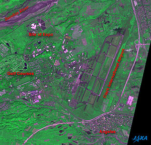 |
| Fig. 3 Clark Special Economic Zone and Angeles |
Figure 3 is an expanded image of Fig. 1. You can see the Clark International Airport, which has the 4,000m-long runways, in the center; the site of Expo is in the upper left; the golf courses on the left; and the city area of Angeles in the lower right.
Clark Air Base, which was the largest in the foreign countries and was used by the U.S. Air Force from 1903 to 1991, was 20 km east of Mt. Pinatubo, but all base personnel took refuge before the eruption of Mt. Pinatubo, and the base was closed down. The base was returned to the Philippines in November 1991 after the Philippine Senate refused to extend the Military Base Agreement between the U.S.A. and the Philippines that September. The removal of the accumulated volcanic ash was started in 1995. Clark Air Base was redeveloped and then reborn as the Clark Special Economic Zone containing the Clark International Airport.
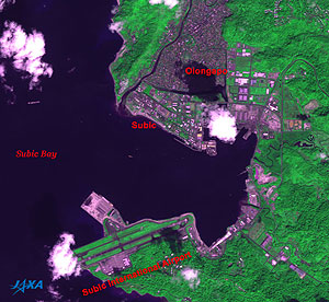 |
| Fig. 4 Subic Bay Freeport Zone |
Figure 4 is another expanded image of Fig. 1. Although dotted clouds cover some areas, you can see Subic Bay on the left, the Subic Bay International Airport at the bottom, and the city areas in Subic and Olongapo at the top.
Subic Bay Naval Base, which Spain began to use in 1884 and U.S. Navy used from 1898 to 1991, was 35km south of Mt. Pinatubo. This base was the second largest overseas base following Clark Air Base. It was heavily damaged by the major eruption of Mt. Pinatubo but had almost recovered in one month. However, when the Philippine Senate refused to extend the Military Base Agreement, the U.S. Navy withdrew by November 1992 and the base was returned to the Philippines. Subic Bay Naval Base was then redeveloped as the Subic Bay Freeport Zone including neighboring Olongapo City.
Explanation of the Images:
(Figs. 1, 3 and 4)
AVNIR-2 has four observation bands. Figs. 1, 3 and 4 were composed by assigning red to visible Band 3 (610 to 690nm), green to near-infrared Band 4 (760 to 890nm), and blue to visible Band 2 (520 to 600nm). As a result, the figures have a nearly natural coloring, with vegetation slightly emphasized. In these images, clouds are white, exposed rocks and volcanic ash, roads, runways and buildings are grey purple, farmland and grassland are light green, and forests are dark green. Water surfaces (seas and lakes) are dark blue or black. Areas with no data are black. North side slopes look blackish.
(Figs. 2a and 2b)
These images were produced by assigning red to the visible channel (610 to 690 nm), green to the near-infrared channel (720 to 800 nm), and blue to the visible channel (510 to 590 nm). You can interpret the resulting images in the almost same way as the above AVNIR-2 images.
(Figs. 2c and 2d)
These images were produced by assigning red to the visible channel (630 to 690 nm), green to the near-infrared channel (760 to 860 nm), and blue to the visible channel (520 to 600 nm). You can interpret the resulting images in the almost same way as the above AVNIR-2 images.
(Fig. 2e)
AVNIR has four observation bands. This images was produced by assigning red to the visible Band 3 (610 to 690 nm), green to the near-infrared Band 4 (760 to 890 nm), and blue to the visible Band2 (520 to 600 nm). You can interpret the resulting images in the almost same way as the above AVNIR-2 images.
|
 |
|


