| |
 |
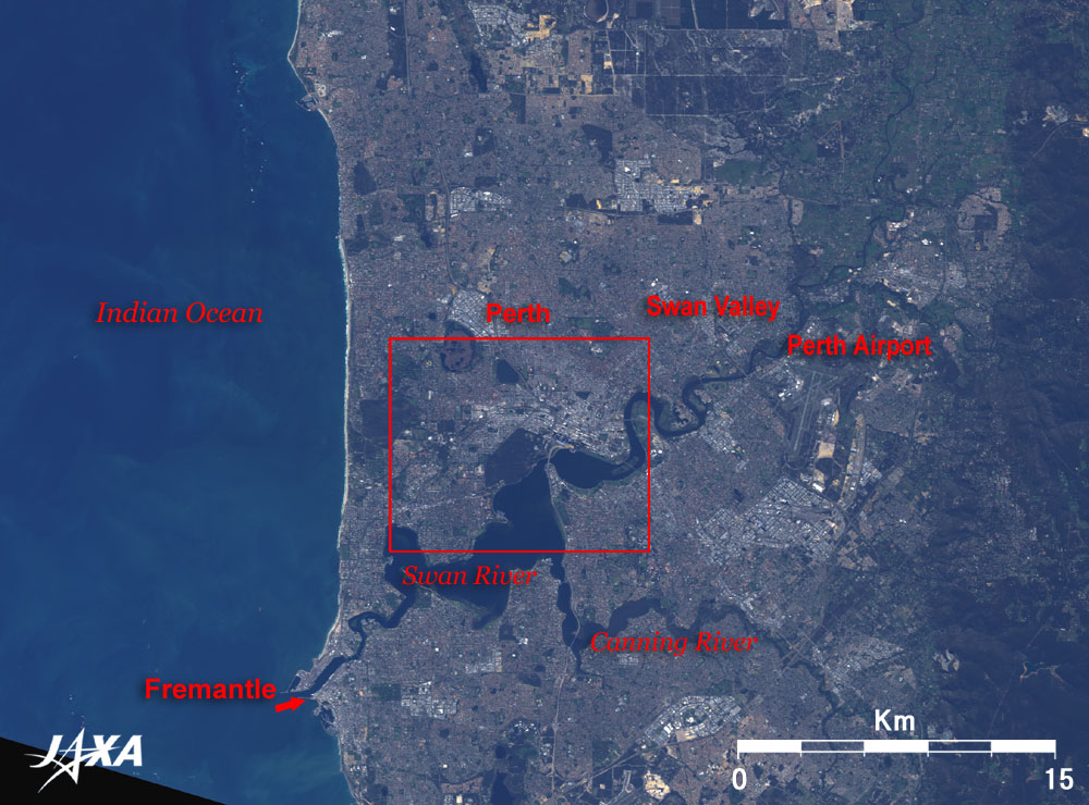
| Fig. 1 Perth and vicinity |
Figure 1 depicts Perth, state capital of Western Australia, Australia, as observed by the Advanced Visible and Near Infrared Radiometer-2 (AVNIR-2) on board the Advanced land Observing Satellite (ALOS) "Daichi" in August 2006. The left side of the figure is the Indian Ocean, and the whole land area appears brownish because the plants are withered in winter. As Australia is located in the southern hemisphere, August is in the winter season. The Swan River flows from the upper right to the lower left. The City of Perth is located north of where the river widens. The Canning River flows from the lower right to the center of the figure and joins the Swan River. The Perth International Airport is in the right of the figure, and some city areas are visible in the suburbs of Perth. The upper part of the figure contains some space communication stations of the Japan Aerospace Exploration Agency (JAXA) and the European Space Agency (ESA).
Perth is the fourth largest metropolitan area in Australia with a population exceeding 1.5 million, consisting of the City of Perth with a population of 80,000, and over 30 cities and towns including Fremantle and Canning. The state of Western Australia occupies one third of the area of Australia and has a population of 1.8 million. You can thus say that most people in the state live in Perth.
Fremantle, the port city in the mouth of the Swan River, was established in 1829 and faces the Indian Ocean. It has provided many tourist attractions since the first immigration. For example, it is the home of the Australian National Maritime Museum, which houses the 12-meter class yacht, Australia II, that carried the Australian team to victory in the America's Cup for the first time in September 1983. It also has wrecks of ships several hundred years old and various other attractions. The city also hosts the Japanese Antarctic research ships, Soya (1956-1962), Fuji (1965-1983) and Shirase (1983-2008) when they stop over. From Fremantle to the north and bordering in the Indian Ocean is a 30km long beautiful white sandy beach well known for its beautiful scenic views at sunset.
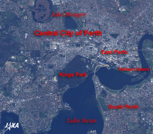 |
Fig. 2 Close-up of Perth
Perth (kmz, 1.37MB, Low Resolution) as seen on Google Earth. |
Figure 2 presents a close-up image of Perth. The central city area of Perth is located on the north shore of Swan Lake, a part of the Swan River. The Swan Lake is named after the black swans that inhabit the area. The dark green area in the center of the figure is Kings Park where you can overlook the downtown with a lot of the skyscrapers along the Swan River. This four square kilometer large, hilly city park is bigger than Central Park (3.2 square kilometers) in Manhattan, New York. There are many other parks and avenues in addition to this one. The skyscrapers that shade themselves are headquarters buildings of the mining companies and the petroleum companies, constructed from the 1960s to the 1980s to replace the Victorian age buildings.
Perth enjoys a calm Mediterranean climate throughout the year and is called the most beautiful city in the world. Recently, the number of retired Japanese immigrating to Perth has increased. In Japan, the baby boom generation will retire after 2007. Will Perth be one of their candidates for retirement living? On the negative side, Perth is close to the South Pole and the ultraviolet radiation is several times stronger than in Japan. In particular, the Ozone Hole in the South Pole approaches nearest in November, and sunburn protection is necessary.
Explanation of the Images:
(Fig. 1 and 2)
| Satellite: |
Advanced Land-Observing Satellite (ALOS) (Daichi) |
| Sensor: |
Advanced Visible Near-Infrared Radiometer type-2 (AVNIR-2) |
| Date: |
0156 (UTC) on August 17, 2006 |
| Ground resolution |
10 m |
| Map Projection: |
Universal Transversal Mercator (UTM) |
AVNIR-2 is equipped with a pointing function by which it can shift its observation area perpendicular to the ALOS's moving direction, and it can observe ground surfaces with four spectral bands.
AVNIR-2 has four observation bands. The composite image is usually produced by assigning red to Band 3 (610 to 690nm), green to Band 2 (520 to 600nm), and blue to Band 1 (420 to 500nm). The resulting image has natural coloring as if seen by the naked eye. Thus the ground objects are distinguished by the following colors. |
| Deep green, brown: |
Forests |
| Green or khaki: |
Grass fields, farms |
| Bluish grey: |
City area or roads |
| Red, blue, White: |
Roofs |
| Blue, dark greenish blue: |
Water surfaces (sea, lakes, rivers) |
| Black: |
The area with no data |
|
 |
|