| |
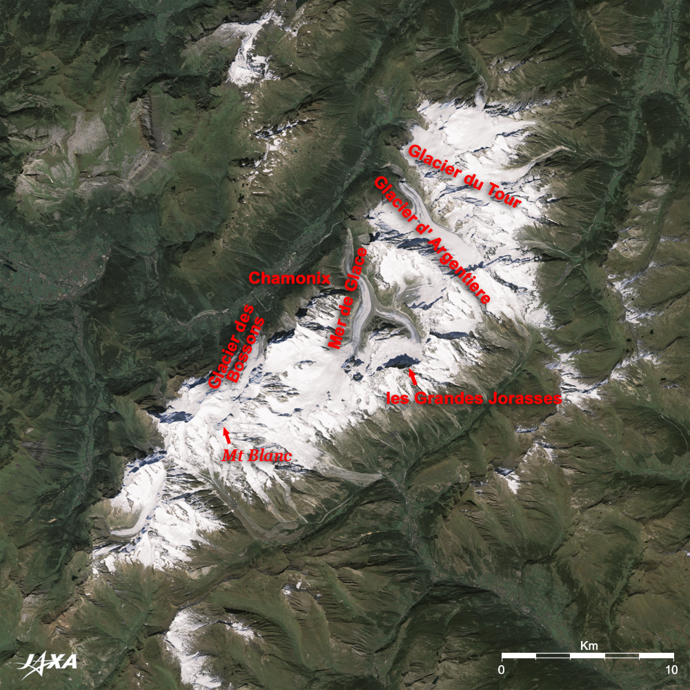
Figure 1 depicts Mont Blanc and its vicinity as observed by the Advanced Visible and Near Infrared Radiometer-2 (AVNIR-2) on board the Advanced Land Observing Satellite (ALOS) "Daichi" in September 2006. The white part in the center of the figure is the Mont Blanc massif covered by snow and ice. It includes Mont Blanc (4,827m), the highest peak in the European Alps; Grandes Jorasses (4,208m), one of the three major north walls in Europe; numerous Aiguilles Rouges (red needles); and glaciers. Many summits cast their shadows toward the north, but there is hardly any shade on the gently sloping Mont Blanc. Grandes Jorasses is not well known like the three major north walls (Grandes Jorasses, Eiger, and Matterhorn), but its big shadow reveals that climbing its north wall is the most difficult. A stair-like striped pattern, which is clearly visible on the surface of Mer de Glace glacier in the center of the figure, indicates a grand glacial flow.
Chamonix, considered a skier's mecca, is located in the center of the valley along the northwest Mont Blanc group. It is a resort town famous for mountain climbing and vacationing in summer, and skiing in winter. You can easily reach places 4,000m above sea level by aerial cableway. An aerial cableway and gondola connecting Aiguille du Midi observation platform (3,842m) in France and Helbronner observation platform (3,462m) in Italy is blessed with a fine view of the great Alpine landscape and glaciers. The first Winter Olympics were held in Chamonix in 1924.
Although it is not visible in the figure, Mont Blanc Tunnel runs below the northeast side of Mont Blanc from northwest to southeast. This 11.6km tunnel connecting Chamonix, France, and Courmayeur, Italy, was opened for traffic in 1965 and has become a main artery between North Europe and Italy. However, a tragic accident in March 1999 caused it to be taken out of service for three years. Major improvements for enhancing safety were made during those years, and it was re-opened for traffic in March 2002.
 |
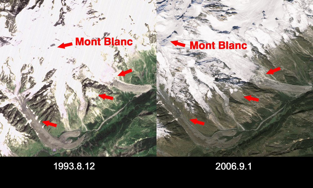
| Fig. 2 Glacial Changes |
Glaciers, which create the geographical features of the Alps, flow dozens of centimeters per year, but the leading edges have recently been retreating at a rate of 20cm per year due to global warming. The changes of glaciers around Mont Blanc can be understood by comparison with an image acquired by the Visible and Near Infrared Radiometer (VNIR) on board the Japanese Earth Resources Satellite-1 (JERS-1) "Fuyo-1" in August 1993. Arrows in Fig. 2 indicate areas where frozen snow has disappeared. The influence of global warming is more evident on the south slope of Mont Blanc. It must be noted that the glaciers look somewhat different since the left figure is a nadir image but the right one is a 34.3° oblique-looking image toward west-northwest.
Explanation of the Images:
(Fig.1, Fig. 2 right, and the full image)
| Satellite: |
Advanced Land-Observing Satellite (ALOS) (Daichi) |
| Sensor: |
Advanced Visible Near-Infrared Radiometer type-2 (AVNIR-2) |
| Date: |
1417 (UTC) on May 28, 2006 |
| Ground resolution |
10 m |
| Pointing Angle: |
-34.30° |
| Map Projection: |
Universal Transversal Mercator (UTM) |
AVNIR-2 has four observation bands. The composite images are usually produced by assigning red to Band 3 (610 to 690nm), green to Band 2 (520 to 600nm), and blue to Band 1 (420 to 500nm). The resulting image has natural coloring as if seen by the naked eye. In these images, snow and ice are white or light grey, urban area are light grey, forests are dark green, grasslands are green-yellow, and glacier lakes are light blue. Areas with no data are black.
In the above figures, red is assigned to the sum of 75% of Band 3 and 25% of Band 4, green is assigned to the sum of 70% of Band 2 and 30% of Band 4, and blue is assigned to the sum of 75% of Band 2 and 25% of Band 4, resulting the visibilities of the shades around summits are improved.
|
(Fig.2 left)
| Satellite: |
Japanese Earth Resources Satellite-1 (JERS-1) (Fuyo-1) |
| Sensor: |
Visible and Near Infrared Radiometer (VNIR) |
| Date: |
1038(UTC) on August 11, 1993 |
| Ground resolution |
18.3 m x 24.2 m |
| Map Projection: |
Universal Transversal Mercator (UTM) |
| The composite images are usually produced by assigning red to the Band 2 (630 to 690 nm), green to the near-infrared Band 3 (760 to 860 nm), and blue to the visible Band 1 (520 to 600 nm). In the above figure, green is assigned to the sum of 80% of Band 2 and 20% of Band 3. The resulting figure has natural coloring as if seen by the naked eye. In this image, snow and ice are white or light purple, urban area are light grey, forests are dark green, and grasslands are green-yellow. |
|
 |
|