Seen from Space 2006
Eiger and Jungfrau: The Renowned Peaks of the Alps
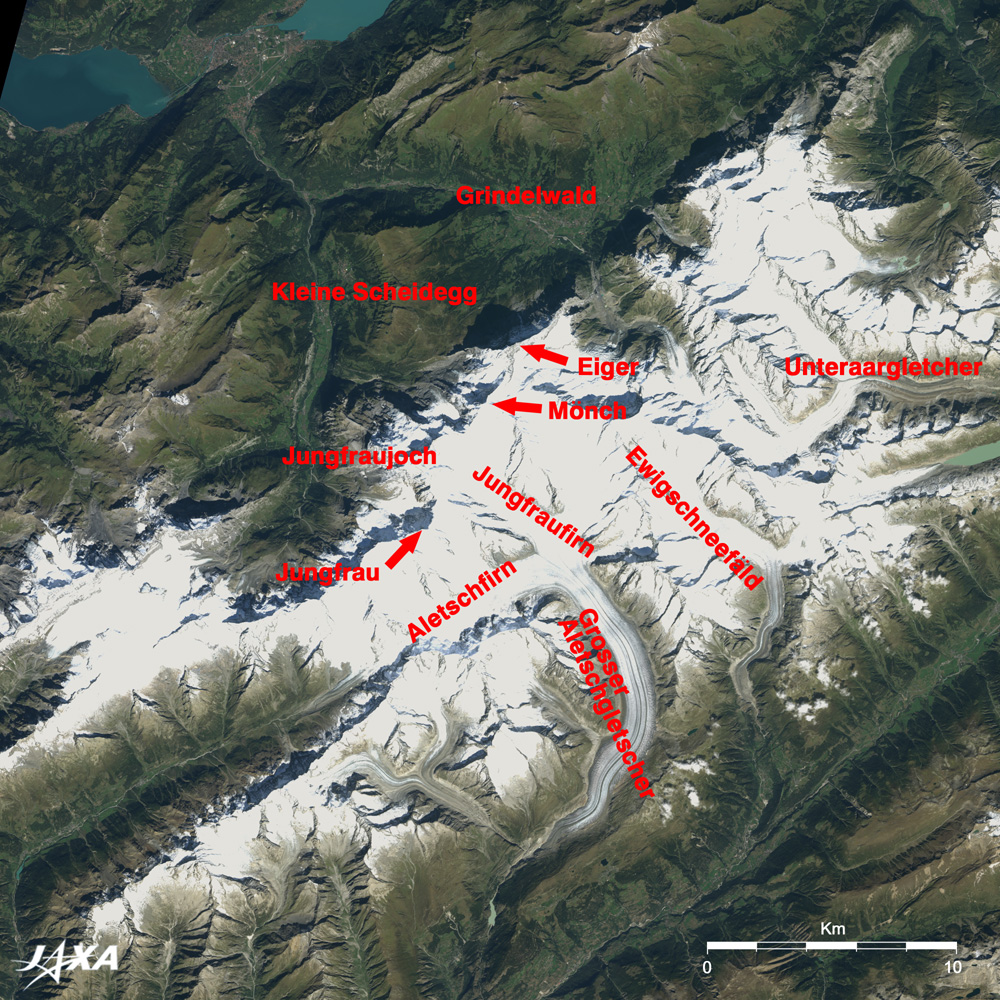
Eiger (3,970m), Mönch (4,099m), and Jungfrau (4,158m), towering pinnacles of the Alps, stand in line in the white mountains at the center of the figure. Illumination from the southeast causes some mountains to cast their own dark blue shadows over the white background. The snow and ice-covered summits are difficult to see, but Eiger is easily identified. The Eiger Nordwand (North Wall), one of the three Great North Walls in the Alps, is a sheer cliff with a vertical drop of 1,800m. Its silhouette, cast toward Grindelwald at the foot, reveals the shape of the mountain. Aletsch Glacier (Grosser Aletschgletscher) is a 24km long massive formation and is the largest and longest glacier in Europe. Some black streaks are visible over the white canvas. This glacier moves an average of several centimeters per day. It curves down the rocky mountain taking countless rocks along in its flow, forming the black streaks. Two of these streaks, looking like wheel ruts, tell that three upstream glaciers, Aletschfirn (Aletsch snowy field), Jungfraufirn (the Jungfrau snowy field), and Ewigschneefäld (Ewig ice field)) join to form the larger glacier. Aletsch Glacier was added to the World Natural Heritage list of UNESCO in 2001 as "Jungfrau-Aletsch-Bietschhorn," together with the 4,000m-class mountains including Eiger, Mönch, and Jungfrau. Since the glacier records the history of the Earth and is closely connected with climate changes such as global warming, the glacier and surrounding forests were recognized as an inheritance that should be protected. Berner Oberland is the most popular tourist district in Switzerland. A mountain railway network has been developed to protect the natural site. Jungfrau railway starts from Kleine Scheidegg, runs mostly in tunnels, and reaches the underground terminal Jungfraujoch (3,454 m), the highest railway terminal in Europe. Joch means col in German. The Sphinx Observation Deck immediately above the terminal extends to the col between Mönch and Jungfrau. With Jungfrau close at hand, and the great Aletsch Glacier in front, this observation deck is a perfect sightseeing spot. It is said that the philosopher Jean-Jacques Rousseau, having discovered the beauty of the Alps and having introduced its breathtaking landscape to Europeans in the 18th century, promoted this area by saying, "Return to nature." The name of the mountain range, the Alps, came from the high pasture (alp). The Alps became the mountaineer's mecca in the 19th century, and the term "alpinist" now refers simply to a mountaineer. It has become a common part of the name of many high mountain ranges that stand in a row, such as the Japan Alps and the Southern Alps on the South Island of New Zealand.
|
||||||||||||||||||