| |
 |
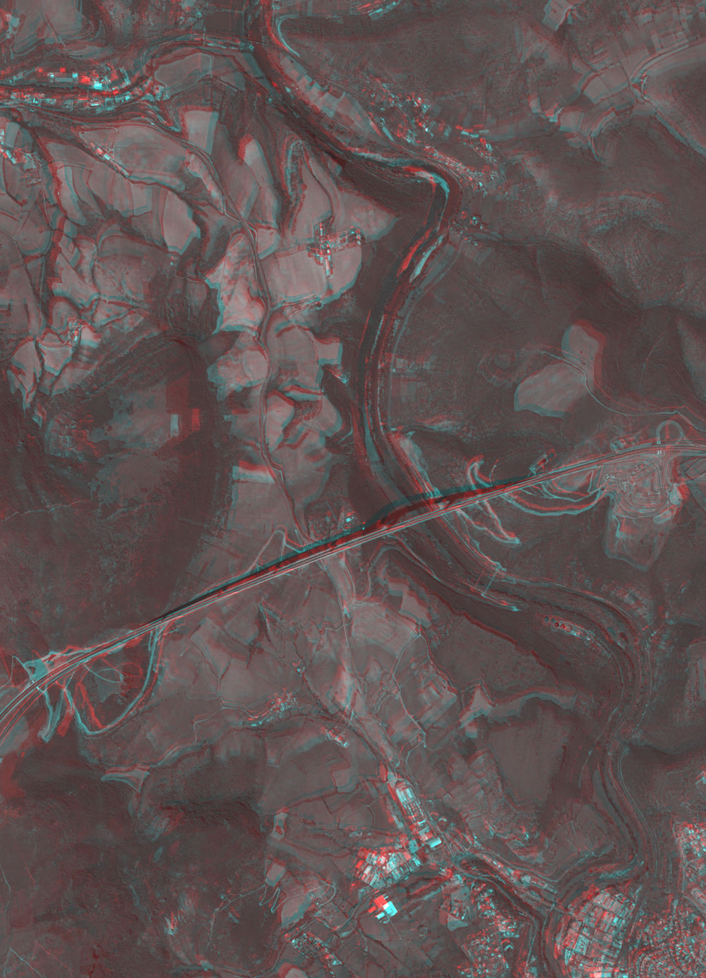
Fig. 1. Three-dimensional view of Millau Viaduct
(Caution should be exercised when viewing this image, as prolonged exposure could result in eye fatigue. After printing with a color printer, use this pdf file. We prepared separate pdf files for the left and right eyes.) |
Figure 1 depicts Millau Viaduct in Southern France as observed by the Panchromatic Remote-sensing Instrument for Stereo Mapping (PRISM) on board the Advanced Land Observing Satellite (ALOS) Daichi in July 2006. The viaduct extends to the right and left in the center of the figure, and the Tarn River meanders from near the city of Millau in the lower right to the top of the figure. You can see that the river makes a deep valley and that Millau Viaduct joins the highlands on either side beyond the valley when you view Fig. 1 with red and blue glasses. When viewed from just the left side, the seven piers of the viaduct look natural. The second pier from the right (the north side) is 343 m high, higher than Tokyo Tower (333 m) or the Eiffel Tower (324 m). Local residents are proud of having the world's tallest structure.
The 2,460 m long Millau Viaduct is a cable-stayed road bridge, and the road runs 270 m above the Tarn River at its highest.
 |
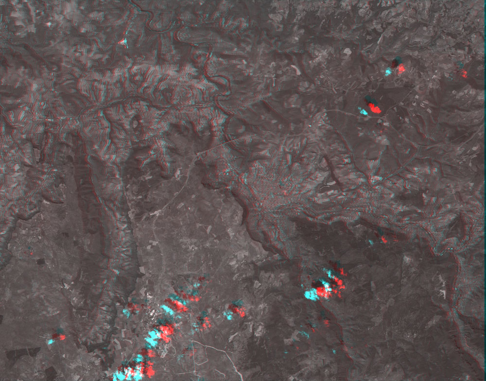
| Fig. 2. Three-dimensional view of the area around Millau Viaduct
(Caution should be exercised when viewing this image, as prolonged exposure could result in eye fatigue. After printing with a color printer, use this pdf file. We prepared separate pdf files for the left and right eyes.)
|
If you view Fig. 2 with red and blue glasses, you can see Causse du Larzac that spreads across the surface at the bottom (east side) of the figure, large valleys that meander across the surface and extend branches, the Causse Rouge in the upper right (northwestern side) that has many undulating hills, the Millau Viaduct that was built across the narrowest section between the Causse du Larzac and the Causse Rouge, the city area of Millau that extends to the valley created by the Tarn River, and some clouds with their shadows.
This area is a part of the Massif Central, which extends from southern to central France. The area includes dry highlands with limestone deposits called "causse" in French. Deep gorges were formed, and there are some features peculiar to limestone deposits, such as limestone caves and potholes.* The A75, a 340 km long expressway linking Clermontferrand about 350 km south of Paris and Beziers near the Mediterranean Sea, runs primarily through the highlands in this area and crosses the Tarn Gorge. Since Millau Viaduct opened in December 2004, the A75 has been an important bypass linking Paris and the Mediterranean Sea.
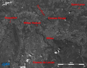 |
Fig. 3. Map of Millau Viaduct and its vicinity
Millau Viaduct(kmz, 1.24MB, Low Resolution) as seen on Google Earth. |
Roquefort, the production center of blue cheese, can be seen in the upper left of Fig. 3, and Saint-Le'on, where Jean Henri Fabre (author of Entomological Souvenirs) was born, can be seen in the upper right.
Explanation of the images:
Figs. 1 to 3
| Satellite: |
Advanced Land-Observing Satellite (ALOS) (Daichi) |
| Sensor: |
Panchromatic Remote-Sensing Instrument for Stereo Mapping (PRISM) |
| Date: |
1048 (UTC) on July 18, 2006 |
| Ground resolution: |
2.5 m |
| Map Projection: |
Universal Transversal Mercator (UTM) |
| Figures 1 and 2 were composed by using the back-looking image (red) and the nadir image (green and blue); Fig. 3 was produced by using the nadir image. In Figs. 1 and 2, the left side is the satellite flight direction because the back-looking image of the satellite is seen with the left eye and the nadir image with the right eye. The left side nearly corresponds to the south. Note that the right side is the north direction in Figs. 1 to 3 even though the upper side is usually north in most satellite images. |
|
 |
|