| |
 |
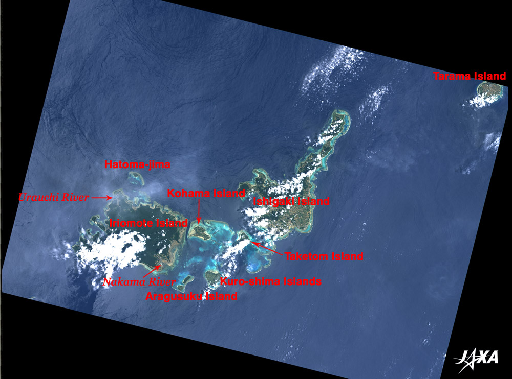
Fig. 1 Central Area of Yaeyama Islands
Yaeyama Islands(kmz, 2.16MB, Low Resolution) as seen on Google Earth. |
Figure 1 depicts Yaeyama Islands, Okinawa Prefecture, (except for Yonaguni Island and Hateruma Island) as observed by the Advanced Visible and Near Infrared Radiometer-2 (AVNIR-2) on board the Advanced Land Observing Satellite (ALOS) "Daichi" in July 2006.
Two big islands in the center of the image are Ishigaki Island in the east and Iriomote Island in the west. Tarama Island is in the upper right of the image. Taketomi Island, Kohama Island, Kuro-shima Islands, and Aragusuku Island (composed of Kamichi Island and Shimochi Island) are visible between Ishigaki Island and Iriomote Island, but the southern half of Taketomi Island and part of Ishigaki Island and Iriomote Island are covered with white clouds. The hazy white area on the sea north of Ishigaki Island is a thin cloud.
The northern area of Ishigaki Island is covered with dark green forests, and the southern area is light brown, indicating farmland. Most of Iriomote Island, except for coastal areas, is covered with dark green forest.
Yellow-green or light-blue coral reefs surround each island. The sea between Ishigaki Island and Iriomote Island is called Sekisei Lagoon, which is the largest coral reef in Japan. These coral reefs together with islands in the lagoon and the mountainous area in Iriomote Island were designated as Iriomote National Park in 1972.
When the image was obtained, there was a 3m/sec wind blowing north by northeast. The dark-blue sea southwest of Iriomote Island was on the leeward side of the island where the wind was weak. On the northwest offshore area of Iriomote Island, something like black "wrinkles" are visible on the sea surface. Light and wind create this feature. If ripples form uniformly over the whole sea surface, the sea surface shines bright with reflection of the sun light. However, where there is a lull in the wind and the sea is calm or if there are large waves or swells, the sea surface looks dark as it does not reflect much sunlight to the satellite.
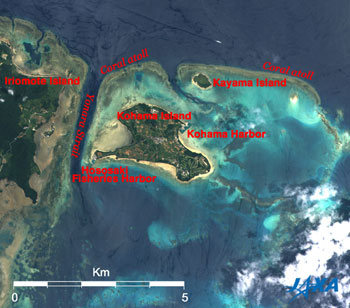 |
| Fig. 2 Enlarged Image of Kohama Island and Vicinity |
Figure 2 depits Iriomote Island on the left and Kohama Island in the center. The sea around Yonara Strait between Iriomote Island and Kohama Island is a hot diving spot where schools of mantas migrate. Yonara Strait is 9 to 30m deep; deeper sea looks darker. This area is called Manta's Way, and mantas are often seen by "waiting" style diving from April through June.
A coral atoll surrounding Kohama Island and Kayama Island is visible on the east of Manta's Way. The light-blue or blue-green area inside the atoll indicates shallow coral reefs. Light-brown seashores of Kohama Island are shoaling beaches. Kohama Harbor in the northeast of Kohama Island is connected with Ishigaki Island by ferry and high-speed craft. Hososaki Fisheries Harbor is at the cape southwest of Kohama Island. Since the water is deep in the dike, both harbors look dark blue. Agriculture is practiced on Kohama Island, and sugar cane fields can be seen in a grid pattern. Golf courses are also visible on the southeast of the island. NHK's (Nippon Hoso Kyokai's) morning drama series "Chura-san" that was aired on TV from April to September in 2001 was shot on this Island. "Chura-san" means pretty girl in Okinawa dialect.
Explanation of the Image:
Figs. 1 and 2
| Satellite: |
Advanced Land-Observing Satellite (ALOS) (Daichi) |
| Sensor: |
Advanced Visible Near-Infrared Radiometer type-2 (AVNIR-2) |
| Date: |
1146 (JST) on July 23, 2006 |
| Ground resolution |
10 m |
| Map Projection: |
Universal Transversal Mercator (UTM) |
|
AVNIR-2 has four observation bands. Figures 1 and 2 were produced by assigning red to Band 3 (610 to 690nm), green to Band 2 (520 to 600nm), and blue to Band 1 (420 to 500nm). The resulting image has natural coloring as if seen by the naked eye. Thus, the ground objects are represented by the following colors.
|
| Dark green: |
Forests |
| Green or khaki: |
Grass fields or farms |
| Light brown: |
Sand beaches |
| Bluish grey: |
Urban area or streets |
| Dark blue: |
Deep sea |
| Light blue or light blue green: |
Shallow sea |
| White: |
Clouds or roofs |
|
 |
Related Sites:
 ALOS Research and Application Project ALOS Research and Application Project
Mangrove forest in Iriomote Island observed by synthetic aperture radar
Special Feature on Coral Reef -Part 1- What is Going on with the Coral Reef?
Seen from Space, Land
Appendix:
In Okinawa Prefecture, Iriomote Island is the second and Ishigaki Island is the third largest island following the main island.
Ishigaki Island is located 411km southwest from the main Okinawa Island and 260km east from Taiwan. The central area of the island is mountainous with the highest peaks in the prefecture, and a plain extends over the southern area. It has various and rich natural features, such as gulf coasts, peninsulas, capes, and beaches, and economic activities focus on agriculture, fisheries, and tourism, taking advantage of the subtropical climate and the archipelago formation.
Iriomote Island is mostly mountainous and many large and small rivers. The largest mangrove forests in Japan grow there at the river mouth basins of the Nakama River in the eastern district and the Urauchi River in the western district. Animals and plants of the untouched subtropical zone inhabit Iriomote Island, which is famous for the "Iriomote wild cat" that has been called the greatest biological discovery in the 20th century.
|
|