| |
|
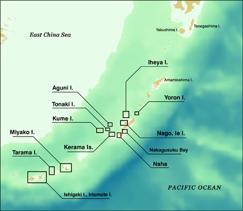
Fig. 1. Map of Main Island of Okinawa and Surrounding Islands
(*Click location name to see satellite images.) |
Satellite images of Figure 1 depict the main island of Okinawa and surrounding islands acquired by the Earth observation satellite LANDSAT-5, 7 of United States. The shining green color near the coast of the islands indicates white sand under the coral reef in the shallow sea reflecting the sunlight. What is going on with this beautiful coral reef in Okinawa ?
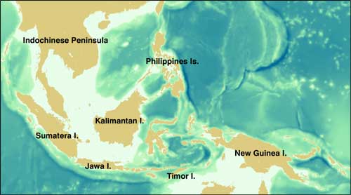 |
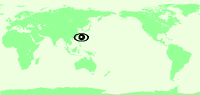
| Fig. 2. Sea Area where Coral is Mostly Found |
Reef-building coral live in shallow seas making corallum, and creating extensive terrain features called coral reefs. This coral is distributed along the seashore in tropical and subtropical areas with water temperatures of 18 to 30°C, found mostly in the sea area surrounding Indonesia, the Philippines, and New Guinea (Fig. 2). In Japan, it is distributed mainly in the sea area south of Tanegashima. Recently, various factors are degrading the environment around coral reefs. The Earth Observation Research Center (EORC) of the Japan Aerospace Exploration Agency (JAXA) collaborated with the Research Institute for Subtropics (RIS) to examine the feasibility of using satellite imagery for an actual survey of coral reef around Okinawa.
 |
 |
| |
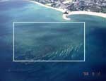
Fig. 3. Coral Reef Bleaching Photographed by Airplane (Nago-city) |
In the summer of 1998, the worldwide seawater temperature rose and coral reef suffered from bleaching on a grand scale. The Coral reef of Okinawa was damaged by that increase in temperature. Coral bleaching occurs when reef-building coral loses zooxanthella living inside them and turn white when its corallum is seen through its body (Fig. 3). Reef-building coral gets most of its energy by photosynthesis of the zooxanthella. Coral bleaching may be caused by losing zooxanthella as the result of extreme high or low seawater temperatures, strong light, ultraviolet rays, and low salt content. If bleaching lasts for long periods of time the coral cannot photosynthesize products from the zooxanthella, resulting in death.
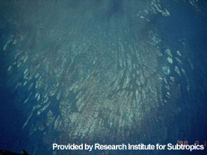
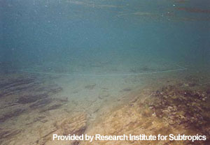
Red-soil runoff from the land in Okinawa is another of the major factors damaging the coral reef's ecosystem. Hard rain causes red-soil runoff to flow from development areas, farmland, and the U.S. Military Base (Fig. 4). We could say that red-soil runoff is caused by stripping forests for development as well as natural factors. The soil of Okinawa contains little humic soil, which serves as an adhesive to hold the soil in place, and allows the soil to flow easily.
 |
|
Fig. 4. Red-Soil Sediment on the Sea Bottom |
As described previously, the coral reef of Okinawa is suffering from bleaching by elevated seawater temperature, red-soil runoff, etc. In an effort to see coral reef distribution, EORC examined the feasibility of using images from the satellite that can continuously observe extensive areas under the same conditions . In the next special feature on coral reef -part 2- "Can a Satellite Detect Coral Reef Distribution?", we will report the process, achievements and problems of our examination to determine coral reef distribution by satellite.
"10 th International Coral Reef Symposium (ICRS 2004 OKINAWA )"
Date: June 28 to July 2, 2004
Venue: Okinawa Convention Center Okinawa , JAPAN
We will present achievements of this collaborative research at the above symposium. For more information, please visit the official website.
|
Acquired image:
<Fig. 1>
|
 |
This is a composite image generated from TM(ETM+)'s three visible spectral channels, channel 3 in red, channel 2 in green, and channel 1 in blue. The image renders colors similar to those seen by the human eye. The original resolution is 30 m.
Landsat is world first Earth observing satellite launched in 1972 by United States , and at present, LANDSAT-5 and 7 are operated. |
Related sites:
 "Coral Reef and Mysterious Sea - Great Barrier Reef" "Coral Reef and Mysterious Sea - Great Barrier Reef"
"Jewel-like colored sea surrounding Cuba and the Bahamas"
"Island floating in the Indian Ocean: Madagascar"
|


