Seen from Space 2005
The Japanese Islands showing fresh greenery, 2005
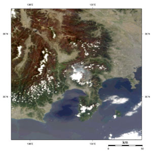
On April 24 (Sunday), Japan was surrounded by a wide migratory high pressure, and a blue sky spread nationwide over the Japanese Islands. In Fig. 1, snow, ice or ice-made clouds appear light blue. Some sea ice remains in the Sea of Okhotsk, and snow remains in the northern, eastern and mountainous parts of Hokkaido. There is also snow in the mountainous parts of Tohoku to Hokuriku on the Sea of Japan side of Honshu. When compared with MODIS images (*1) from the same period last year, Fig. 1 indicates that there was considerably more snow last winter in the area, including the Chuetsu area where the earthquake occurred in the autumn of 2004. The area from Kyushu to Shikoku and Chugoku looks bright yellowish green, which is plant activity. The mountainous area to the east of the Kinki region looks dark brownish green, with plant activity not yet developed. In addition, the flowering of cherry trees was delayed nationwide for ten days or so as compared to 2004, according to "The flowering situation of cherry trees in 2005" as announced by the Japan Meteorological Agency. As of April 26, a cherry tree front appears to be progressing northward in Akita and Iwate Prefectures.
The summit of Mt. Fuji and the western flank of the mountain in the center of Fig. 2 are covered with clouds. Greyish-blue smoke is seen on the northern flank of the mountain. This is the smoke from the burning-off of fields called "Hi-Ire", and 1,900 ha of dry grass was burned. (*1) For example, refer to the images on April 21, 2004 and on May 2, 2004. Please proceed to 2004 -> Apr -> 1km -> 040421 0154 Terra, RcRefl in the page of MODIS near real time data. In addition, please proceed to 2004 -> May -> 1km -> 040502 0312 Aqua, RcRefl.
|
||||||||||||||||||||||||||||||||||