Seen from Space 2004
A Radar View of Southeast Asia - Indochina Peninsula
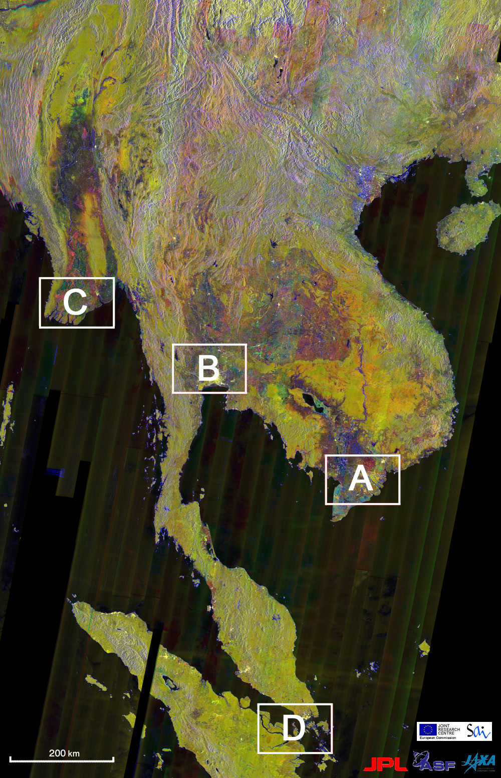
Figure 1 presents a mosaic image covering Southeast Asia and Sumatra. This image was acquired by Synthetic Aperture Radar (SAR) on Japanese Earth Resources Satellite -1 (JERS-1) (*1). SAR is capable of observing land features and land conditions such as forest distribution and soil moisture, and building structures. SAR has the advantage of being able to observe the land surface in detail in spite of cloud cover and darkness. Point the cursor to boxed areas to see larger pictures of (A) the Mekong River Delta, (B) Bangkok City, (C) the Irrawaddy River Delta, and (D) Singapore City. Figure 1 was obtained by overlaying the January and February 1997 dry season image and the August 1998 wet season image (*2). The tropical rainforest with plants growing year round is represented in yellow or olive as shown in C, D. Farming areas where vegetative conditions differ by season, mainly irrigated rice , as shown in A, C are represented in red or green. Urban areas and man-made structures along the streets, shown in B and D are white, while water areas, such as sea, rivers, and lakes, and no-data areas, are black. The mosaics in Fig. 1 were processed within the framework of the Global Forest Mapping Program (GFMP) - a joint international research effort that was established to investigate the spatial distribution of the global forest cover and its variation with fine spatial resolution. GFMP consists of the Global Rain Forest Mapping Program (GRFM) for South-East Asia, Central America, the Amazon Basin and Central, West and East Africa; and the Global Boreal Forest Mapping Program (GBFM) for North America and Eurasia Continent (*3). The Advanced Land Observing Satellite (ALOS) is Japan's next Earth Observation satellite, scheduled for launch in 2005. ALOS is equipped with an improved L-band SAR instrument, called PALSAR as well as two optical sensors. As a continuation of JAXA's on-going JERS-1 SAR GFMP into the era of ALOS, JAXA EORC has initiated the "Kyoto & Carbon Initiative." In an effort to support international environmental conventions and climate change science this international collaborative project uses ALOS to map and monitor the status and changes in forest, wetlands, and land cover over the entire Earth. (*1) SAR is capable of high-resolution, high-contrast observations regardless of weather conditions and lighting. Figure 1 was formed by arranging about 40 days of strip images over a 75 km observational width acquired from a polar orbit of 568 km altitude. (*2) It is a multi-temporal color composite obtained by displaying the 1997 dry season (January and February, 1997) in red, the 1998 wet season (August 1998) in green, and the dry season radar texture (coefficient of variation) in blue. Each mosaic image is created from about 1,800 SAR scenes with 1 km resolution. We should be careful in studying this image because this method of color composite is much different from that of GLI images. (*3) All mosaics processed in GFMP are available free of charge for research and educational purposes, via Internet (500m and 2km spatial resolution) and on CD-ROM/DVD-ROM (including 100m resolution). Related sites: - What We Can Learn from Optical Sensor and Synthetic Aperture Radar Images -
|