Seen from Space 2010
Significant retreats of huge glaciers in Patagonia, South America (Part 3)
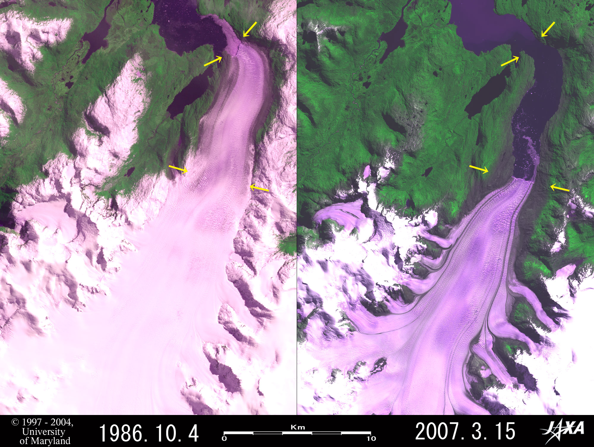  Fig. 1. Retreat of Jorge Montt Glacier
Figure 1 depicts the Jorge Montt Glacier that flows from the Southern Patagonian Ice Field and calves into the Baker Channel. The left image of Fig. 1 was observed by the USA’s Landsat 5 in 1986, and the right one by Japan’s Advanced Land Observing Satellite "Daichi" in 2007. When comparing both images, you will find that the terminus of the glacier retreated as much as 8.5 to 10.6 km during these 21 years and that the water surface progressed into the deep inlet. The pair of images also indicates that the whole glacier including branches became shrunk and the width at the lower arrows decreased greatly from 4.5 km to 1.5 km. There are gray areas in the both sides near the terminus of the retreated glacier, and they seem to be the areas that were once covered by glacier ice but have not yet covered with vegetation after the glacier retreated and the rocks were exposed.  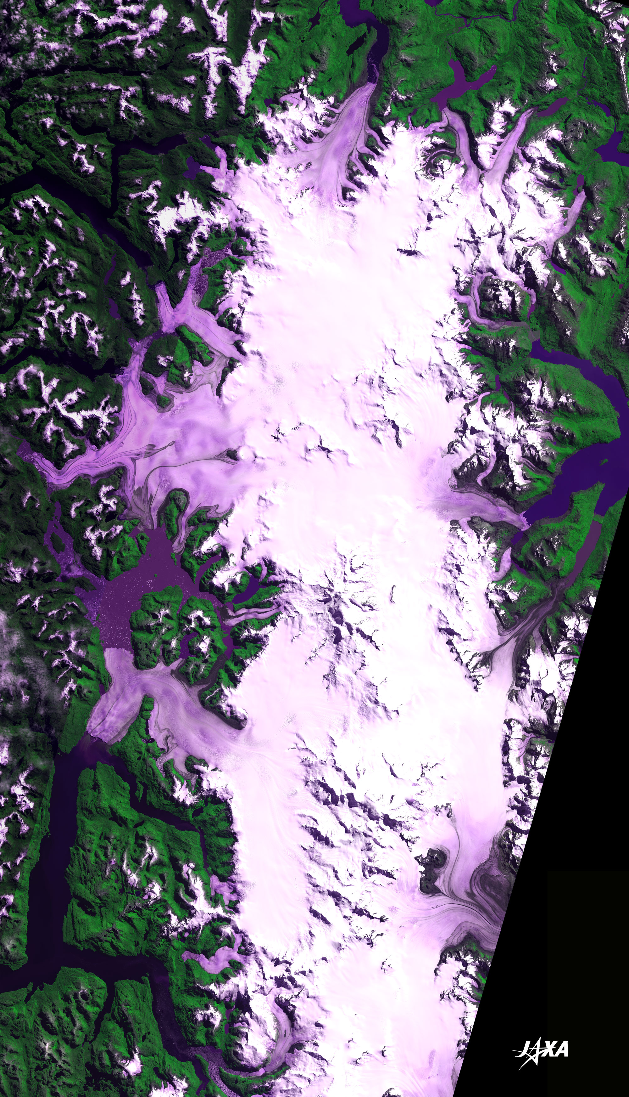
Fig. 2. Wide area image of the northern part of Southern Patagonian Ice Field
Northern Area of Southern Patagonian Ice Field (kmz, 1.07 MB, Low Resolution) as seen on Google Earth. Figure 2 is a wide area image of the northern part of the Southern Patagonian Ice Field that was created by pasting together the images observed by Daichi in September 2006 and in March 2007. The Southern Patagonian Ice Field extends over 90 km from east to west and 500 km from north to south between Chile and Argentina in South America, and appears white or pale purple in this image. Jorge Montt Glacier in Figure 1, one of many glaciers that flow from the ice field, is located in the northernmost tip. When looking at the ice field clockwise from there, you can see O'Higgins Glacier and Viedma Glacier in the east, and Pío XI Glacier, Greve Glacier, Occidental Glacier and Bernardo Glacier in the west, respectively. Among these, Viedma Glacier belongs to Los Glaciares National Park in Argentina but the other glaciers belong to Bernardo O'Higgins National Park in Chile. This national park contains the great part of the Southern Patagonian Ice Field, the archipelago and fjord zone in the west and the area reaches more than 35,000 km2 nearly equivalent to 1/10 of the area of Japan. The southeastern border of the park touches Los Glaciares National Park in Argentina and Torres del Paine National Park in Chile. Out of above-mentioned glaciers, a lot of glaciers are retreating (cf. Fig. 1, Fig. 3 and Fig. 5) but only Pío XI Glacier is advancing exceptionally (cf. Fig. 4). The advance or retreat of the terminuses of glaciers is commonly used as one of indexes of global warming, however, according to Dr. Renji Naruse, who has been studying glaciers in Patagonia for a long time, such changes of glaciers there do not have direct relations with the climate change. It is because the terminuses of all big glaciers in Patagonia flow into fjords (seawater) or lakes (fresh water), and if the frequent calving of the glacial terminus continues with some reason, or if large icebergs are formed after big collapses of glacier tongues, then it is recognized as the retreat of glacier. 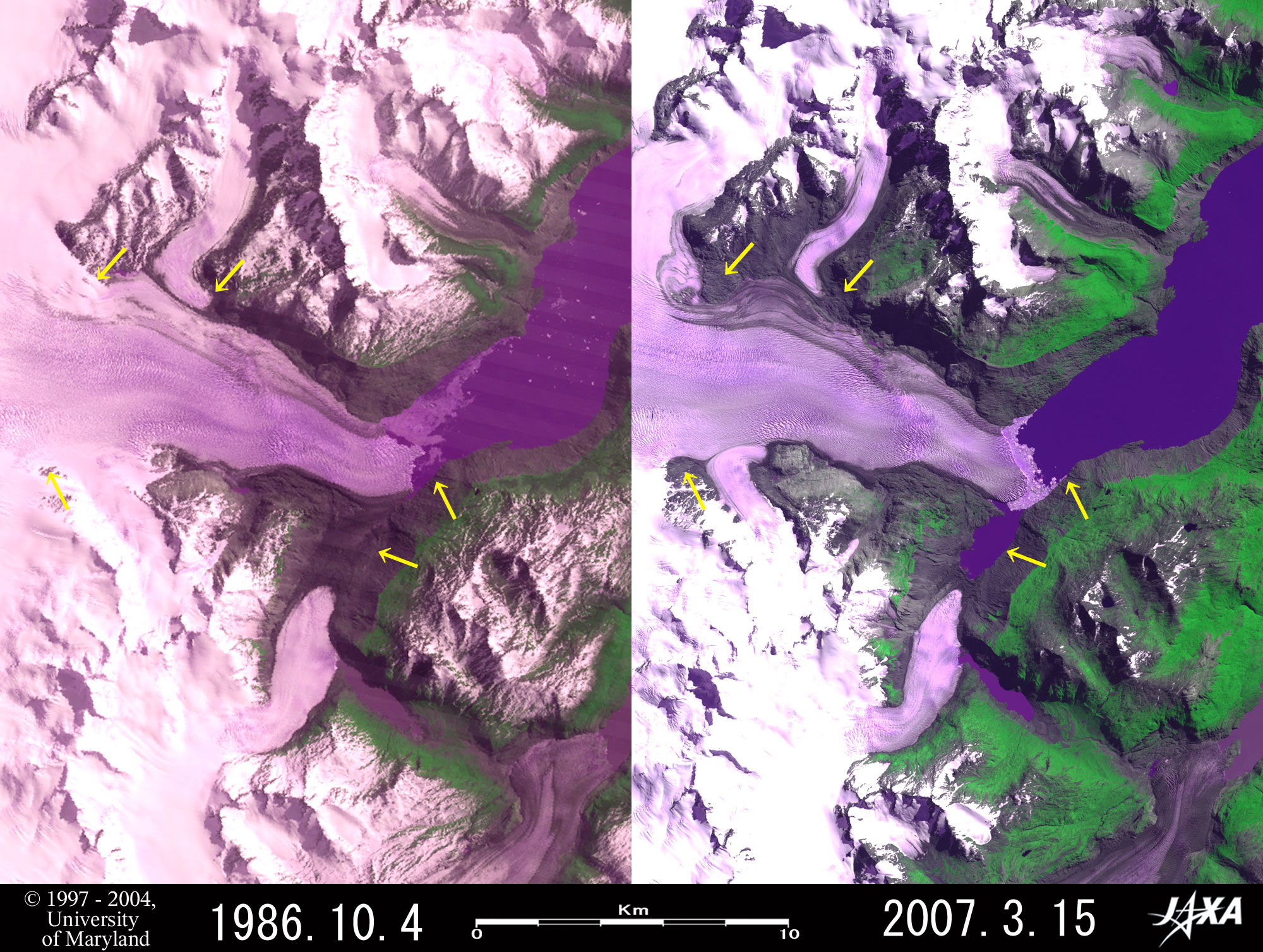  Fig. 3. Retreat of O´Higgins Glacier
Figure 3 indicates O´Higgins Glacier, located in the eastern part of the Southern Patagonian Ice Field and flows into the Lake O´Higgins. You can see that the terminus of the glacier retreated 1.2 km at maximum during 21 years from 1986 to 2007. And Fig. 3 shows that the area, which looks dark brown in the southern side of the terminus of the glacier in 1986 image, was replaced by water surface in 2007 image. Considering this change, it seems reasonable that the brown area in 1986 was the extended branch glacier covered with moraines but it was replaced by water in 2007. Therefore the figure means the terminus of the branch glacier retreated 2.5 km. There are some areas where the glacier became shrunk in the upper stream of O´Higgins Glacier (cf. arrows). The gray areas near the terminus of the glacier and around the glacial lake indicate exposed rocks as Fig. 1.  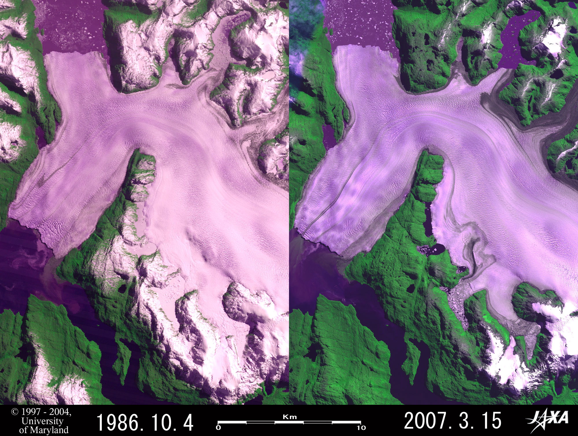 Fig. 4. Advance of Pío XI Glacier
Figure 4 shows Pío XI Glacier, located in the western area of the Southern Patagonian Ice Field. This glacier has a unique shape like a hammer head in the lower stream. The northern terminus calves into Lake Greve and the southern one into Eyre Fjord with both termini separating as much as approximately 15 km. This glacier is the exceptional case because it advanced during these 21 years, being different from many other glaciers in Patagonia. If investigating in detail, you can find that the northern terminus advanced approximately 440 m, the southern one 920 m and the terminus of the branch glacier in midstream 360 m respectively. There are some areas where the color was changed from pale purple indicating snow and ice in 1986 to dark purple indicating water surface in 2007 in front of the terminus of branch glacier and in mid stream (cf. red arrows). But it is considered that they only indicate seasonal change, such as whether the surface of glacial lake is frozen or not, instead of annual change, such as retreat of glacier. This glacier was named after Pope Pius XI (Pío XI in Spanish) who pontificated between 1922 and 1939.  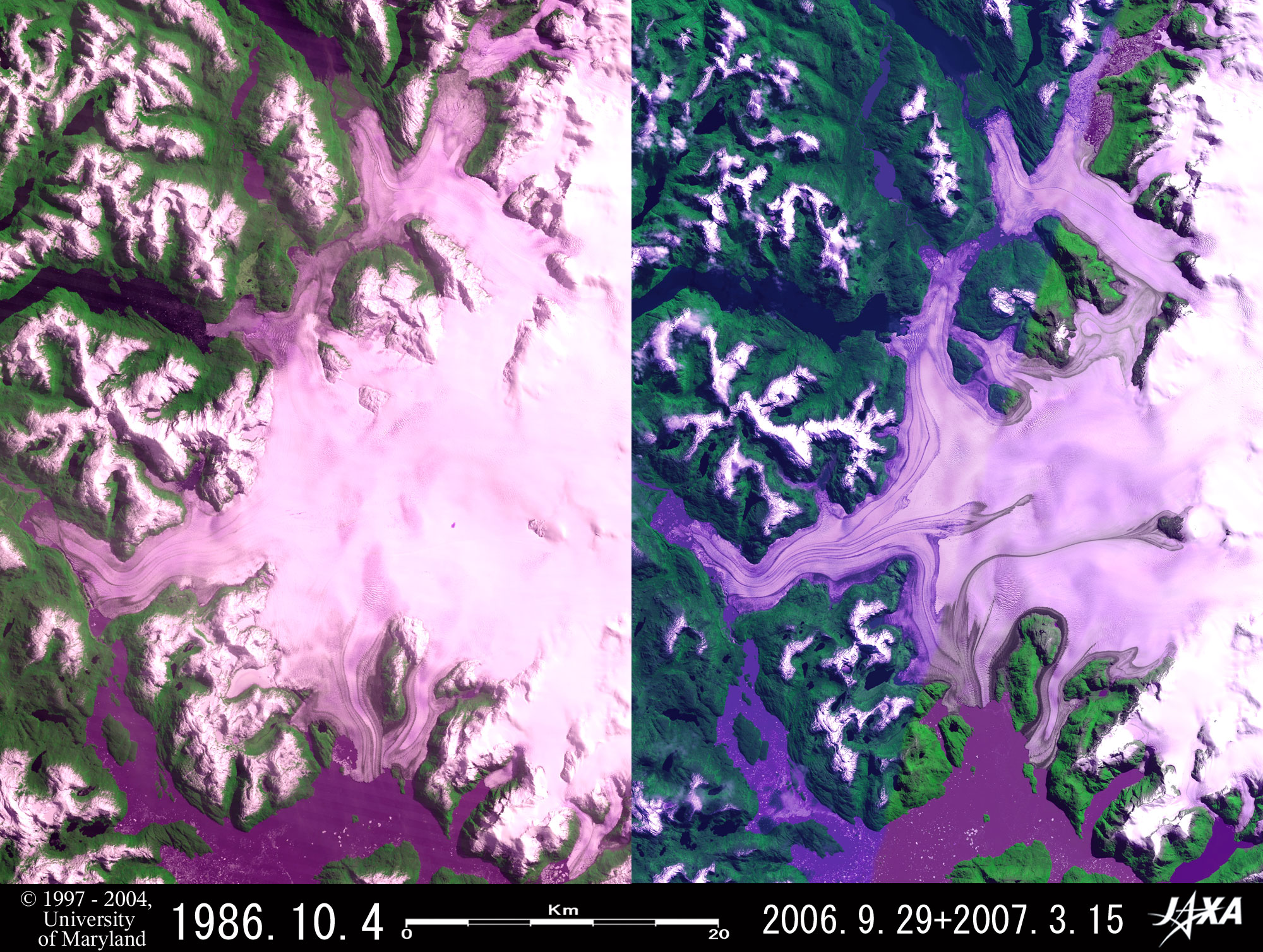 Fig. 5. Retreat of Bernardo, Témpano, Occidental and Greve Glaciers
Figure 5 indicates Bernardo, Témpano, Occidental and Greve Glaciers, located in the western area of the Southern Patagonian Ice Field. You can see that the terminus of Bernardo Glacier retreated as much as approximately 4.5 km during 21 years from 1986 to 2007. Additionally the terminus of Occidental Glacier retreated approximately 1.1 km during 20 years from 1986 to 2006 and the shape of the terminus was broken, the terminus of Témpano Glacier retreated as much as approximately 3.9 km and the terminus of the Greve Glacier retreated as much as approximately 5.5 km. In 2006/2007 image, two glacial lakes can be seen at two red arrows in the northern side of Bernardo Glacier. The glaciers occupying these areas are presumed to have retreated during these 20 to 21 years because the areas look glaciers and icebergs made of broken termini of glaciers in 1986 image. This article benefited from comments and suggestions by Dr. R. Naruse, the chair of Nonprofit Organization (NPO) "Glacier and Cryospheric Environment Research Laboratory" Explanation of the Images: (Right sides of Figs. 1, 3 to 5 and Fig. 2)
AVNIR-2 has four observation bands. These figures were composed by assigning red to visible Band 3 (610 to 690 nm), green to near-infrared Band 4 (760 to 890 nm), and blue to visible Band 2 (520 to 600 nm). The resulting image has natural coloring as if seen by the naked eye. In this image, vegetation is vivid green, clouds, snow, and ice are white, pinkish or pale purple, exposed rocks are dark brown, and water surfaces are black or dark purple. Areas with no data are black. The ground resolution of Figs. 1, 3 and 4 was reduced to 20 m and that of Fig. 2 and Fig. 5 was reduced to 48 m and 40 m respectively to cover a wider area. (Left sides of Figs. 1 and 3 to 5)
Here, we used data downloaded free of charge from the Global Land Cover Facility (GLCF) Earth Science Data Interface operated by the University of Maryland, USA. Related Sites
|


