ページの先頭です。
本文へジャンプする。
【Important Notices】This page is an archive page of information published in the past. Since the update has been completed, it may contain broken links or outdated information. For the latest information, please use the new site Earth-graphy (earth.jaxa.jp).
ここからサイト内共通メニューです。
サイト内共通メニューを読み飛ばす。
サイト内共通メニューここまで。
ここから本文です。

Seen from Space 2007

Splendid blue islands - The Great Barrier Reef, Australia

 
Fig. 1 Great Barrier Reef -- Whitsunday archipelago and Vicinity
Great Barrier Reef (kmz,1.78MB,Low Resolution) is seen from Google Earth.
Figure 1 depicts a part of the Great Barrier Reef located off the coast of Queensland northeast of Australia as observed by the Advanced Visible and Near Infrared Radiometer-2 (AVNIR-2) on board the Advanced Land Observing Satellite (ALOS) Daichi in October and November 2006. The Great Barrier Reef consists of 3,000 large and small coral reefs and more than of 900 islands. It extends over 2,000km from north to south, from the Torres Strait South of New Guinea Island to Bundaberg, Australia, and has a maximum width of 80km.
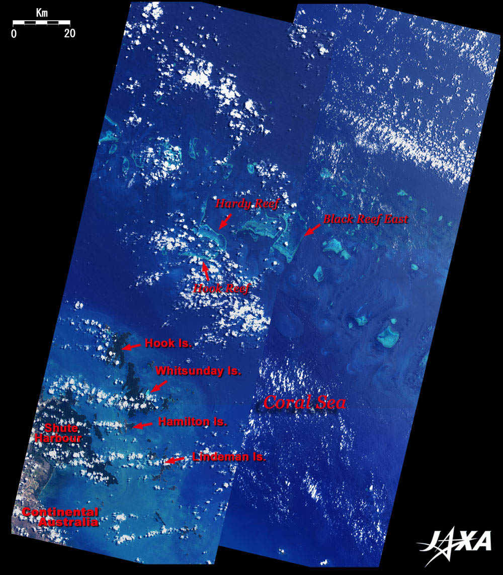
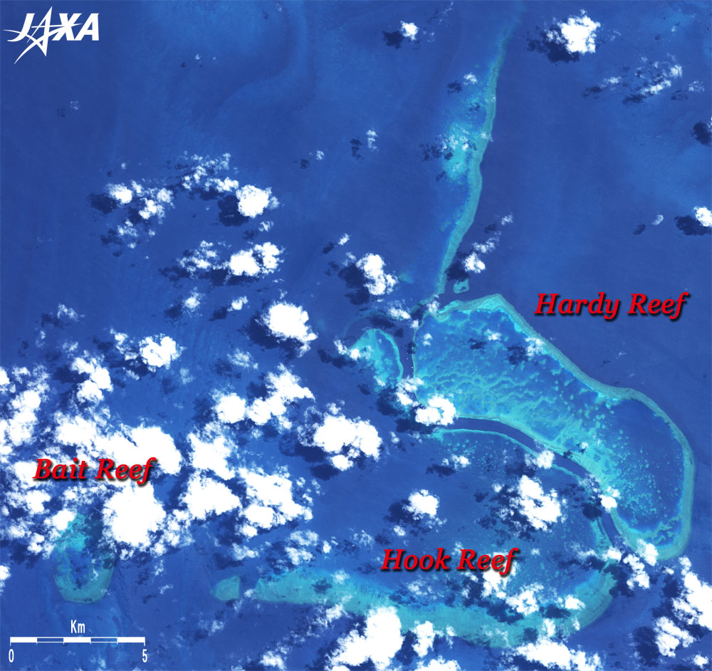
Coral is a marine animal species similar to the sea anemone. Some types of coral, reef-building coral, form a hard skeleton of calcium. The Great Barrier Reef, which is visible from space because of the aggregation of coral skeletons, is biggest life of the Earth.
The Great Barrier Reef is a coral reef lying off Australia's east coast as if protecting it. Captain Cook (a Navy Lieutenant on that voyage) had been struggling to reach the continent when he discovered the Great Barrier Reef in 1770.
The Great Barrier Reef consists of four sections from north to south, the Far North, Cairns, Central, Mackay and Capricorn. Figure 1 depicts the vicinity of Whitsunday archipelago in the Central section. The archipelago, consisting of 74 islands, is located in the center of Queensland State, 1,100km north of Brisbane, the capital of Queensland State, and 700km south of Cairns, a major city of Queensland. It takes one and a half hours to fly from either Brisbane or Cairns by jet. Driving takes 13 hours from Brisbane or 8 hours from Cairns along the scenic Bruce Highway with its beautiful view of the Australian landscape. Brisbane and Cairns are not visible in this figure.
Many places in the Great Barrier Reef are designated as Australian national parks and are protected; these places were registered as world natural heritage sites in 1981. All four criteria for selection as a natural heritage site were satisfied. The Great Barrier Reef is a true treasure of the Earth. In July 2004, the Australian government increased the protected area in the Great Barrier Reef, from 4.5% to 33.3%.

Fig. 2 Whitsunday Island, Hamilton Island, and their Vicinities
White Heaven Beach on Whitsunday Island (center of Fig. 2) is called one of the most beautiful sandy beaches in the world. The fantastic view formed with the green wildwood, with a 6km long white sandy beach sprinkled with white powder beads set off by the emerald green of the coral reefs and sparkling like a jewel.
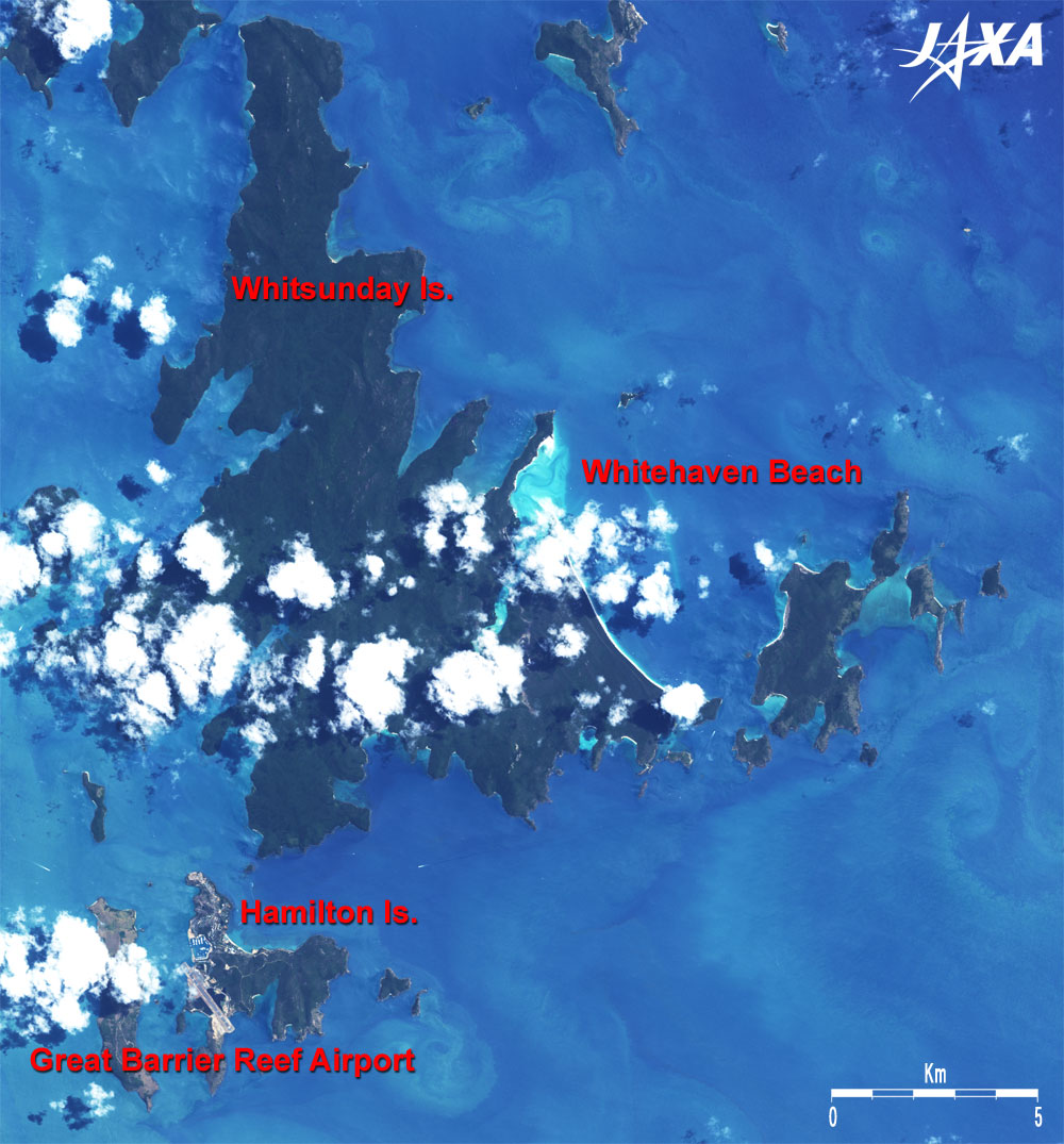
The bottom of Fig. 2 depicts Hamilton Island when it opened in 1964 as a residence area and resort area. Even now, about 70% of the island is protected as a national park. There are only 20 resorts on the Great Barrier Reef. The Great Barrier Reef Airport on the island is the only airport that can accommodate jet airplanes on Great Barrier Reef. There are direct flights from Sydney, Melbourne, Brisbane and Cairns and ships from Shute Harbour on continental Australia.

Fig. 3 Hardy Reef and its Vicinity
Figure 3 depicts the area around Hardy Reef, including Hook Reef, which has the shape of a fishhook. There is also Heart Reef, one of the three heart-shaped islands in the world (actually Heart Reef is not an island, but a reef), on the south edge of the beautiful Hardy Reef east of Whitsunday archipelago. It is very small and not clearly visible in the figure, but people who visited there found a small heart-shaped coral reef. (Hint: It stands alone in the inland sea surrounded by a coral reef.)

Most coral in the Great Barrier Reef live in the area at the upper limit of the water temperature tolerance. Coral bleaching (1) in the Great Barrier Reef was induced by global warming from 1998 to 2002. We should endeavor to limit global warming in order to preserve the beautiful natural environment for the future.
Using Earth-observation satellites, it is possible to monitor the trend of coral bleaching by periodically observing the coral reefs.


1. Photosynthesizing zooxanthella live inside the coral. The coral bleaching phenomenon is caused by stress from sea temperature increases. The coral expels the zooxanthella, turns white, and finally dies. If the sea-surface temperature rises from 2 to 6, less than 5% of the current reef of the Great Barrier Reef will survive.

Explanation of the Images:
Figs. 1 to 3
Satellite: Advanced Land-Observing Satellite (ALOS) (Daichi)
Sensor: Advanced Visible and Near Infrared Radiometer-2 (AVNIR-2)
Date: 0020 (UTC) on October 7, 2006
Ground resolution: 10 m
Map Projection: Universal Transversal Mercator (UTM)
AVNIR-2 has four observation bands. The composite image is usually produced by assigning red to Band 3 (610 to 690nm), green to Band 2 (520 to 600nm), and blue to Band 1 (420 to 500nm). The resulting image has natural coloring as if seen by the naked eye. Thus the ground objects are distinguished by the following colors.
Deep green: Forest
Charcoal grey: Savanna
Gray: Urban area, runway
Blue: Deep ocean
Bright blue: Shallow water
Light blue: Coral reef
White: Cloud
Black: Area with no data

Related Sites:
ALOS Research and Application Page
Maldives - A Pearl Necklace in the Indian Ocean
Special Feature on Coral Reef -Part 2- Can a Satellite Detect Coral Reef Distribution?
Special Feature on Coral Reef -Part 1- What is Going on with the Coral Reef?
Ocean, Seen from Space
本文ここまで。
image:Satellite Navigator
image:Satellite Applications and Operations Center(SAOC)
Earth Data Collection by JAXA Satellites
image:ページTOP