| |
 |
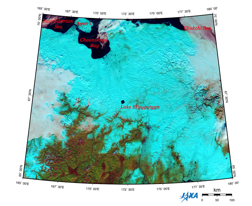
| Fig. 1 Location of Lake El'gygytgyn |
Figure 1 depicts Lake El'gygytgyn located in Chukotka district in the eastern end of northeastern Siberia as observed by GLI in October 2003. The black areas on the upper side of the figure are the East Siberian Sea and the Chukchi Sea, parts of the Arctic Ocean. Most of the land area looks light blue indicating snow cover. The forest (olive green) and the bare land (auburn) can be seen on the bottom of the figure.
 |
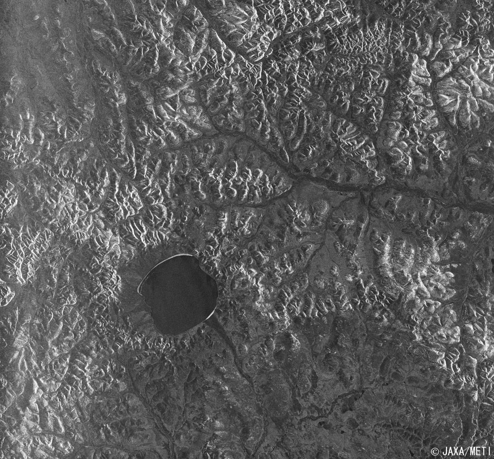
| Fig. 2 Lake El'gygytgyn and Vicinity |
Figure 2 depicts Lake El'gygytgyn and the vicinity as observed by the Synthetic Aperture Radar (SAR) aboard Japanese Earth Resources Satellite-1 in October 1992. The shape of Lake El'gygytgyn resembles a tadpole that has a tail attached to the goldfish basin. The river that extends like the tail is the Enmyvaam River that is the only river pouring off the lake. This river joins the Yurumkuveyem River in the upper right and becomes the Balaya River and then the Anadyr River and flows into the Anadyr Bay, which connects with the Bering Sea. This image indicates the strength of the radar signal reflected by the ground to the SAR. Because the radar signal from the SAR is transmitted to the right side in the direction of satellite movement, the slopes on the southeastern side look bright in Fig. 2. Considering that the observation swath width is 75 km, you can find that the lake is approximately 12 km in diameter. The shores on the northwestern side and the southeastern side of the lake seem to be frozen.
The scientists know that the lake was formed by the impact of a meteorite.
| Crater |
Diameter |
Created Era |
Remarks |
| El'gygytgyn |
18 km |
3.5±0.5 Million years ago (Tertiary Pliocene) |
Russia |
Source: Earth Impact Database maintained by the University of New Brunswick in Canada
The major features of Lake El'gygytgyn are as follows, according to the following references.
| · |
The lake is 175 m deep with a volume of 14 cubic km and is covered with ice every year from the end of October to the beginning of June. |
| · |
The lake surface is 492 m above sea level, and the highest point of the crater rim is 906 m above sea level. |
| · |
The crater was formed 3.6 million years ago. |
| · |
It is an oligotrophic lake inhabited by rockfish. |
Previous surveys indicate that the lake have never been parched nor covered with a glacier since its formation, so layers of sediment more than 350 m thick formed in the bottom of the lake and have recorded the paleoenvironment continuously without disturbance for over 3.6 million years. This is the only such land record in the Arctic Circle. Therefore, in order to promote better understanding on the role of the Arctic Circle in the Earth's climate system, an international research team consisting of researchers from the US, Germany, and Russia gathered bottom core samples of the lake in 1998, 2000 and 2003, and they are planning to excavate in spring of 2006 in the next place. The results for analysis of samples dating back 300,000 years have been published.
Two to three million years ago when global cooling started, an ice sheet developed in the Northern hemisphere, and the Arctic Circle evolved from a warm forest ecosystem to a permafrost ecosystem. Therefore, one of the most valuable research themes is to clarify why and how these phenomena took place. Additionally, it is expected that new knowledge about the formation of the impact crater may be acquired because the landform of the crater has been preserved well.
References:
 International Continental Drilling Program (ICDP), El'gygytgyn Lake Workshop Report, 2001 International Continental Drilling Program (ICDP), El'gygytgyn Lake Workshop Report, 2001
Matt Nolan, et al, Analysis of lake ice dynamics and morphology on Lake El'gygytgyn,NE Siberia, using synthetic aperture radar (SAR) and Landsat, Journal of Geophysical Research, Vol. 108, No. D2, 2003
Lake El'gygytgyn Drilling Project (ICDP Homepage)
|
Explanation of the images:
Fig. 1
| Satellite: |
Advanced Earth Observing Satellite - II (ADEOS-II) (Midori - II) |
| Sensor: |
Global Imager (GLI) |
| Date: |
October 5, 2003 |
| Ground resolution: |
250 m |
| Map projection: |
Albers Equal-Area Conic |
This special color composition was made by using GLI 250 m resolution channels, and assigning red to mid-infrared channel 29 (2,210 nm), green to near-infrared channel 23 (825 nm) and blue to visible channel 21 (545 nm). In this image, you can interpret the image as follows.
|
| Green |
Vegetation |
| Black or dark blue: | Water surfaces |
| Red, brown or pink: | Deserts, soil or burn scars (no vegetation) |
| White: | Clouds |
| Light blue: | Snow and ice |
Fig. 2
|
 |
|