| |
 |
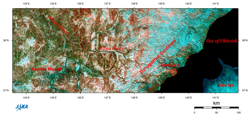
| Fig. 1. Location of the Sea of Okhotsk and the Konder Massif |
Figure 1 depicts the area of Siberia facing the northwestern Sea of Okhotsk as observed by GLI in April 2003. Sea ice still remains in the lower right portion of the image. The steep Dzhugdzhur cordillera is covered with snow in the coastal region. Because of this cordillera, the Maya River cannot flow into the Sea of Okhotsk, so it flows north and joins the Ardant River then the Lena River and then flows into the Arctic Ocean. On the left of the figure, you can see the Konder Massif, which resembles a lunar crater. The Konder Massif is located 1,200 km north of Khabarovsk, the central city of the Far Eastern portion of Russia, and is 500 km southeast of Yakutsk, an extremely cold place.
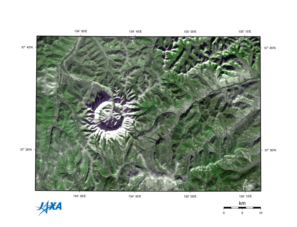 |
| Fig. 2. The Konder Massif and vicinity |
Figure 2 depicts the Konder Massif and vicinity observed by AVNIR in January 1997. The Konder Massif looks white from snow cover, and the circumference is the comparatively gentle mountainous region covered with forest. The northern side of the outer rim on the Konder Massif breaks off, and the river pours out from there. Because the sunlight is from the southeast (lower right), shade is formed on the northwestern (upper left) side. The diameter of the Massif ridge on the outer rim is 9 km, and the diameter including its flanks is 14 to 18 km (see the scale bar in the lower right). According to the detailed map, the highest point is 1,256 m above sea level, and the height from the base of the crater is 350 m.
 |
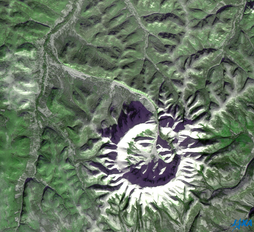
Fig. 3. Expanded image of Konder Massif
(The upside-down image is here.) |
Figure 3 is a partially expanded image of Fig. 2. The low, flat area inside the Konder Massif appears to be a glacier with a rough surface. The purplish area on the outer rim of the broken off portion may be a glacial lake. You can see some roads near the river extending from the northern side of the Konder Massif to the northwest. They connect with the mine, where platinum and gold ore were discovered in 1989. The platinum deposit is the second largest in Russia.
The origin of the Konder Massif, is not yet understood. It is not known whether the crater was formed by the impact of a meteorite or an ancient volcano. Konder Massif is not yet carried in the Earth Impact Database managed by the University of Nouveau-Brunswick in Canada.
Because the sunlight shines on objects from below, the inside of the Konder Massif may look as if it is protruding like a plateau. If you see the upside-down image (or invert Fig.3), the outer rim will look raised and the inside will look hollow.
Explanation of the images:
Fig. 1
| Satellite: |
Advanced Earth Observing Satellite - II (ADEOS-II) (Midori - II) |
| Sensor: |
Global Imager (GLI) |
| Date: |
April 6, 2003 |
| Ground resolution: |
250 m |
| Map projection: |
Mercator |
|
This special color composition was made by using GLI 250 m resolution channels, and assigning red to mid-infrared channel 29 (2,210 nm), green to near-infrared channel 23 (825 nm) and blue to visible channel 21 (545 nm). In this image, you can interpret the image as follows.
|
| Green: | Vegetation |
| Black or dark blue: | Water surfaces |
| Red, brown or pink: | Deserts, soil or burn scars (no vegetation) |
| White to blue: | Snow and ice |
Figs. 2 and 3
| Satellite: |
Advanced Earth Observing Satellite (ADEOS) |
| Sensor: |
Advanced Visible and Near-Infrared Radiometer (AVNIR) |
| Date: |
January 22, 1997 |
| Ground resolution: |
16 m |
| Map projection: |
Universal Transversal Mercator (UTM) |
|
The color composition was made by using three out of four AVNIR bands: visible 610 to 690 nm (band 3) for red, near infrared 520 to 600 nm (band 2) for green and visible 420 to 500 nm (band 1) for blue. As a result, the figures have a natural coloring, with vegetation slightly emphasized. In these images you can interpret the images as follows.
|
| Green: | Forests or grasslands |
| Gray: | Snow, shore of river, or roads |
| White: | Snow or ice |
| Black: | Water surface or dark shade |
|
 |
|