Seen from Space 2004
Circular Farms and Impact Craters in the Sahara
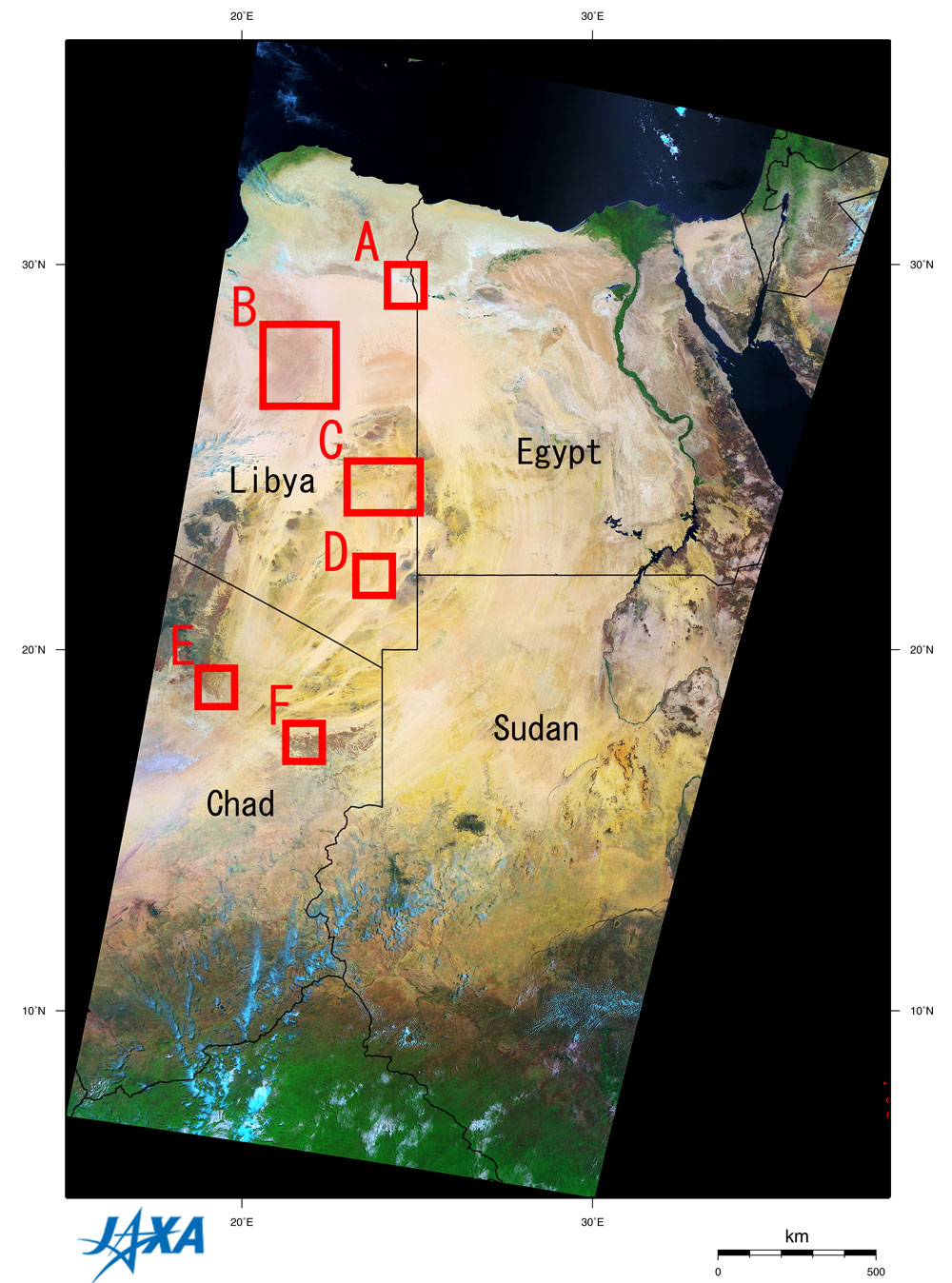
Figure 1 depicts the eastern part of the Sahara observed by GLI in May 2003. This image covers Egypt, Sudan, Chad (clockwise) and Libya in the center. The Nile is on the right side and a thick tropical forest at the bottom. Because the original ground resolution of this image is 250 m, you can see some very interesting points when you expand this image. In eastern Libya, in the center of Frame A, is the Al Jaghbub Oasis. It is 48 km in the east - west direction and 22 km in north - south direction. Black represents the water surface, green represents vegetation and light blue is considered to be salt on the ground. Frame B covers lowlands in eastern Libya and depicts many folds of sand dunes on the right side. Red dots and dark brown smoke that look like burning exhaust gas from oil wells or natural gas fields is also on the right side. A road runs in a north - south direction in the center, with green and dark brown dots regularly forming lines. Each dot is a farm measuring approximately 1 km in diameter that is cultivating wheat and alfalfa (*1). There is a well at the center of each circular farm, with a sprinkler 500 m long that rotates slowly and irrigates the farm. This is called pivot irrigation. Each different colored dot reflects the different growth status of each farm's produce. The ground water drawn from the wells is rainwater that fell 10 thousand years ago when the climate of the Sahara was far wetter than it is at the present and has been sealed in an aquifer (*2). It is also called fossil water (*3). Rain water that falls in the Sahara at present is not sufficient at all to supplement the ground water, so ground water resources are depleting rapidly. Some researchers predict that the wells in southern Libya will dry up in 40 to 60 years. You can find the Al Kufrah Oasis and neighboring clusters of small green and dark brown circles in the shape of a wooden horse in southeastern Libya on the left side of Frame C. They are also circular farms with pivot irrigation. The African continent is very old, having been formed by the breakup of Gondwana, a super continent, 180 to 90 million years ago. Gondwana already existed 600 million years ago (around the end of the Pre-Cambrian). As you can see in this GLI image in Frames C to F, there are some meteorite impact craters in this area,. These craters are clearly visible since there is no vegetation in the desert. Over the course of time their shapes have changed due to its geology, subsequent diastrophism, weathering and erosion, etc. The following table shows the craters in the order of the era they were created.
Source: Earth Impact Database maintained by the University of New Brunswick in Canada (*1) Alfalfa: World's most valuable forage, Medicago sativa, known also as lucerne. It is grown for hay, pasture, and silage. (Source: McGraw-Hill Concise Encyclopedia of Science & Technology) (*2) Aquifer: a subsurface zone that yields economically important amounts of water to wells. The term is synonymous with water-bearing formation. An aquifer may be porous rock, unconsolidated gravel, fractured rock, or cavernous limestone. (Source: McGraw-Hill Concise Encyclopedia of Science & Technology) (*3) Fossil water: The water that is sealed in an aquifer and does not take part in the hydrologic cycle.
Related sites: - From the cradle of mankind to the oldest desert - |
||||||||||||||||||||||||||||||||||||||