High-level Image Processing and Analysis
 This is a necessary technique to handle and analyze satellite
images, which includes development and precision of methodology
to evaluate accuracy and image quality, and evaluation of the
data conducting multivariate analysis. The examples are as follows.
This is a necessary technique to handle and analyze satellite
images, which includes development and precision of methodology
to evaluate accuracy and image quality, and evaluation of the
data conducting multivariate analysis. The examples are as follows.
- Development of geometric correction method
- Development of radiometric correction method
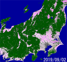
- Algorithm development to generate a digital elevation model (DEM) and ortho rectification
- Development of image quality evaluation method
- Development of multivariate analysis method
- Algorithm development to analyze multi-sensor data
Global Environmental Issue Analysis
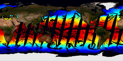
 This is to develop an algorithm for analysis of satellite data to monitor
parameters, which affects global environmental issues, and analysis of
spatial and temporal distributions of derived geophysical parameters to
evaluate effects on the global environment.
This is to develop an algorithm for analysis of satellite data to monitor
parameters, which affects global environmental issues, and analysis of
spatial and temporal distributions of derived geophysical parameters to
evaluate effects on the global environment.
- Algorithm development of geophysical parameters and analysis of their
spatial and temporal distributions
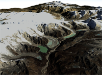
- Soil moisture, snow parameters, glaciers, permafrost, agriculture parameters, forestry, forest fires, desertification, etc.
- Analysis of snow conditions e.q. snow diameter, temperature and contamination
- Evaluation of methodology to evaluate long-term variability
- Algorithm development to monitor sea ice distribution and variation
- Development of evaluation method of environmental stress