AMSR-related Satellite Catalog:
GOSAT-GW (AMSR3 mounted)
Get to know AMSR and satellites -- Advanced Microwave Scanning Radiometer AMSR series
  • Global Observing Satellite for Greenhouse Gases and Water Cycle
    GOSAT-GW (AMSR3 mounted)
    [Under Development]
  • Global Change Observation Mission - Water "SHIZUKU"
    GCOM-W (AMSR2 mounted)
    [In Operation]
  • NASA Aqua Satellite
    Aqua (AMSR-E mounted)
    [AMSR-E Operation Completed]
  • Advanced Earth Observation Satellite-II "Midori II"
    ADEOS-II (AMSR mounted)
    [Operation Completed]
  • Marine Observation Satellite MOS-1 / MOS1b
    MOS-1 / MOS-1b (MSR mounted)
    [Operation Completed]
  • AMSR-related Satellite Catalog
  • GOSAT-GW
  • Overview

Global Observing Satellite for Greenhouse Gases and Water Cycle
GOSAT-GW (AMSR3 mounted)

Mission

AMSR-E

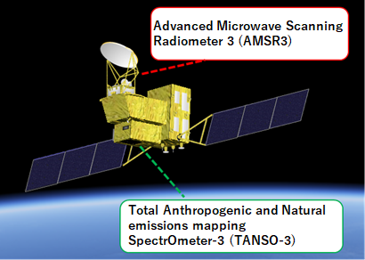
The Global Observing SATellite for Greenhouse gases and Water cycle (GOSAT-GW*1) is an Earth observation satellite that is responsible for the greenhouse gases observation missions (led by the Japanese Ministry of the Environment and the National Institute for Environmental Studies) and the water cycle variation observation missions (led by JAXA). In order to continue and expand missions on the water cycle variation observation by SHIZUKU (GCOM-W*2, launched in 2012) and on the greenhouse gases observation by IBUKI (GOSAT*3, 2009) and IBUKI-2 (GOSAT-2*3, 2018), GOSAT-GW will carry two successor sensors, the Advanced Microwave Scanning Radiometer 3 (AMSR3) developed by JAXA, and the Total Anthropogenic and Natural emissions mapping SpectrOmeter-3 (TANSO-3) developed by JAXA under contract with the Ministry of the Environment. Mitsubishi Electric Corporation is selected as the primary manufacturer of the satellite and its onboard sensors.

  1. GOSAT-GW: The Global Observing SATellite for Greenhouse gases and Water cycle
  2. GCOM-W: The Global Change Observation Mission – Water
  3. GOSAT: The Greenhouse gases Observing SATellites

Mission Instrument

Advanced Microwave Scanning Radiometer 3 (AMSR3)

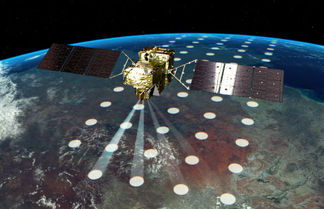
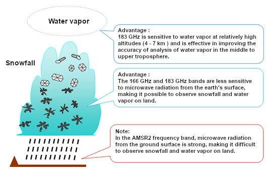
AMSR3 is a sensor that observes microwaves naturally emitted from the earth's surface, ocean surface, and atmosphere. AMSR3 enhances the observable wavelength band from AMSR2 on GCOM-W to enable observations of snowfall and water vapor on land.

AMSR3 Technology
AMSR3 Technology

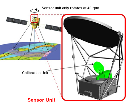
The Advanced Microwave Scanning Radiometer 3 (AMSR3) to be mounted on GOSAT-GW is the successor to the AMSR2 sensor mounted on GCOM-W, and aims to achieve the world's top performance and functionality as a microwave radiometer. Microwave radiometers can observe physical quantities related to water on the ground surface, sea surface, and in clouds through the clouds. AMSR3 is also capable of nighttime observations, making it possible to perform observations at any time of the day or night, regardless of weather conditions. AMSR3 is equipped with the new 166 GHz and 183 GHz bands, which will improve the accuracy of analysis and enable observations of snowfall and water vapor on land.

AMSR-E
AMSR-E

Total Anthropogenic and Natural emissions mapping SpectrOmeter-3 (TANSO-3)

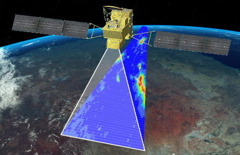
TANSO-3, which is being developed by the Ministry of the Environment, is the successor sensor to TANSO-FTS-2 *4 installed on "IBUKI-2". By replacing the Fourier interferometric spectrometer used in TANSO-FTS-2 with a new diffraction grating spectrometer, TANSO-3 will be able to observe more spatially detailed greenhouse gases such as carbon dioxide (CO2) and methane (CH4). TANSO-3 will also newly observe nitrogen dioxide (NO2).

  1. TANSO-FTS-2: Thermal And Near infrared Sensor for carbon Observation - Fourier Transform Spectrometer-2
TANSO-3 Technology
TANSO-3 Technology

TANSO-3, which will be mounted on GOSAT-GW, is the successor to TANSO-FTS-2, which was mounted on IBUKI-2, and will contribute to improving the accuracy of estimating greenhouse gas emissions by observing a wide range of greenhouse gases on the earth with high accuracy. The main feature of TANSO-3 is that it adopts a new diffraction grating spectroscopy method instead of the Fourier interferometric spectroscopy method used in TANSO-FTS and TANSO-FTS-2. This new grating type spectroscopy method enables observation over an area, whereas the previous method was based on a grating of points, and thus enables more observation data to be acquired. TANSO-3 is equipped with two observation modes: wide-area observation mode and precise observation mode. The wide-area mode enables areal observations with a resolution of 10 km over a swath of more than 911 km, while the precise mode enables detailed observations with a resolution of 3 km over a swath of more than 90 km.

GOSAT-2
GOSAT-2
GOSAT-GW
GOSAT-GW
  • AMSR-related Satellite Catalog
  • GOSAT-GW
  • Specification

Global Observing Satellite for Greenhouse Gases and Water Cycle
GOSAT-GW (AMSR3 mounted)

Satellite specifications

Satellite specifications
                     
Spacecraft launch mass Approx. 2600 kg (including approx. 300 kg of expendable fuel)
Power generation Approx. 5.3 kW
Shape 2 box shape with wing-type solar array paddles
Approx. 5.1m × 23.5m × 5.1m (on-orbit configuration)
Designed lifetime 7 years
Orbit Type Sun-synchronous sub-recurrent
Altitude 666 km (same as GOSAT)
Local sun time (at ascending node) 13:30 +/- 15min (same as GCOM-W)
Inclination angle 98.08 deg
Cycle 98.2min
Revisit period 3 days (same as GOSAT)
Number of orbits 44 orbits/cycle
Launch date Japanese fiscal year 2025 (scheduled)
Launch location Tanegashima space center, JAPAN
Launch vehicle H-IIA launch vehicle

AMSR3 specifications

AMSR3 specification
          
Scan rate Conical scan at 40 rpm
Antenna Offset parabola with 2.0 mφ
Swath width Approx. 1535 km (nominal) with 666-km altitude and 55.0-degree incident angle
Digitization 12 bits
Dynamic range 2.7 ~ 340 K
Polarization Vertical (V) and Horizontal (H)
AMSR3 channel set
Center frequency Bandwidth
(nominal)
Polarization Temperature resolution
(at 150-K observation)
Beam width
(nominal)
Ground resolution
(nominal)
Sampling interval
(scan direction)
Incident angle
6.925 GHz 350 MHz H/V < 0.34 K 1.8° 33 km x 57 km 8 km Approx. 55°
7.3 GHz 350 MHz H/V < 0.43 K 1.8° 33 km x 57 km 8 km Approx. 55°
10.25 GHz 500 MHz H/V < 0.33 K 1.2° 22 km x 38 km 8 km Approx. 55°
10.65 GHz 100 MHz H/V < 0.70 K 1.2° 22 km x 38 km 8 km Approx. 55°
18.7 GHz 200 MHz H/V < 0.70 K 0.65° 12 km x 21 km 8 km Approx. 55°
23.8 GHz 400 MHz H/V < 0.60 K 0.75° 14 km x 24 km 8 km Approx. 55°
36.42 GHz 840 MHz H/V < 0.70 K 0.35° 6 km x 11 km 8 km Approx. 55°
89.0 GHz A/B 3000 MHz H/V < 1.20 K 0.15° 3 km x 5 km 4 km Approx. 55°/Approx. 54.5°
165.5 GHz 4000 MHz V < 1.50 K Az: 0.23°
El: 0.30°
4 km x 9 km 8 km Approx. 52°(reference)
183.31 +/- 7 GHz 2000 x 2 MHz V < 1.50 K Az: 0.23°
El: 0.27°
4 km x 8 km 8 km Approx. 52°(reference)
183.31 +/- 3 GHz 2000 x 2 MHz V < 1.50 K Az: 0.23°
El: 0.27°
4 km x 8 km 8 km Approx. 52°(reference)

Comparison of GOSAT-GW with ADEOS-II, Aqua and GCOM-W

                  
Satellite ADEOS-II Aqua GCOM-W GOSAT-GW
Satellite operator NASDA NASA JAXA JAXA
On-board instrument AMSR
GLI
ILAS-II
SeaWinds
POLDER
AMSR-E
AIRS
AMSU
HSB
CERES
MODIS
AMSR2 AMSR3
TANSO-3
Orbit Sun-synchronous orbit Sun-synchronous orbit Sun-synchronous orbit Sun-synchronous orbit
Altitude (on Eq.) 803 km 705 km 699.6 km 666 km
Local sun time 10:30
(at descending node)
13:30
(at ascending node)
13:30
(at ascending node)
13:30
(at ascending node)
Launch 14 Dec. 2002 4 May. 2002 18 May. 2012 JFY2025(scheduled)
Designed lifetime 3 years 6 years 5 years 7 years
Status Stopping all missions
in Oct. 2003
In operation
(AMSR-E stopped in Oct. 2011)
In operation Under development

Comparison of AMSR3 with AMSR, AMSR-E and AMSR2


Sensor AMSR AMSR-E AMSR2 AMSR3
Satellite ADEOS-II Aqua GCOM-W GOSAT-GW
Swath width 1600 km 1450 km 1617 km 1530 km
Frequency (GHz) 6.9, 10, 18,
23, 36, 50, 52, 89
6.9, 10, 18,
23, 36, 89
6.9/7.3, 10.65,
18, 23, 36, 89
6.9/7.3, 10.25/10.65,
18, 23, 36, 89, 166,
183 +/- 7 [176 & 190],
183 +/- 3 [180 & 186]
Antenna size 2.0 m 1.6 m 2.0 m 2.0 m
Spatial resolution 40 x 70 km @ 6.9 GHz
8 x 14 km @ 36 GHz
43 x 75 km @ 6.9 GHz
8 x 14 km @ 36 GHz
35 x 62 km @ 6.9 GHz
7 x 12 km @ 36 GHz
34 x 58 km @ 6.9 GHz
7 x 11 km @ 36 GHz