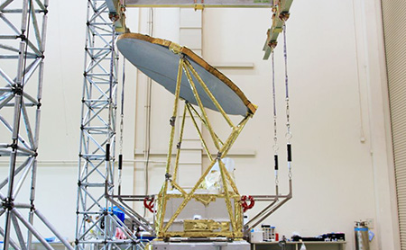
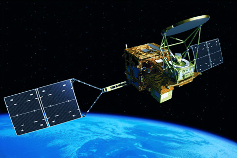
Global Change Observation Mission - Water "SHIZUKU" GCOM-W (AMSR2 mounted)
Mission
The Global Change Observation Mission (GCOM) is a satellite project that aims to observe global environmental changes on Earth from space over a long period of time. GCOM-W "SHIZUKU" is responsible for observations related to the water cycle.
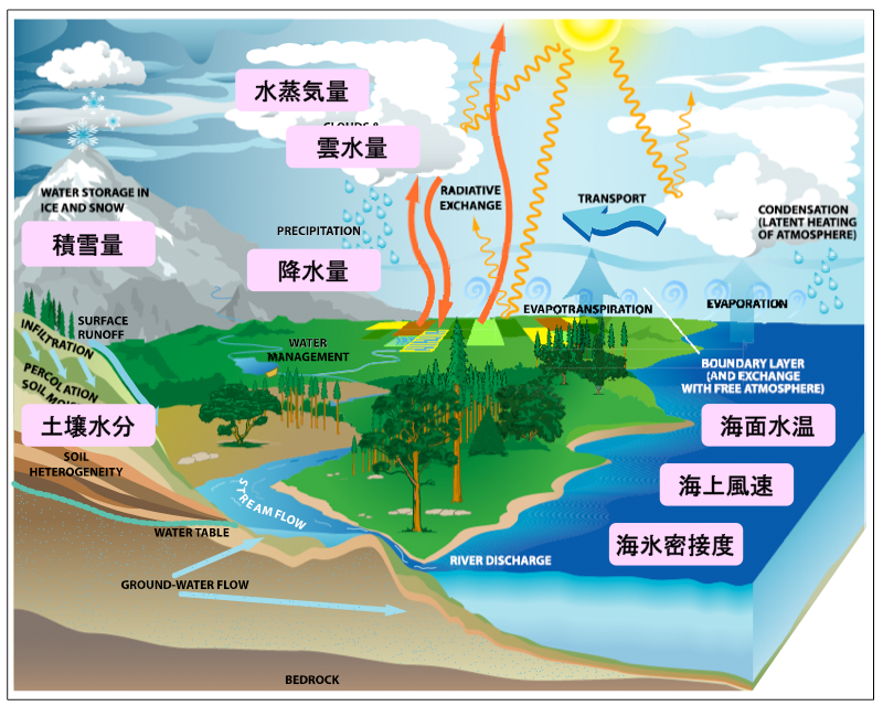
Since water on the earth plays an important role in the process of energy redistribution from the sun, a detailed study of water movement is essential to improve the prediction accuracy of climate change. The high-performance observation instrument (AMSR2) onboard GCOM-W has a large antenna with a diameter of about 2 m and can catch faint microwaves emitted from sea surface temperature, ocean wind speed, and water vapor in the atmosphere from an altitude of about 700 km. By analyzing these weak microwaves, we aim to elucidate climate change that causes extreme weather events using a variety of information.
-
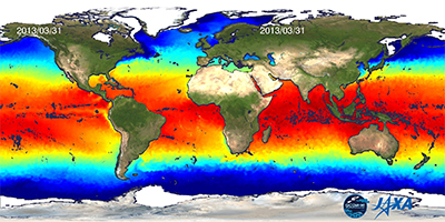
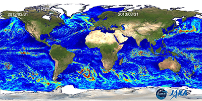
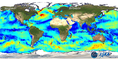
Sea Surface Temperature
-
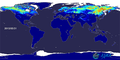
Snow Depth
-
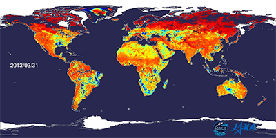
Soil Moisture Content
-
Precipitation
-
Cloud Liquid Water Content
-
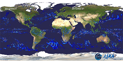
Sea Surface Wind Speed
about GCOM-W
GCOM-W will construct and demonstrate the use of a global-scale, long-term, continuous observation system that will provide the observational data necessary to elucidate the mechanisms of climate and water cycle change.
Specifically, GCOM-W will focus on the following areas: (1) changes in the cryosphere, including sea ice, ice sheets, and snow cover, which are considered to be the earliest and most obvious signs of global warming; (2) changes in sea surface temperature, precipitation, and water vapor associated with El Niño and other atmospheric-oceanic interactions; and (3) changes in the ocean surface, ocean surface, and land surface water and energy exchange, which are essential to understand the changes in these areas. The objective of this project is to observe physical quantities such as ocean winds and soil moisture, which are indispensable for understanding these changes, and to demonstrate their utilization in order to quantitatively understand the exchange of water, energy, and water vapor between the atmosphere, ocean, and land.
GCOM-W Objectives and Observation Targets
Global Warming and Global Environmental Change
Global Warming and Global Environmental Change: Examples of Weather-related Disasters
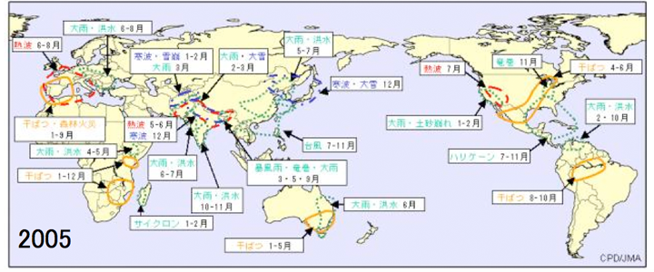
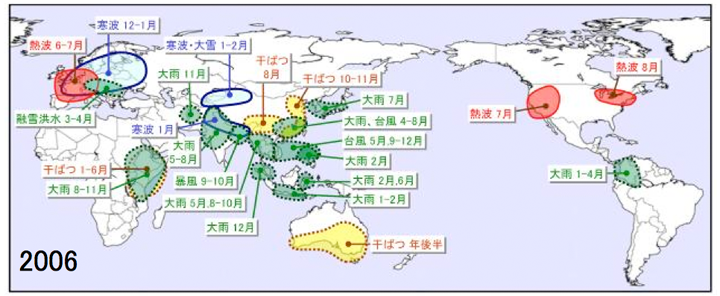
In recent years, flood damage caused by large typhoons and torrential rains has been frequent. On the other hand, damage caused by abnormally low rainfall and heat waves has also been reported in many parts of the world. The Fourth Assessment Report (AR4) of the IPCC points out that these weather disasters are causally related to global warming caused by the increase in anthropogenic greenhouse gas concentrations in recent years. Greenhouse gas concentrations are expected to continue to increase in the future. It is necessary to accurately predict the future in order to determine trends in the occurrence of meteorological disasters and to consider adaptation measures.
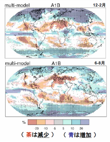
Examples of Hydrological Cycle Changes Associated with Global Warming
Examples of Hydrological Cycle Changes Associated with Global Warming: Precipitation
Necessity of Satellite Observation
Necessity of Satellite Observation
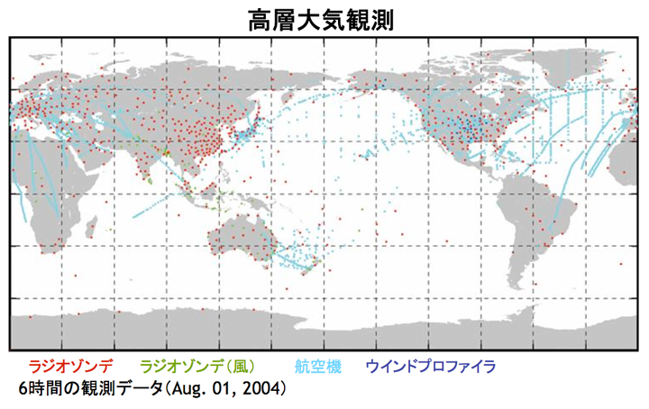
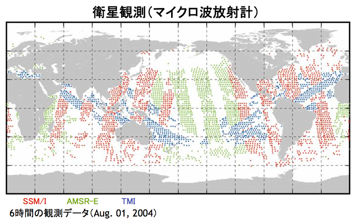
For example, meteorological elements such as temperature, pressure, wind speed and direction, humidity, and precipitation are indispensable for understanding current and future weather, climate change, and water cycles. Even if we try to observe these elements using only instruments that can directly measure them, such as ground-based meteorological instruments, radiosondes, and offshore buoys and ships, we cannot obtain information on their global distribution due to the infrequency of observations and limited observation area. In particular, data acquisition is almost impossible over the open ocean and in sparsely populated inland and polar regions where weather observation is scarce. Remote observation by satellite is the best way to obtain global meteorological and hydrological data with high frequency and high temporal resolution, including such areas where meteorological observation is not available.
What the GCOM-W mission aims to achieve
What the GCOM-W mission aims to achieve
What the GCOM-W mission aims to achieve
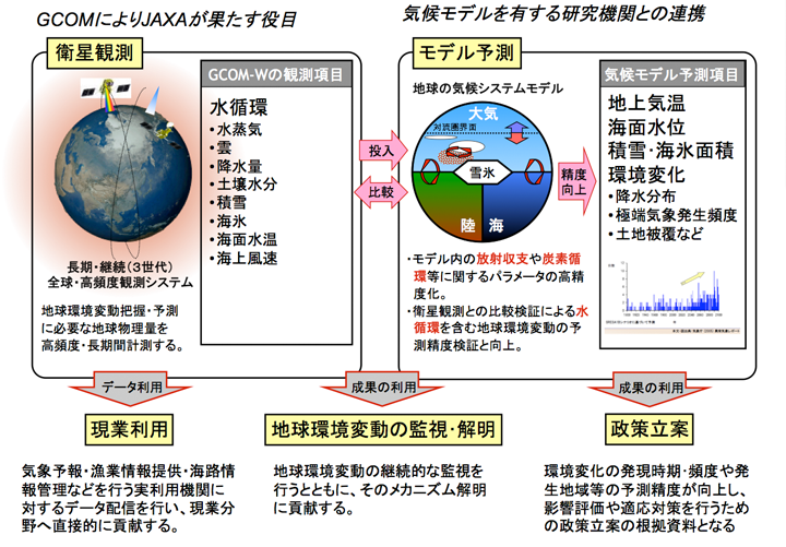
We monitor and elucidate the water cycle in the Earth's surface layer, which is the driving force of global system change, through long-term and continuous quantitative observations, and contribute to the precise prediction of water cycle changes associated with global warming by assimilating the data into numerical models of weather and climate (global models, land surface models, cloud-resolving models, etc.) and verifying these models.
Water cycle observation by GCOM-W
Water cycle observation by GCOM-W