AMSR-related Satellite Catalog:
ADEOS-II (AMSR mounted)
Get to know AMSR and satellites -- Advanced Microwave Scanning Radiometer AMSR series
  • Global Observing Satellite for Greenhouse Gases and Water Cycle
    GOSAT-GW (AMSR3 mounted)
    [Under Development]
  • Global Change Observation Mission - Water "SHIZUKU"
    GCOM-W (AMSR2 mounted)
    [In Operation]
  • NASA Aqua Satellite
    Aqua (AMSR-E mounted)
    [AMSR-E Operation Completed]
  • Advanced Earth Observation Satellite-II "Midori II"
    ADEOS-II (AMSR mounted)
    [Operation Completed]
  • Marine Observation Satellite MOS-1 / MOS1b
    MOS-1 / MOS-1b (MSR mounted)
    [Operation Completed]
  • AMSR-related Satellite Catalog
  • ADEOS-II
  • Overview

Advanced Earth Observation Satellite-II "Midori II"
ADEOS-II (AMSR mounted)

Overview

Midori II

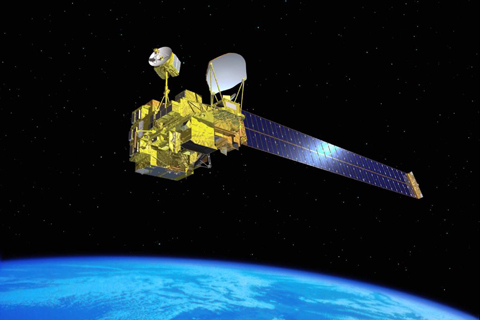
The Advanced Earth Observing Satellite-II "Midori II"(ADEOS-II), the successor of the Advanced Earth Observing Satellite "Midori"(ADEOS) launched in 1996, is also known as Midori II.

Midori II was launched by the H-IIA launch vehicle on December 14, 2002.

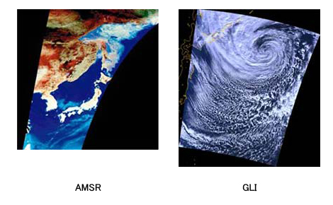
Midori II has been engaged in various observation missions to understand the realities and causes of global environmental changes, such as abnormal weather conditions and the expansion of the ozone hole. The combination of various sensor technologies allow the satellite to detect different electromagnetic waves reflected or emitted from plants, water and the atmosphere, enabling more precise observation of the Earth. Midori II is equipped with two sensors: the Advanced Microwave Scanning Radiometer (AMSR), which, day and night, can observe geographical parameters related to water; and the Global Imager (GLI), which can extensively and accurately observe oceans, land and clouds. The Global Imager is said to have attained the world's highest standards in this field, in that it can observe the reflected solar radiation from the Earth's surface, in order to understand the distribution of sea-surface temperature, snow, ice, cloud cover, aerosol, forest, sea phytoplankton, etc. Other devices on Midori II include the Improved Limb Atmospheric Spectrometer-II (ILAS-II), Sea Winds, the Polarization and Directionality of the Earth's Reflectance (POLDER), and the Data Collection System (DCS).

Observation operation results

Midori II
After an anomaly was detected in the "Midori-II" satellite on October 25, 2003, JAXA found that the possibility of restoring operations of the Midori-II was extremely slim as a result of its investigation, analysis, and inability to re-establish any communication with the satellite as of Oct. 31, 2003.
  • AMSR-related Satellite Catalog
  • ADEOS-II
  • Satellite Specification

Advanced Earth Observation Satellite-II "Midori II"
ADEOS-II (AMSR mounted)

Satellite Specification

International Designation Code 2002-056A
Launch Date 10:31, December 14, 2002 (JST)
Launch Vehicle H-IIA Launch Vehicle No.4
Location Tanegashima Space Center
Shape Approx. 4m x 4m x 6m
A box shape with a deployable solar array paddles
Weight Approx. 3,700kg
Orbiter Sun-Synchronous Subrecurrent
Altitude Approx.803km
Inclination Approx. 99 degrees
Period Approx. 101 minutes / Recurrent Period: Approx. 4day
Attitude Control Three-axis stabilization
  • AMSR-related Satellite Catalog
  • ADEOS-II
  • AMSR Overview

Advanced Earth Observation Satellite-II "Midori II"
ADEOS-II (AMSR mounted)

AMSR Specification

AMSR Specification
Item Description
Scan and rate Conical scan at 40 rpm
Antenna Offset parabola with2.0mφ
Swath width approx. 1600 km
Dynamic range 2.7 〜 340 K
Polarization Vertical and horizontal
AMSR Channel Set
Center Freq. Band width Pol. Digitization Resolution Beam width Integration time FOV Sampling interval Incident angle
6.925 GHz 350 MHz V, H 12 bits 0.34 K 1.8° 2.5 m sec 40 x 70 km approx. 10 x 10 km 55.0°
10.65 GHz 100 MHz 10 bits 0.7 K 1.2° 27 x 46 km
18.7 GHz 200 MHz 0.7 K 0.65° 14 x 25 km
23.8 GHz 400 MHz 0.7 K 0.75° 17 x 29 km
36.5 GHz 1000 MHz 0.7 K 0.35° 8 x 14 km
50.3 GHz 200 MHz V 1.8 K 0.25° 6 x 10 km
52.8 GHz 400 MHz 1.6 K
89.0 GHz - A 3000 MHz V, H 1.2 K 0.15° 1.2 m sec 3 x 6 km 約 5 x 5 km 55.0°
89.0 GHz - B 3000 MHz 1.2 K 0.15° 3 x 6 km 54.5°
  • AMSR-related Satellite Catalog
  • ADEOS-II
  • Reference Material

Reference Material

Product information, Handbook, Format description, Satellite Operation

EORC Data Distribution ADEOS-II/AMSR

Algorithm Description

EORC Bulletin / Technical Report -- Special Issue on AMSR Retrieval Algorithms --
1.5MB