


- 1. INTRODUCTION
- 2. SUMMARY OF MISSION INSTRUMENTS
- 2.1 Panchromatic Remote-Sensing Instrument for Stereo Mapping
- 2.2 Advanced Visible and Near Infrared Radiometer type
- 2.3 Phased Array type L-band Synthetic Aperture Radar
- 3. RESEARCH GOALS AND OBJECTIVES
- 3.1 Calibration and Validation of ALOS data products and sensors
- 3.2 Utilization Research
- 3.3 Scientific Research
- 4. DATA DISTRIBUTION
- 4.1 Data Policy
- 4.2 Data Distribution before ALOS Launch
- 4.3 Data Distribution after ALOS Launch
- 5. FUNDING
- 6. QUALIFICATIONS OF APPLICANTS
- 7. BENEFITS AND RESPONSIBILITIES OF PIS
- 7.1 Benefits
- 7.2 Responsibilities
- 8. PROPOSAL SUBMISSION
- 8.1 General Conditions
- 8.2 Language
- 8.3 Length
- 8.4 Proposal Contents
- 8.5 Where to Send Proposal
- 9. SELECTION OF PROPOSALS
- 9.1 Evaluation and Selection Procedures
- 9.2 Evaluation criteria
- 9.3 Follow-on Action
- 10. CANCELLATION AND POSTPONEMENT OF RA
- 11. RESEARCH ORGANIZATIONS
- 12. SCHEDULE
- 12.1 ALOS First Research Announcement (this RA)
- 12.2 ALOS second Research Announcement (Now planning)
- 13. RESEARCH ANNOUNCEMENT OFFICE
- APPENDIX A ALOS SYSTEM DESCRIPTION
- APPENDIX A-1 ALOS CHARACTERISTICS
- APPENDIX A-2 CHARACTERISTICS OF EACH SENSOR
- 1. Panchromatic Remote-Sensing Instrument for Stereo Mapping
- 2. Advanced Visible and Near Infrared Radiometer type 2
- 3. Phased Array type L-band Synthetic Aperture Radar
- 4. Mass Data Handling
- 5. Position and Attitude Determination
- APPENDIX A-3 DATA PRODUCTS
- 1. Definition of ALOS Data Products
- 2. Standard Data Products
- APPENDIX A-4 ALOS OPERATION CONCEPT
- 1. Priority of Sensor Observation Mode
- APPENDIX B ALOS RESEARCH PLAN
- 1. Goals of ALOS Research Plan
- 2. Calibration and Validation of Each Sensor and Related Basic Studies
- 3. General Goal
- 4. Strategic Goals
- APPENDIX C ALOS SIMULATION DATASETS
- 1. Simulation Datasets for the Optical Sensor
- 2. Simulation Datasets for the SAR
- APPENDIX D PROPOSAL CONTENTS AND APPLICATION FORMS
- 1. Proposal Coversheet
- 2. Detailed Description of Proposal (Up to five pages)
- 3. Work Plan (Research Schedule)
- 4. Details of Data Requirements
- 5. Personnel 36. Data processing and analysis equipment
- Form 1 Proposal Cover Sheet
- Form 2 Work Plan (Research Schedule)
- Form 3a Details of Data Requirements
- Form 3b Observation Requests for ALOS
This National Space Development Agency of Japan (NASDA) Research Announcement (RA) is soliciting research proposals for science and utilization research. This research will support the Advanced Land Observing Satellite (ALOS) Research Plan to be carried out by members of a newly formed ALOS research team exploiting PRISM, AVNIR-2 and PALSAR sensor data. Membership in this team will be conferred on successful respondents to this RA. Proposals are solicited for conducting research in the following three categories:
- Calibration and Validation of ALOS data products and sensors
- Utilization research
- Scientific research
ALOS follows the Japanese Earth Resources Satellite-1 (JERS-1) and the Advanced Earth Observing Satellite (ADEOS) and will utilize advanced land observation technology. ALOS will be used for cartography, regional observation, disaster observation, and resources surveying.
ALOS mission objectives are to:
(1) develop digital elevation models (DEMs) and related geographic data products for Japan and other countries including those in the Asian-Pacific region (Map Making),
(2) perform regional observation for "sustainable development" (harmonization between Earth environment and development) (Regional Observation),
(3) conduct disaster monitoring around the world (Disaster Monitoring),
(4) survey natural resources (Resources Survey), and
(5) develop sensor and satellite technology for future Earth-observing satellites (Technology Development).
The ALOS launch is scheduled for August-September 2002, on an H-IIA launcher. The planned operational lifetime is five year. Data, excluding data for calibration and validation, will be released starting not earlier than eight months after launch.
The PIs can cover the full range of ALOS science and applications, including (1) land use and land cover research, (2) topography and geology, (3) terrestrial (vegetation) ecosystem, agriculture and forestry research, (4) climate system, hydrological processes and water resources related research, (5) oceanography and coastal zone related research, (6) disaster and earthquakes, (7) resource exploration, (8) development of spatial data infrastructure, (9) basic studies on scattering and interferometric characteristics, and (10) basic studies for accurate observation with high-resolution optical sensors.
Applicants may submit any time before January 31, 2000. Proposals will be peer reviewed by the end of April 2000. Applicants submitting accepted, applicants will be integrated into the ALOS research team.
Participation as an ALOS Principal Investigator is open to researchers from all categories of organizations: educational institutions, research institutes, private enterprises and government institutions and any other organizations.
Funds for PIs are not available under this RA.
The advantages of a PI are:
- access to relevant ALOS data at no cost and
- data acquisition priority in the mission operation plan.
APPENDIX A provides technical and programmatic information concerning the ALOS system, data products, characteristics of each sensor, and general operation concept.
APPENDIX B provides objectives of the research activities covered by this RA.
APPENDIX C defines ALOS simulation datasets.
APPENDIX D contains the basic guidance needed for preparing proposals in response to this RA.
Future opportunities, but of a more restricted nature, for submitting proposals for the exploitation of ALOS data are envisaged after the launch of the satellite and its successful commissioning, starting about one year after launch.
ALOS has three remote sensing instruments: the Panchromatic Remote-Sensing Instrument for Stereo Mapping (PRISM) for generating of Digital Elevation Models (DEMs), the Advanced Visible and Near Infrared Radiometer type 2 (AVNIR-2) for multispectral land coverage observation, and the Phased Array type L-band Synthetic Aperture Radar (PALSAR) for 24-hours all weather land observation. These sensors are expected to contribute to high-resolution land observation. (A detailed description of each payload is given in APPENDIX A-2.)
2.1 Panchromatic Remote-Sensing Instrument for Stereo Mapping
The Panchromatic Remote-Sensing Instrument for Stereo Mapping (PRISM) is a panchromatic radiometer with 2.5-meter spatial resolution. It has three telescopes for forward, nadir and backward views enabling us to generate DEMs with accuracy sufficient for 1/25,000 scale maps.
2.2 Advanced Visible and Near Infrared Radiometer type 2
The Advanced Visible and Near Infrared Radiometer type 2 (AVNIR-2) mainly observes land and coastal zones and can provide land cover and land use information maps for monitoring regional environments. The instrument also has a cross-track pointing function for disaster monitoring.
2.3 Phased Array type L-band Synthetic Aperture Radar
The Phased Array type L-band Synthetic Aperture Radar (PALSAR) is an active microwave sensor which enables all-weather, 24hours land observation. It has improved performance over the Synthetic Aperture Radar (SAR) on the Japanese Earth Resources Satellite-1 (JERS-1). The sensor has a steerable beam in elevation and the ScanSAR mode, which allows us to obtain a wider swath than conventional SARs. PALSAR was jointly developed by NASDA and the Japan Resources Observation System Organization (JAROS).
The various products derived from ALOS data are expected to contribute significantly to the advancement of science. The research results in this RA will be utilized effectively for various applications such as Earth environment monitoring, natural resource exploration, disaster monitoring, and regional development planning. This RA specifically solicits research that uses ALOS data alone or in conjunction with other datasets in three categories, (1) Calibration and Validation, (2) Utilization Research, and (3) Scientific Research.
3.1 Calibration and Validation of ALOS data products and sensors
The three imaging sensors onboard ALOS are designed for superior performance in various aspects of high-resolution Earth observation.
These sensors must be calibrated and validated for us to achieve
- realistic performance in measuring an image's radiance (radar back scattering) and locations and
- the potential of retrieving geophysical parameters (digital elevation model, geo-location, forest distribution, ice-monitoring, intereferometry, disaster monitoring, etc.) for Earth environmental monitoring
In this RA, we have set two research goals related to the above. We would like to solicit your research proposals for achieving these goals.
(1) Calibrate Individual Sensors
This category seeks to clarify the sensor's input and output relationship (including determining calibration coefficients) as well as the sensor characterization with or without ground truth data. The target sensors are PRISM, AVNIR-2, and PALSAR.
More detailed research items are given below.
PRISM
- Sensor performance evaluation (including image quality evaluation)
- Geometric calibration
- Radiometric calibration (including stripe removal and determining calibration coefficients)
AVNIR-2
- Sensor performance evaluation (including image quality evaluation)
- Geometric calibration
- Radiometric calibration (including stripe removal and determining calibration coefficients)
PALSAR
- Sensor performance evaluation (including image quality evaluation)
- Geometric calibration
- Radiometric calibration (including antenna pattern determination and polarimetry)
(2) Develop and Validate Algorithms for Extracting Physical Parameters
It is important to develop algorithms that extract geophysical parameters from the calibrated images and truth data. It is also important to validate the estimated geophysical parameters using the above algorithms.
The many geophysical parameters that might be derived from ALOS data are listed in APPENDIX B. Since NASDA defined 1) digital elevation model and 2) orthophoto images as the geographical products to be produced, NASDA has temporarily established these two as high-priority solicited algorithms.
However, proposals on developing and validating the other geophysical parameters are also welcome.
3.2 Utilization Research
The objectives earlier Japanese Earth Observation Satellite emphasized the scientific element. Except for a limited category of data that is already being used operationally, the satellite data has not been used operationally owing to many technical and operational issues. However, in the preparatory operational phase of Earth observation data, utilization technology must be urgently established, and operational use in social systems is expected. A significant effort will thus be made to enhance opportunities fully employing data processing technology cultivated by JERS-1 and ADEOS as well as for promoting new developments.
The integration of ALOS data with numerical prediction models of sea ice, sea state, and disasters as well as monitoring and managing agricultural products, and forestry, and fishery will directly lead to national benefits. Providing the ALOS for international utilization will also lead to the discovery of potential users and the enhancement of the market. Moreover, a wide range of provided data and user-oriented or value-added services will be able to satisfy a variety of market needs from personal to commercial applications.
Examples of utilization research are given below.
- Land use and land cover change monitoring
- Forecasting of sea-state conditions and seas ice for off-shore applications
- Ship traffic monitoring and fishery management in coastal waters
- Agriculture and forestry management
(planting status, agricultural productivity estimation, vegetation changes, etc.) - Natural disasters (forest fires, flooding, landslide, earthquakes, etc.)
- Pollution monitoring (oil spill, red tide, etc.)
- Geology and natural resources exploration
- Applications related to SAR interferometry
(digital elevation models, crustal movements, vegetation distribution, etc.), - Development of the Geographic Information System (GIS) database at national land
- Educational use
Some utilization research will require providing of data products satisfying user requirements in near real-time. In this case, applicants must specify their requirements and clarify the propriety.
Proposals should indicate research and development activities requiring operational use of ALOS data products, whether derived from ALOS data alone or from ALOS data integrated with that of other satellites. Such proposals should also include the definition of new products and algorithms required for the application development.
In addition, applicants should define objectives, methods, and implementation plans of the projects as precisely as possible, and their plan should indicate the means, the feasibility of realization, and the anticipated economic effects gained by achieving the objectives.
See APPENDIX B for details on utilization research.
3.3 Scientific Research
The data products obtained by ALOS will contribute to promoting science. It will be essential to address many environmental issues (such as vegetation change, biomass burning, water resource management, resource assessment, disaster and earthquake mitigation, and cryosphere monitoring) in a broad range of Earth science disciplines. Our current knowledge of the complex interactions between the various components of the Earth system is not yet sufficient to predict environmental changes with the accuracy required for effective strategic development.
Proposals in response to this RA may address one or several Earth Science domains including both basic scientific research (e.g. land surface properties, measurement principles, and algorithm development for derivation of geophysical parameters) and studies of Earth Science processes. The targets have various time and spatial scales from local to regional and global. It may be possible to compare these analyses with analyses for other satellites data (such as from JERS-1 or ADEOS). Examples of major objectives are presented below.
- Land use and land cover change
- Topography and geology
- Terrestrial ecosystem, agriculture and forestry
- Climate system, hydrological processes, and water resource related research
- Oceanography and coastal zone related research
- Process studies for microwave scattering and SAR interferometry
- Basic studies for measuring accuracy by optical sensors with fine spatial resolution
More detailed information is given in APPENDIX B. In addition, proposals should include the definition of objectives, scope and approach as well as an implementation plan for the research. The implementation plan should also indicate time horizons and means necessary for the achievement of prospected results.
4.1 Data Policy
For this RA, the data will be provided free of charge to PIs who agree to the following.
- 1) NASDA (NASDA and MITI for PALSAR data) possesses all intellectual property rights of the provided data and products.
- 2) Provided data shall be utilized only for the peaceful purposes.
- 3) Provided data shall be utilized only for conducting RA activities.
- 4) Provided data shall not be transferred to an unauthorized third party or person.
Other detailed conditions, such as the number of the data scenes, shall be determined through review by NASDA.
Applicants must realize that data for PIs will be limited by satellite operations, the position of the Data Relay and Tracking Satellites (DRTS) and so on. Refer to APPENDIX A-2 for the non-observable areas of each sensor.
NASDA shall not be liable for data loss, deterioration in data quality, or delay of data supply resulting from problems of ALOS or ground facilities, or for not providing ALOS data due to bad weather or matters beyond NASDA's control.
4.2 Data Distribution before ALOS Launch
(1) Satellite data belonging to NASDA
To the extent available, the PIs selected in this RA can receive the following satellite data belonging to NASDA upon request. The resources depend on NASDA's product equipment and the balance with other project requests.
- Satellite data include sensor data of MOS, JERS-1, ADEOS, TRMM, ADEOS-II (nominal launch date November 2000), ERS*, SPOT*, RADARSAT*, LANDSAT* and IRS*.
* Foreign satellite data are limited to that received at ground stations in Japan, and the amount of available data depends on NASDA's resources. For details on restrictions, see section 4.2 in APPENDIX D.
(2) ALOS Simulation Datasets
To the extent available, the PIs selected in this RA can receive simulation data for PALSAR and PRISM upon request. These datasets are generated using aerial images covering specific areas in Japan. The covered areas and the geographical features of the data for PIs are listed in APPENDIX C.
4.3 Data Distribution after ALOS Launch
NASDA recommends that PIs utilize the data produced in the ALOS standard operation plan which is decided based on the ALOS Operation Concept (APPENDIX A-4). Nevertheless, NASDA will accept observation requests from the selected PIs within resource limitations in this RA.
(1) Standard Data Products
The PIs will be provided the following data eight months after ALOS launch. Data for Calibration and Validation will be distributed as soon as possible three months after the launch. Further detailed information is presented in Table 5 of APPENDIX A-3.
- PRISM Level 1A, Level 1B1 and Level 1B2
- AVNIR-2 Level 1A, Level 1B1 and Level 1B2
- PALSAR Level 1.0, Level 1.1 and Level 1.5
(2) Higher-Level Data Products of EORC
Beginning one year after ALOS launch, the PI's will be provided higher-level data products of NASDA's selected area as sample datasets. They will also be provided products of some areas they have requested.
- PRISM DEM, Orthophoto Image
- AVNIR-2 Orthophoto Image
- PALSAR DEM, Orthophoto Image
(3) Satellite data belonging to NASDA
Satellite data here means sensor data from MOS, JERS, ADEOS, TRMM, ADEOS-II, ERS*, SPOT*, RADARSAT*, LANDSAT* and IRS*.
* Foreign satellite data are limited to that received at ground stations in Japan, and the amount of available data depends on NASDA's resources. For details on restrictions, see section 4.2 in APPENDIX D.
NASDA will not provide funds to PIs.
We welcome all researchers from educational institutions, research institutes, private enterprises, government institutions, and any other organizations, domestic or foreign, to submit research proposals for peaceful purpose.
7.1 Benefits
PIs can request satellite data and simulation datasets listed in section 4 at no cost. Moreover, after the launch, PIs can submit observation requests (see APPENDIX D 4.2), subject to some limitations.
7.2 Responsibilities
7.2.1 Interim Report
The PIs will be required to submit interim reports on the status of their researches in the format given by NASDA. They are encouraged to participate in PI meetings held by NASDA and present the progress and accomplishments of their researches. In particular, PIs must submit an interim report to NASDA during FY2002 (from April 2002 to March 2003) for interim evaluation performed by March 2003.
7.2.2 Final Report
All PIs must submit their final reports to NASDA in English in accordance with instructions in the agreement. They must present their results or part of their results at a meeting, symposium or workshop conducted by NASDA.
8.1 General Conditions
Because a number of proposals are expected to be submitted from all over the world, we might not accept proposals which do not adhere strictly to the format. The following are required in all proposals.
- Applicants must register their profiles from the ALOS Home Page (http://www.eorc.jaxa.jp/ALOS/RA) by January 31, 2000.
- The proposal must be submitted in hard copy form using a format defined by NASDA or provided on the ALOS Home Page. (Please refer to this section and APPENDIX D.)
- Applicants must send six copies of the proposal including a complete set of attachments, such as reprints of papers, to NASDA.
- All proposals should be submitted on plain white paper the size of letter or A4, and type-written in either English or Japanese, with a font size smaller than 12 points.
- Each page must have a page number in the middle of the bottom and the name of the applicant in the upper right corner.
Proposals are not returned.
8.2 Language
Applicants must basically submit their proposals to NASDA in either English or Japanese. However, applicants in Japan are required to submit the "information of applicants" in the proposal cover sheet (APPENDIX D form 1a) in both English and Japanese.
8.3 Length
Unless otherwise specified in this RA, proposals should be as brief as possible, concentrating on substantive material. Proposals should not exceed 20 pages.
For further details, see APPENDIX D.
8.4 Proposal Contents
Please refer to APPENDIX D.
8.5 Where to Send Proposal
Please send all the necessary application papers for the First RA by post mail to the following address by January 31, 2000.
ALOS Research Announcement Office (Yoshihide Katoh, Project Coordinator)
Earth Observation Research Center
National Space Development Agency of Japan
Roppongi First Building 14F
1-9-9, Roppongi, Minato-ku, Tokyo 106-0032 Japan
Tel: +81-3-3224-7074 Fax: +81-3-3224-7051
Email: aproject@jaxa.jp
9.1 Evaluation and Selection Procedures
Proposals will be reviewed and evaluated by experts on the Research Evaluation Committee assigned by NASDA based on the evaluation criteria shown in 9.2. Final decisions on acceptance of proposals will be made by NASDA (the ALOS Research Board), taking into account the overall balance of different proposals and their resource requirements as well as the evaluation result. PIs will be notified of proposal acceptance by the end of April 2000.
9.2 Evaluation criteria
1) Overall social, scientific, or technical merit of the proposal or unique and innovative methods, approaches, or concepts demonstrated by the proposal.
2) Applicant's capabilities, related experience, facilities, techniques, or unique combinations of these which are integral factors for achieving the proposal objectives.
3) Relevance to the objectives of the ALOS Research Plan.
4) Technical possibility within the research period.
9.3 Follow-on Action
After applicants are notified of selection as a PI, they are required to observe the terms and conditions of the projects including, but not limited to, data distribution and publications of results. NASDA will send an agreement form to the selected PIs later; PIs should follow the procedures therein.
NASDA reserves the right to cancel this RA upon notice delivered by NASDA. NASDA assumes no liability for canceling the RA, for postponing the RA schedule, or for anyone's failure to receive actual notice of cancellation.
A tentative concept of ALOS research organizations is shown in Fig. 1.
An ALOS Research Board chaired by an ALOS program scientist will be established. The ALOS Research Group, composed of Sensor Teams, and the Research Promotion Group will be organized under the NASDA ALOS Research Board. In addition, subteams for Algorithm Development, Calibration and Validation, Datasets Production, and Science and Utilization Research will be organized under the appropriate teams.
The role of the ALOS Research Board established in EORC is to provide advice and make final decisions for selecting proposals, and to provide recommendations for each subteam. The Research Evaluation Committee evaluates research activities based on predetermined criteria, and will be organized outside NASDA to ensure fair evaluation of proposals. The Calibration and Validation subteam will cooperate with the ALOS Project Team, Earth Observation Systems Engineering Department (EOSD), and Calibration and Validation PIs who will be selected by this Research Announcement (RA).
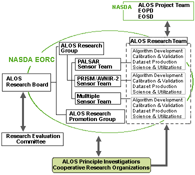
Fig. 1 Tentative concept of ALOS research organizations.
NASDA plans to release two ALOS RAs. The schedule of this RA is shown in 12.1.
12.1 ALOS First Research Announcement (this RA)
- Document release October 1999
- Deadline for submission of proposals January 31, 2000
- Notification of PI selection April 30, 2000
- Contract May 2000 <-->July 2000
- PI meeting and Symposia August 2000 a
- Interim evaluation March 2003 (in FY2002)*
* In principal, the research duration is three years. However, NASDA may grant a two-year extension based on the interim evaluation results.
12.2 ALOS second Research Announcement (Now planning)
NASDA intends to solicit proposals for further fields, focusing on Utilization Research and Scientific Research using ALOS data in the second RA. It will be released after the fall of 2002.
ALOS Research Announcement Office
Earth Observation Research Center
National Space Development Agency of Japan
Roppongi First Building 14F
1-9-9, Roppongi, Minato-ku, Tokyo 106-0032
Japan
Tel: +81-3-3224-7074
Fax: +81-3-3224-7051
E-mail: aproject@jaxa.jp