2017
January 17, 2017 (JST)
Japan Aerospace Exploration Agency
Global Precipitation Measurement (GPM) Global Satellite Mapping of Precipitation (GSMaP) Products (Version 04) Release
JAXA has started to provide a new version (Version 04) of Global Precipitation Measurement (GPM) Global Satellite Mapping of Precipitation (GSMaP) product. The GPM Version 04 data are available from January 17, 2017.
Concurrently, existing GPM/GSMaP data are also being reprocessed back to the start of the mission.
GPM/GSMaP Version 04 products are available from G-Portal and JAXA Global Rainfall Watch. Figure 1 shows a comparison between GSMaP_GMI Version 03 and Version 04 on January 2015. In the Version 03, detections of snowfall were lacked and missing values (grey color) were found in the Eurasian Continent and North American Continent. On the other hand, the detections of snowfall were found over the high latitudes in the Version 04.
Major algorithm changes from Version 03 to Version 04 (algorithm version v6 to v7) were described in the "GPM/GSMaP Product V04 (Algorithm version 7) Release Note![]() " of the EORC Web site.
" of the EORC Web site.
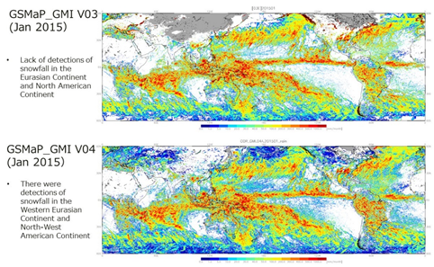
Figure 1: Comparison of surface precipitation rate between GSMaP GMI V03 and GSMaP GMI V04 on January 2015.


