ページの先頭です。
本文へジャンプする。
【Important Notices】This page is an archive page of information published in the past. Since the update has been completed, it may contain broken links or outdated information. For the latest information, please use the new site Earth-graphy (earth.jaxa.jp).
ここからサイト内共通メニューです。
サイト内共通メニューを読み飛ばす。
サイト内共通メニューここまで。
ここから本文です。

Seen from Space 2009

Historic Village Shirakawa-go


Fig. 1. Shirakawa-go and vicinity

Figure 1 presents an image of Shirakawa-go in Gifu Prefecture and its vicinity as observed in September 2007. The blue area in the top-left of the image is the Japanese Sea. The grey urban area below the blue area (sea) depicts Kanazawa, Hakusan and Komatsu cities in Ishikawa Prefecture. Komatsu International Airport, where large 747 aircraft land, is also visible. The other visible grey urban areas are Ohno City in Fukui Prefecture (called Little Kyoto in Hokuriku), Katsuyama City, and Nanto City in Toyama Prefecture.
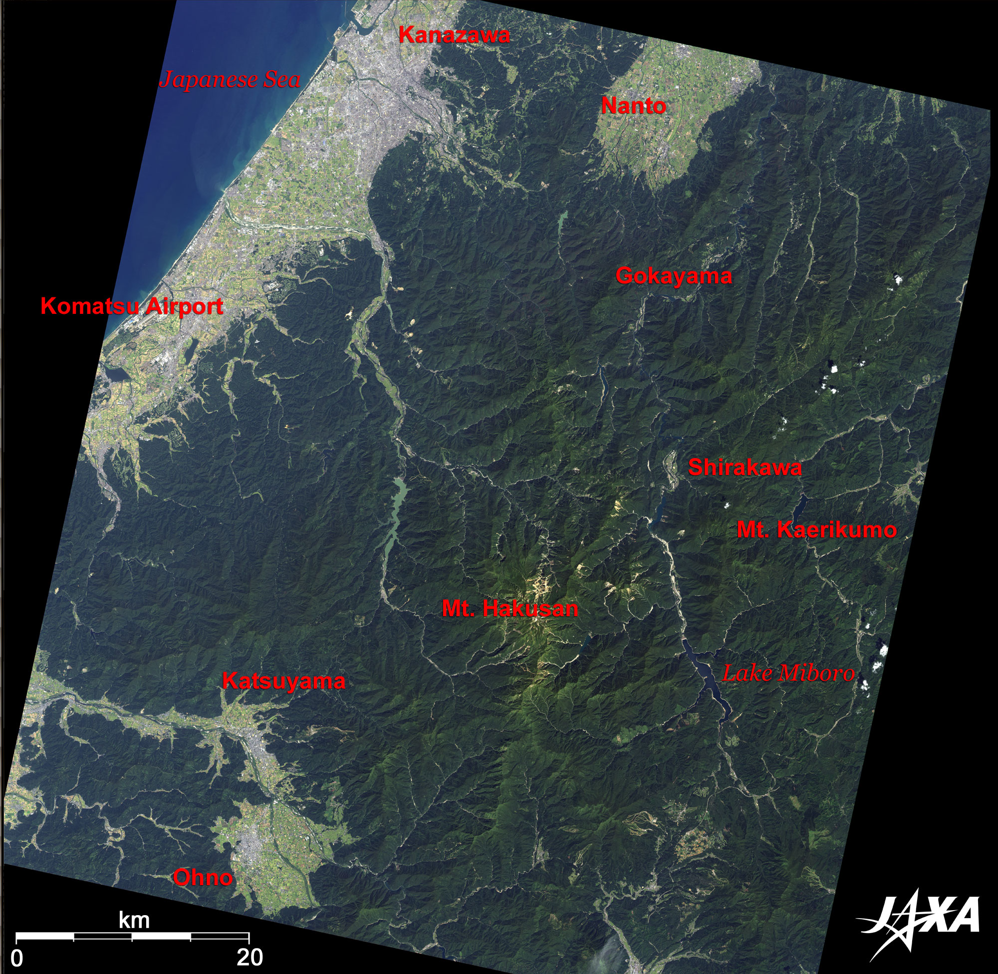
Mt. Haku-san (meaning "white mountain"; highest peak (Gozenmine) 2,702 m above sea level) in the center of the image is one of the three major mountains in Japan (the others being Mt. Fuji and Mt. Tate-yama). Hakusan National Park extends 20 km east and west, and 40 km north and south, encompassing parts of Toyama, Ishikawa, Fukui and Gifu Prefectures and most mountains in the central figure.

Sho River meanders from south to north on the right of Mt. Haku-san. Shirakawa Village lies on the riverbank; it is called Shirakawa-go and is traditional scene in Japan. Traditional Gassho-style colonies in a harsh natural environment still depict old Japan. Small Gassho-style colonies, Gokayama (Nanto City in Toyama Prefecture) including Ainokura and Suganuma districts are also visible at the right-angle bend of the river and 15 km north of Shirakawa-go. Historic Villages Shirakawa-go and Gokayama were added to the list of World Cultural Heritage sites of the United Nations Educational, Scientific, and Cultural Organization (UNESCO) in September 1995 as outstanding examples of traditional scenery and the environmental circumstances.

On 2 December 2008, the Japan Aerospace Exploration Agency (JAXA) and the United Nations Educational, Scientific, and Cultural Organization (UNESCO) signed a cooperation agreement in monitoring World Heritage Sites using the Advanced Land-Observing Satellite "DAICHI" (ALOS) to watch and protect the common legacy of all mankind.

Lake Miboro, 15km south of Shirakawa-go, is a man-made lake on the upper stream of Sho River with Miboro Dam (completed in 1961). The rock-fill dam is a 131 m-high, 405 m-long trapezoid filled with clay and sand. The over 450-year old Shogawa Cherry tree transplanted during construction of the dam is very famous.
Mt. Kaerikumo, which collapsed in the great Tensho Earthquake of 1586, is known to be the home of the warrior Uchigashima family. Uchigashima was a mine engineer and mined gold near here. It may be why people lived deep in the snow-covered mountains. Kaerikumo castle and its associated business area were ruined with the Uchigashima family in one day by a great landslide during the earthquake. The 80 km-long Miboro active fault line still runs along Sho River.

Fig. 2. Shirakawa-go
Shirakawa-go (kmz, 5.35 MB, Low Resolution) as seen on Google Earth.
Shirakawa-go is a great community of colonies (Shirakawa-go and Gokayama (Ainokura and Sugayama)) recognized by the World Cultural Heritage and has over 110 Gassho-style houses. The Tokai-Hokuriku expressway interchange is near Shirakawa-go and is convenient for sightseeing.
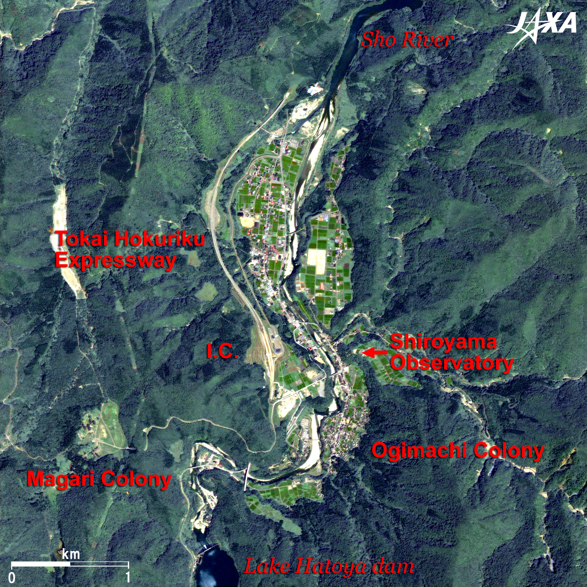
Gassho-style houses are traditional buildings built from the middle of the Edo era (1600 to 1868) to the beginning of the Showa era (1926 to 1989). Many houses disappeared after 1960, but a “No sell, No rent and No destroy” preservation movement has been started.
The road to the left of Shirakawa-go is the Tokai-Hokuriku expressway. An interchange of the expressway is visible. Sho River flows through Shirakawa-go.

Shiroyama observation platform (Ogimachi in Shirakawa village) on the east of Shirakawa-go has a fine view of a Gassho-style village. Shiroyama is one of the forts of the Uchigashima family. Many purple Gassho-style houses dot the south of Shiroyama observation platform and on either side of Sho River.
Ogimachi district has Wada, Kanda and Nagase housees, as well as other famous Gassho-style houses and museums of important cultural assets. Other Gassho-style houses are also visible in Magari district.

Figure 2 presents a summer view, but snow-capped winter is the best season for visiting Shirakawa-go.


Explanation of the Images:

(Click the images twice to enlarge.)
Satellite: Advanced Land-Observing Satellite (ALOS) (Daichi)
Sensor: Advanced Visible and Near-Infrared Radiometer-2 (AVNIR-2) and
Panchromatic Remote-Sensing Instrument for Stereo Mapping (PRISM)
Date: 0146 (UTC) on July 27, 2007 (PRISM) (Fig. 2)
0146 (UTC) on September 11, 2008 (AVNIR-2) (Figs. 1 and 2)
Ground resolution: PRISM, 2.5m; AVNIR-2, 10m
Map Projection: Universal Transversal Mercator (UTM)
AVNIR-2 has four observation bands. Figure 1 is produced by assigning red to Band 3 (610 to 690nm), green to Band 2 (520 to 600nm), and blue to Band 1 (420 to 500nm). The resulting images have natural coloring as if seen by the naked eye. Thus, the following colors designate ground objects.

Dark green: Forests
Light green: Grass or farmland
Grey: City area or roads
Blue: Water area (sea and rivers)

PRISM is an optical sensor for observing ground surfaces with visible and near-infrared signals in the 520 to 770 nanometer (one-billionth of a meter) band. The acquired image is monochrome. PRISM has three independent optical systems (telescopes) to acquire images for nadir, forward, and backward views at the same time so that terrain data, including altitude data, can be obtained. Only the backward images were used in this article.
The AVNIR-2 composite image was transformed into hue, saturation and intensity, and the intensity was replaced by the PRISM image. The hue, saturation and intensity data were then reversed into a color image. The result was a virtual 2.5m-ground-resolution color image. This kind of high-resolution color image (Fig. 2), composed by combining the higher-resolution monochrome image and the lower-resolution color image, is called a pan-sharpened image.
Thus, colors represent the same features as in the above-mentioned AVNIR-2 image.

Related Sites:
ALOS Research and Application Page
Kanazawa: The Castle Town of the Old Kaga Domain that Occupied One Million Goku Feudality
Historic Villages of Shirakawa-go and Gokayama (Japan)
Land, Seen from Space
本文ここまで。
image:Satellite Navigator
image:Satellite Applications and Operations Center(SAOC)
Earth Data Collection by JAXA Satellites
image:ページTOP