| |
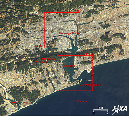 |
Fig. 1. Kochi City and Vicinity
Kochi City (kmz, 4.65 MB, Low Resolution) as seen on Google Earth. |
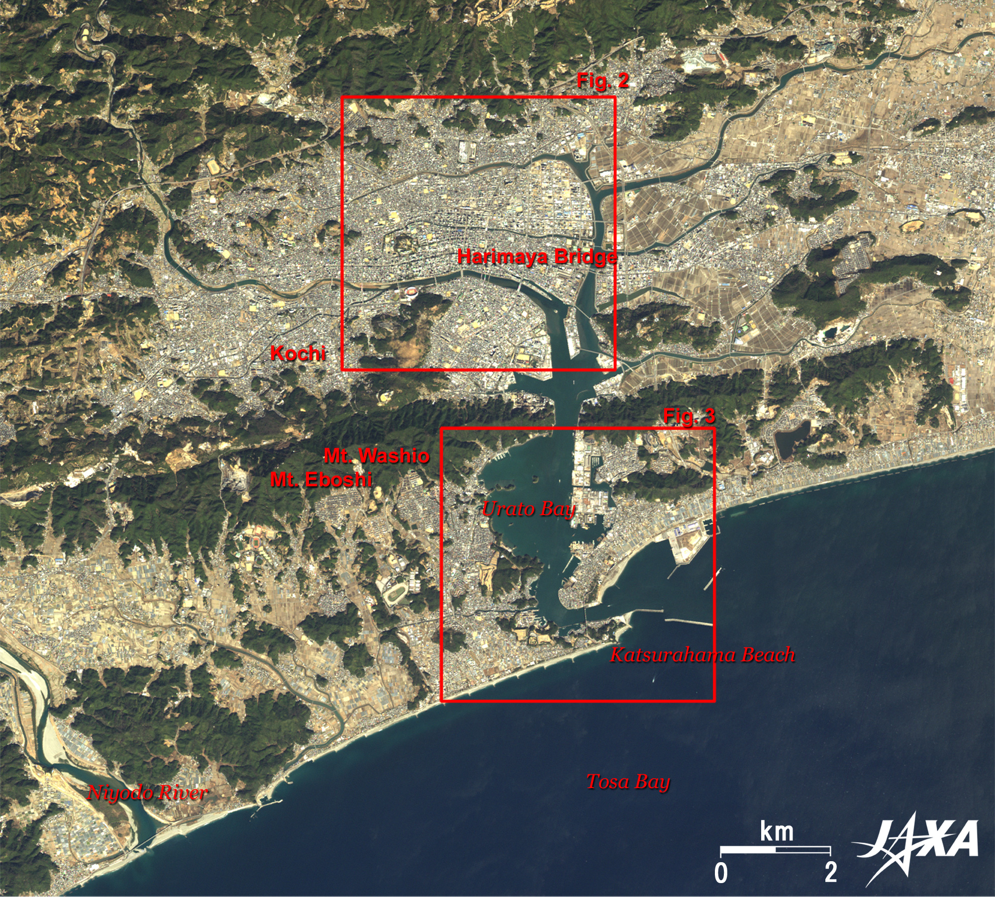
Figure 1 depicts Kochi City (population 300,000) in Kochi Prefecture. Harimaya-bashi Crossroads, Kochi Castle and Kochi Prefectural Government are in central Kochi City on the north side of Urato Bay, and Mt. Washio (300m above sea level) and Mt. Eboshi (359m). Katsurahama and Tosa Bay are visible on the south of the hill. On the left side of the image is Niyodo River (124km long), one of three longest rivers in Shikoku along with Yoshino River and Shimanto River. This river appeared in scenes in the novels by Tomiko Miyao from Kochi City. Shikoku Mountain Range lies diagonally across Shikoku from west to east and has over one-thousand-meter steep mountains. Kochi Expressway with 22 up and 19 down tunnels (including a 50km section between Kawanoe Junction and Nankoku Interchange) runs through Kochi Prefecture and the Kochi Mountain Range.
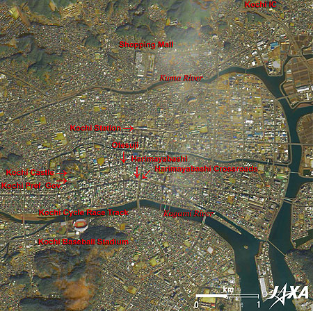 |
| Fig. 2. Harimaya Bridge |
Figure 2 depicts the Harimaya Bridge in Central Kochi City. The Harimaya Bridge is featured in folk songs of Kochi Prefecture, a verse of Yosakoi Bushi (song). The Harimaya Bridge is the name of a crossroads and the station name of tram car in Kochi City, but the existing Harimaya Bridge is a pretty bridge on the northwestern corner of the Harimaya Bridge Crossroads.
The bridge was originally a small private bridge over Hori River between wealthy merchants Harimaya and Hitsuya in the Edo Era. The Hori River was reclaimed after War II, but was reborn in 1988, and the Edo-style 20m-long Harimaya Bridge with its lacquered parapet was restored. At the foot of the small bridge stand pretty stone statues of monk Junshin and the pretty girl Ouma, characters in a tragic love story . There is also a Meiji-Era-style cast iron Harimaya Bridge near there.
Yosakoi Festival originated from the Yosakoi Song in 1954 as a measure to boost the post-war economy and spread throughout Japan. The Yosakoi Dance in the Festival started with a Bon Festival dance style but took the rhythm of rock and samba, and became known to Europeans as the Japanese Samba.
Elevated Kochi station was redecorated in February 2008 and is visible 1km north of Harimaya Bridge Crossroads. It has a large dome made from the plentiful local Japanese cedars. Its big roof (60m east and west, 38m north and south, and 23m in height) covers the station. This station was the first of its style in Japan and is called Whale Dome. The roof, a titanium-zinc alloy, is visible from space. The large building 900m north from Kochi Station is a shopping mall that opened in 2000 with an area of 82,600 square meters. Kochi Expressway Interchange is located 2km from downtown Kochi City and is very convenient.
The first lord of Tosa Province in the Edo Period, Kazutoyo Yamanouchi (1545 to 1605), lived in Kochi Castle, which is located 2km west of Harimaya Bridge. The castle was named Kouchiyama ("mountain in the river") Castle when Honmaru and Ninomaru buildings were completed, and Kazutoyo entered the castle in 1603. The second lord, Tadayoshi, renamed it Kochiyama Castle after frequent floods. Kochi derived its name from the castle. The original castle was burnt down in 1727 and rebuilt in 1753. The current castle remains almost after this reconstruction. You can see Kochi Prefectural Government building near the south of the castle. Kochi Cycle Race Track and Kochi City Baseball Stadium are also visible on the south bank of the Kagami River.
The Sunday Market opens in Otesuji Street between Harimaya Bridge and Kochi Castle every Sunday and is 1,300m long. Other street markets also open in Kochi City, except on Monday and Saturday. The main dance competition site is located on Otesuji Street during the Yosakoi Festival.
 |
| Fig. 3. Katsurahama Beach |
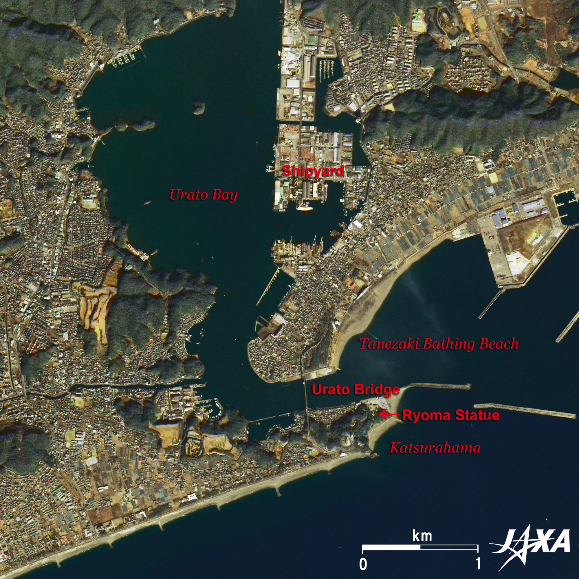
Figure 3 presents Katsurahama Beach with its arc beach. The beach is famous for Moon viewing and appeared in the Yosakoibushi. Urato Castle of Motochika Chosokabe (1539 to 1599), a Sengoku (Civil War) period warlord, is on the north hill of the beach. The area was a central part of Tosa Province before Kazutoyo Yamanouchi received the castle as a reward for his achievements in the Battle of Sekigahara in 1600. A towering bronze statue (13m height including the pedestal) of Ryoma Sakamoto (1836 to 1867), a hero in the last days of the Tokugawa Shogunate, now stands atop a hill on the Ryuzu Misaki Cape near the castle, facing the Pacific Ocean.
Joshi (upper-class samurais, servants of the Yamanouchi family) and Goshi (lower-class samurais, former servants of the Chosokabe family) were called in Tosa Domain. Ryoma was a Goshi (strictly speaking, he was not a Goshi because he was a second son), and many Goshi of the Tosa Domain joined the movement of that period to Revere the Emperor.
Katsurahama district and Tanezaki district are connected by the 1,480m-long and 50m-high Urato Bridge completed in 1972 over Urato Bay. Although Kochi City has long beaches on the Pacific, only Tanezaki bathing beach is suitable for recreation because of the fast tide and deep water. A shipyard is visible on the east of Urato Bay.
 |
| Fig. 4. Southern Shikoku |
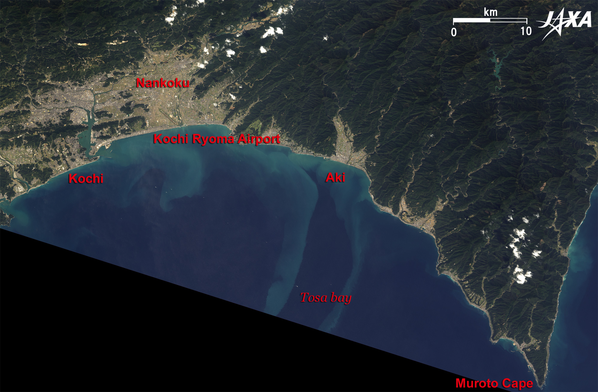
Figure 4 covers southern Shikoku, which faces on Tosa Bay. Kochi, Nankoku and Aki Cities are visible from the west side. Muroto Cape is visible on the right bottom. Muroto Cape Lighthouse on Muroto Cape has a 1,600,000 Cd light that can be seen for 48km, making it the best in Japan. Kochi Ryoma Airport is located 13km east of Katsurahama Beach. Kochi Ryoma airport was named in November 2003. A 2,500m-long runway was opened in February 2004, and the airport has regular services to Tokyo, Osaka, Nagoya, Fukuoka and Okinawa.
Explanation of the Images:
(Click the images twice to enlarge.)
AVNIR-2 has four observation bands. Figures 1 through 4 are produced by assigning red to Band 3 (610 to 690nm), green to Band 2 (520 to 600nm), and blue to Band 1 (420 to 500nm). The resulting images have natural coloring as if seen by the naked eye. Thus, the following colors designate ground objects.
| Dark green: |
Forests |
| Light green: |
Grass or farmland |
| Grey: |
City area or roads |
| Blue: |
Water area (sea and rivers) |
PRISM is an optical sensor for observing ground surfaces with visible and near-infrared signals in the 520 to 770 nanometer (one-billionth of a meter) band. The acquired image is monochrome. PRISM has three independent optical systems (telescopes) to acquire images for nadir, forward, and backward views at the same time so that terrain data, including altitude data, can be obtained. Only the backward images were used in this article.
The AVNIR-2 composite image was transformed into hue, saturation and intensity, and the intensity was replaced by the PRISM image. The hue, saturation and intensity data were then reversed into a color image. The result was a virtual 2.5m-ground-resolution color image. This kind of high-resolution color image, composed by combining the higher-resolution monochrome image and the lower-resolution color image, is called a pan-sharpened image.
Thus, colors represent the same features as in the above-mentioned AVNIR-2 image.
|
|