Seen from Space 2008
Kennedy Space Center Has Launched "Kibo (Hope)"
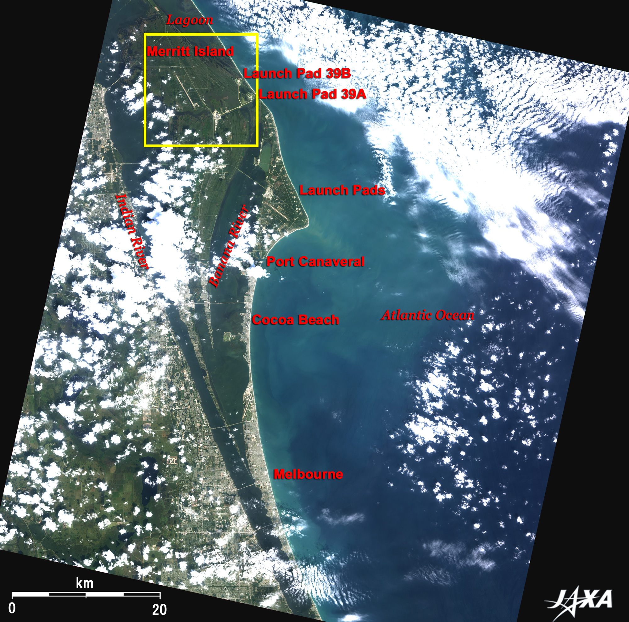
NASA's Kennedy Space Center is located on the east coast of central Florida, 80km east of the Orlando International Airport, the busiest airport in Florida. Kennedy Space Center was built on Merritt Island, a large sandbar bounded by a coastal lagoon on the north, the Indian River on the west, and the Banana River on the east. Cape Canaveral Air Force Station (CCAFS) is located on the triangular cape on the east of Banana River. Many launch pads are visible along the seashore facing the Atlantic Ocean. These were used to launch Atlas and Titan rocket boosters for the manned Mercury or Gemini Programs. Even today, they are still used to launch unmanned vehicles. Port Canaveral, the port of call for large cruisers that sail the South Atlantic Ocean to the Caribbean Islands, is visible south of the cape. From the port, a beach resort area extends across the great reaches of coastal sandbars down to the cities of Cocoa Beach and Melbourne. Further to the south is Miami, the largest city in the State of Florida, 280km south of Melbourne. The area around Kennedy Space Center is a wetland, most of which is a restricted area to ensure safety and protect the environment. It is also a wild-life preserve for large birds of prey and alligators.
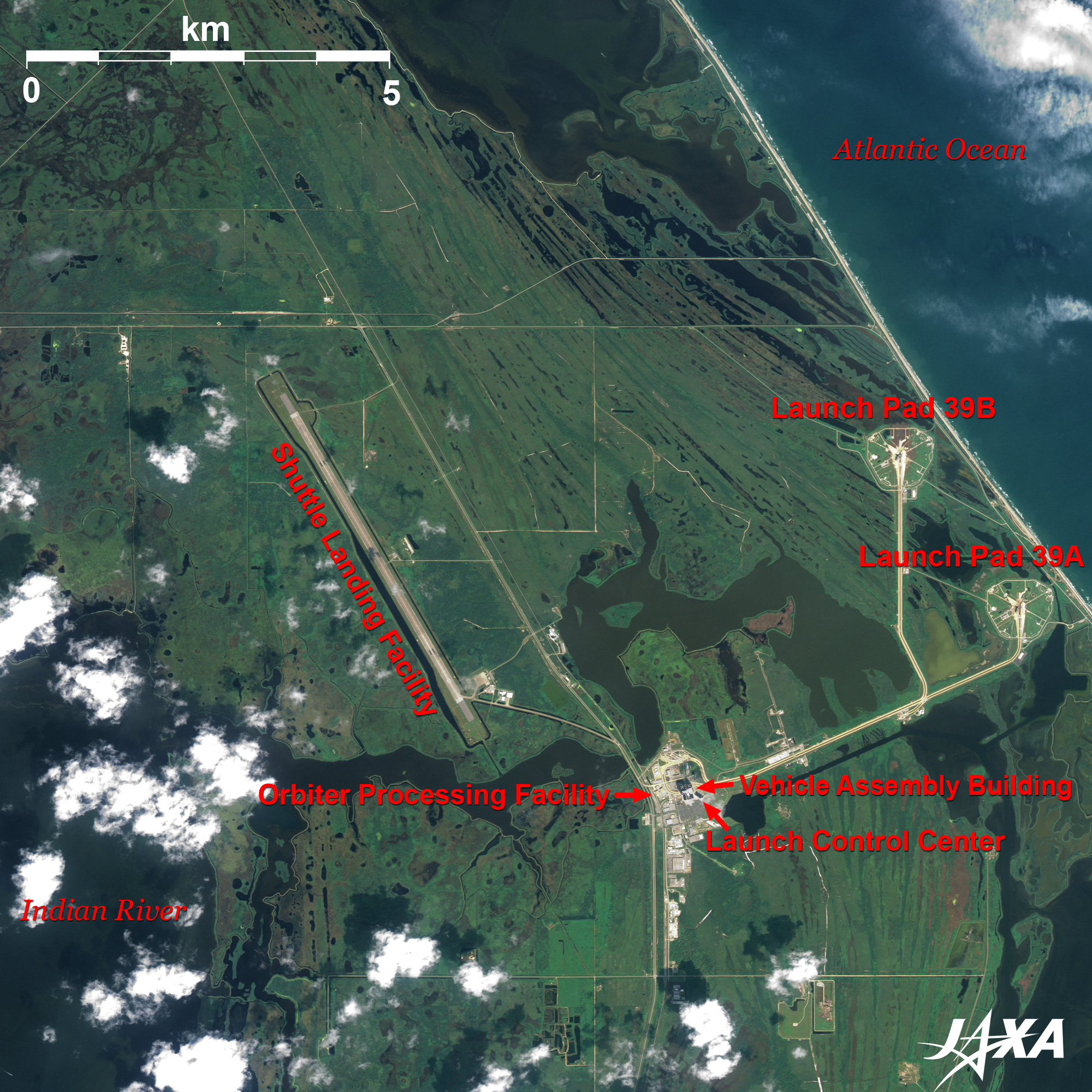
Launch pad 39A was used for the 1J mission, as well as for launching the first Space Shuttle, Colombia (STS-1), on April 12, 1981. In the middle left of the image, the gray runway running from northwest to southeast is the 4,572m long, 91m wide Shuttle Landing Facility. The area is about twice as large as the normal airport runway, with a 305m long paved overrun area at each end. The Vehicle Assembly Building (VAB), Launch Control Center (LCC), and Orbiter Processing Facilities (OPF) are located between the launch pads and the landing facility. At 160m high, 160m wide and 220m deep, the VAB is one of the largest buildings in the world. After assembly in the VAB, the Shuttle is transported vertically on a platform aboard the Crawler Transporter, traveling a slow 1.6km/h to launch pad 39A or 39B along a 6km long road. The Launch Control Center is a four-story building that serves as the computerized brain of launch pad 39. After landing, Space Shuttle is towed to the Orbiter Processing Facilities west of the VAB. After the remaining fuel is drained and the mission equipment is removed, the final strict checkout and tests are performed to prepare for the next flight mission. Japanese missions on the Space Shuttle began with the Space Experiments with Particle Accelerators (SEPAC). Five Japanese astronauts have flown aboard the Shuttle; Mamoru Mori was the first in 1992 followed by Chiaki Mukai, Koichi Wakata, Takao Doi and Soichi Noguchi. Three new astronauts, Akihiko Hoshide, Satoshi Furukawa, and Naoko Yamazaki, joined JAXA, and Kibo will be carried to ISS by three Shuttle flights. Full-fledged utilization of Kibo attached to the International Space Station will soon be realized.
Figs. 2. PRISM is an optical sensor for observing ground surfaces with visible and near-infrared signals in the 520 to 770 nano-meter (one-billionth of a meter) band. The acquired image is monochrome. PRISM has three independent optical systems (telescopes) to acquire images for nadir, forward, and backward views at the same time. Only the nadir image was used in this article. The above AVNIR-2 composite image was then transformed into hue, saturation and intensity, and the intensity was replaced by the PRISM image. The hue, saturation and intensity data were then reversed into a color image. As a result, a virtual 2.5-m ground-resolution color image was obtained. This kind of high-resolution color image, composed by combining the higher resolution monochrome image and the lower resolution color image, is called a pan-sharpened image.
|