Seen from Space 2008
Largest commercial city in Vietnam - Ho Chi Minh
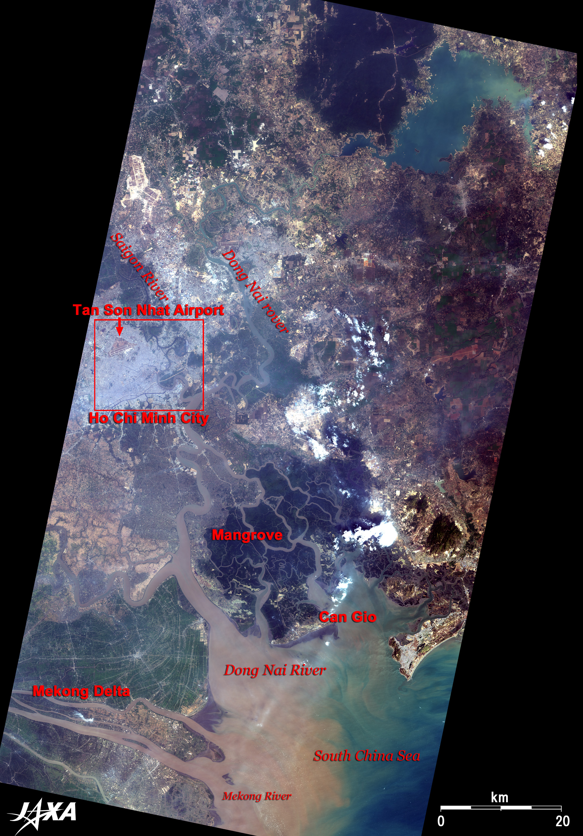
Ho Chi Minh City is located in southeast Vietnam and originated as a small fishery village known as Prey Nokor (meaning a forest city in Khmer). A dark-purple mangrove forest faces the South China Sea and expands to the right bank of Dong Nai River's mouth. It is specified as a preservation area (about 75,000 hectare) of mangrove trees, which is contrasted to a green cultivated land on the Mekong River delta of the opposite bank. The large lower stream of the Dong Nai River that originates in Dong Nai province, flows beside Ho Chi Minh City and empties into the South China Sea. The South China Sea along the mouths of Mekong River and Dong Nai River looks dark brown due to dirt and sand carried by these rivers.
The population of Ho Chi Minh, the largest commercial city in Vietnam and called Saigon till 1975, is 6.1 million (twice as large as the capital city Hanoi according to the HP of the Ministry of Foreign Affairs of Japan, as of February 2008). The population is increasing year by year. The beautiful building-dotted city has developed along the west side of Saigon River, and was once called "Paris in the East" due to the French influence. Typical buildings include the City Post Office, Saigon Church (Saigon Notre-Dame Basilica) and Reunification Palace. The City Post Office is one of the precious cultural properties of buildings in the colonial style and was built during French colonial days at the end of the 19th century. The interior has classical arches. A map of Saigon and its vicinity in 1892 is painted on the wall on the right-hand side of the entrance. A communication network connecting South Vietnam and Cambodia in 1936 is painted on the wall on the left-hand side. Saigon Church, located near the City Post Office, is a red brick Catholic church built at the end of the 19th century. Two 40-m-high steeples with classical style and long history rise into the sky. It has a solemn gothic style interior and an icon of the Virgin Mary at the front. Many devout Christians overflow the church on Sunday. Reunification Palace was the old presidential residence in the era of the Republic of South Vietnam.The present building was built in 4 years from 1962 and has more than 100 rooms. The Ho Chi Minh City (Tan Son Nhat) International Airport is an air gateway, and Saigon Port is the biggest sea gateway in Vietnam. Saigon Port does not face the sea. It is located on the Saigon River, a branch of the Dong Nai River, 80km upstream from the mouth of the Dong Nai River. The southern coastline downstream of the delta has heaps of mud so it is shallow and unsuitable for berthing large ships. The land gateway is the Saigon Station of the Vietnam North-South Railway. Passenger trains connecting with Ha Noi arrive and depart here, and the neighboring yard is for freight trains. Ben Thanh Market, established in 1914 and the biggest market in Ho Chi Minh City, is visited by several tens of thousands of shoppers and travelers everyday and is necessary for the life of the people. Cholon, a China town with Binh Tay Market, is located 5km to the west of the central city. The din and bustle, the large stock of goods, and the large scales of both markets are the real surprises. Foods and products from the harvest of the Mekong delta are gathered there. Free competition based on a market economy following the Doi Moi policy provides the city's vitality for expansion. "Government protocol for a partial change of management in certain fields for Ho Chi Minh City" was promulgated in December 2001. Ho Chi Minh City was granted the right to decide by itself issues of land management, budget management, reorganization of administrative systems, etc. without the approval of the central government. In accordance with this protocol, Ho Chi Minh City is playing a major role in introducing some pilot programs for improving the business environment, especially the foreign investment environment. Today, skyscrapers and foreign billboards dot the landscape, smart shops and restaurants are often opened, and many cars and motorbikes fill the streets and rotaries. The big Ho Chi Minh City continues to energetically rise and develop.
|