| |
 |
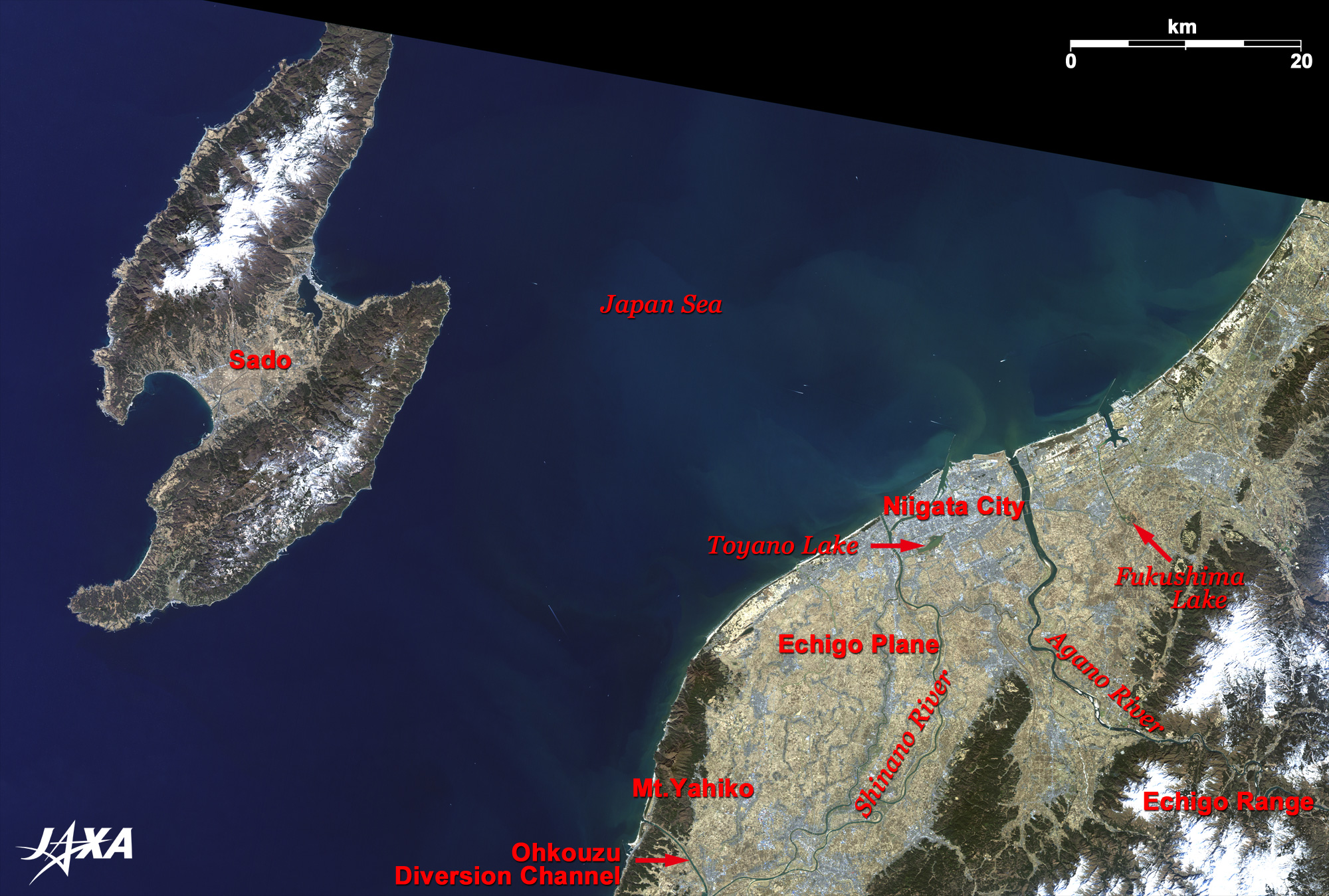
| Fig. 1. Vicinity of Niigata City |
Figure 1 depicts Niigata City and its vicinity as observed in February 2007. Echigo plain is located between the Japan Sea and the Echigo mountain range. This area was once a marshland with many lagoons, formed by deposited sediment from the mouths of the Sinano and the Agano rivers that empty into the Japan Sea. Recently, people have reclaimed new fields and developed well-drained paddy fields by excavating Ohkouzu and Sekiya diversion aqueducts and changed the landscape. Traces of the large marshland only remain at Toyano and Fukushima lagoons today, which are now important feeding grounds for migrating birds.
The Sinano River flows leisurely from south to north, meandering and branching off in Echigo plain and pouring into the Japan Sea. It is the longest river (367 km) in Japan. It originates on the borders of Saitama, Yamanashi, and Nagano Prefectures, and its name changes to the Chikuma River in Nagano Prefecture. Agano River, having the largest water flow in Japan, originates near the borders of Fukushima and Tochigi Prefectures, collects thaw water from Inawashiro Lake and Ozenuma Lake, and flows into Echigo plain. Niigata City developed at the mouths of the Shinano and the Agano rivers, where the coast line gently curves from north to south. The grey area along the coast is the downtown area. Yahiko-yama (mountain) area (visible in the lower middle of the figure) is a religious site worshipped as god precincts. Sado-gashima Island, famous for goldmines that financed the Edo feudal government (17th to 19th century), is seen in the offing. Sado-ga-shima is large enough (about twice the size of Tanegashima Island) that it had long been an independent province of Japan as Sado-no-kuni since the 7th century and preserves many traditional cultures such as Nogaku theatre, marionette performances, and Ondeko (demon drum).
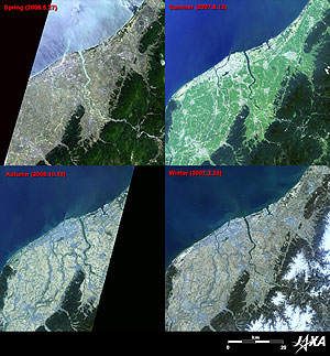 |
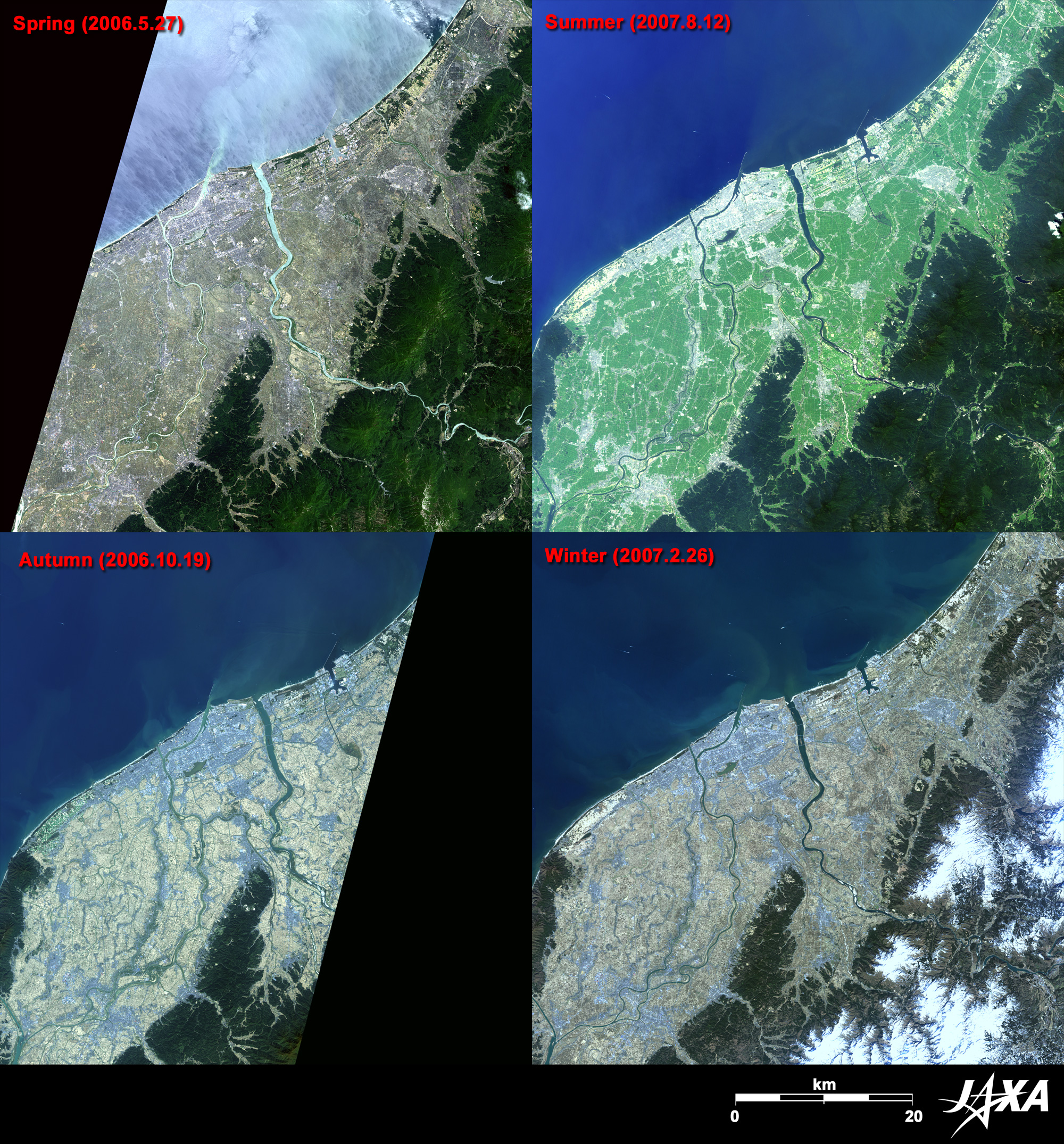
| Fig. 2. Seasonal Views of Echigo Plain |
Figure 2 compares seasonal views of Echigo plain. Echigo plain is soft green in spring, and a torrent of thaw water of the Shinano and the Agano Rivers empties into the Japan Sea. When summer comes, Echigo plain, basking in strong sunlight, disguises itself as a whole surface of green fields, and dyes to golden ears of rice in autumn. The figure very clearly reveals the changing faces of monocropping paddy fields. The winter image in the lower right of the figure depicts a tannish plain with no snow coverage. The weather was unusually warm in February 2007.
 |
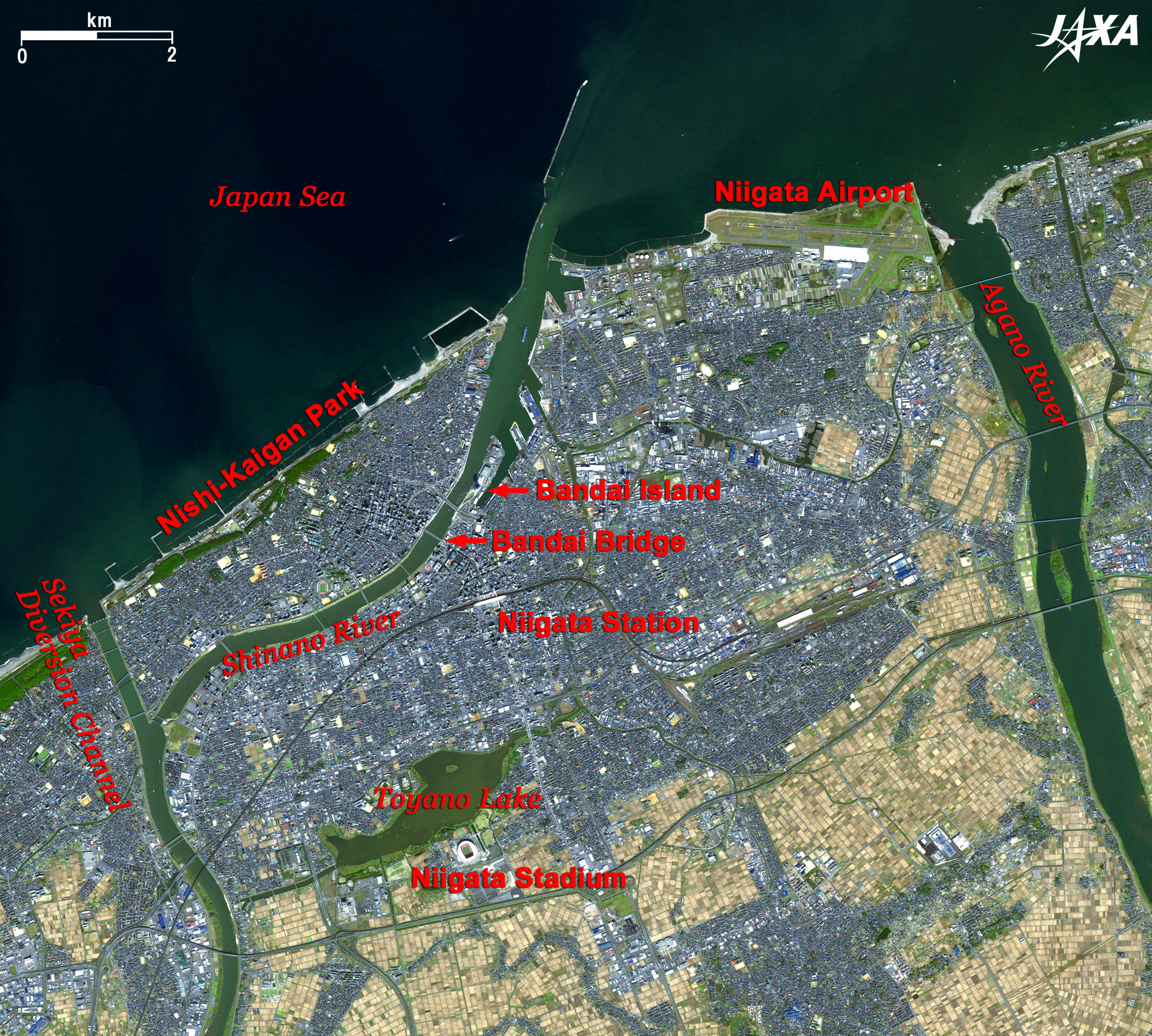
Fig. 3. Close-up of Niigata City
Niigata (kmz, 4.25MB, Low Resolution) as seen on Google Earth. |
Figure 3 presents a close-up image of the urban area of Niigata City (often called "Lagoon City") captured in October 2006. This satellite image pictures the Shinano River gently flowing in the downtown area and the Agano River grandly flowing in the suburbs, which creates the cityscape together with many bridges spanning the rivers. Bandai Bridge over the Shinano River (second bridge from the river mouth) is the symbol of Niigata City. This beautiful bridge connecting six arches is designated as an important cultural asset. Toki Messe (140 m in height), the tallest building on the west coast of Japan, towers over a sandbar called Bandai Island beside the bridge. From the observation deck on the top floor, you can see a grand view of Echigo Plain and the Shinano River spanned by the gracious Bandai Bridge, as well as the Japan Sea, Sado-gashima Island, and Yahiko-yama. Toriya-no-gata (lagoon) located on the opposite side across from the Niigata station and famous for cherry blossoms, is an oasis for the citizens. Albirex Niigata, the professional football team, plays their home games at the white-roofed football stadium visible on the lakeside. Orderly blocks of paddy fields in the suburbs create a beautiful geometrical pattern of changing tones before and after the rice harvest.
The green belt stretching along the coast on the left side of the figure is a Japanese black pine forest of the West Coast Park, which was landscaped on the sea-shore sand dune. This spot is famous for its beautiful sunsets over the Japan Sea.
A runway of the Niigata Airport is visible between the mouths of the Shinano River and the Agano River in the right of the figure. This unique airport has the most routes and regular flights to Far East Russia from Japan. Niigata City is the largest international city on the Japan Sea side, and is known as a "Government Designated Garden City." The image from space clearly portrays the direction of the future of this city.
Echigo (old provincial name of Niigata prefecture other than Sado-ga-shima) was unified (1556) and ruled by the warload Kenshinn Uesugi during the civil war period. The province broke up into small areas in the Edo era (1603 - 1867). However, Niigata Harbor prospered as a way port of Kitamaebune (shipping routes and ships in Japan during the Edo period), where products of the Echigo plain were distributed to ports all over the country. At the end of the Edo era, Niigata was assigned as one of the harbors to open to the world according to the "Treaty of Amity and Commerce between the United States and Japan." Having the fertile Echigo plain as a hinterland and developed as an important maritime product distribution center, Niigata is regarded as the "Capital of Water" fostered by the Shinano and the Agano Rivers.
Explanation of the Images:

Fig. 1 to 3 - Click the images twice to enlarge them.
AVNIR-2 has four observation bands. Figures 1 and 2 are produced by assigning red to Band 3 (610 to 690 nm), green to Band 2 (520 to 600 nm), and blue to Band 1 (420 to 500 nm). The resulting image has natural coloring as if seen by the naked eye. Thus, the following colors designate ground objects.
| Deep green or dark green: |
Forests |
| Light green: |
Farmlands (in spring) |
| Bright green: |
Farmlands (in summer) and grass fields (in spring and summer) |
| Light brown: |
Farmlands or grass fields (in autumn and winter) |
| Bluish grey: |
City area or roads |
| Blue: |
Water surfaces |
| White: |
Snow |
| Black: |
Areas with no data |
PRISM is an optical sensor for observing ground surfaces with visible and near-infrared signals in the 520 to 770 nano-meter (one-billionth of a meter) band. The acquired image is monochrome. PRISM has three independent optical systems (telescopes) to acquire images for nadir, forward, and backward views at the same time. Only the nadir image was used in this article.
The AVNIR-2 composite image was then transformed into hue, saturation and intensity, and the intensity was replaced by the PRISM image. The hue, saturation and intensity data were then reversed into a color image. As a result, a virtual 2.5-m ground-resolution color image was obtained. This kind of high-resolution color image, composed by combining the higher resolution monochrome image and the lower resolution color image, is called a pan-sharpened image.
Figure 3 is a high-resolution pan-sharpened image composed in this way.
|
|