| |
 |
Fig. 1 Suwa and Vicinity
Suwa (kmz, 3.99MB, Low Resolution) as seen on Google Earth
(Full Image) |
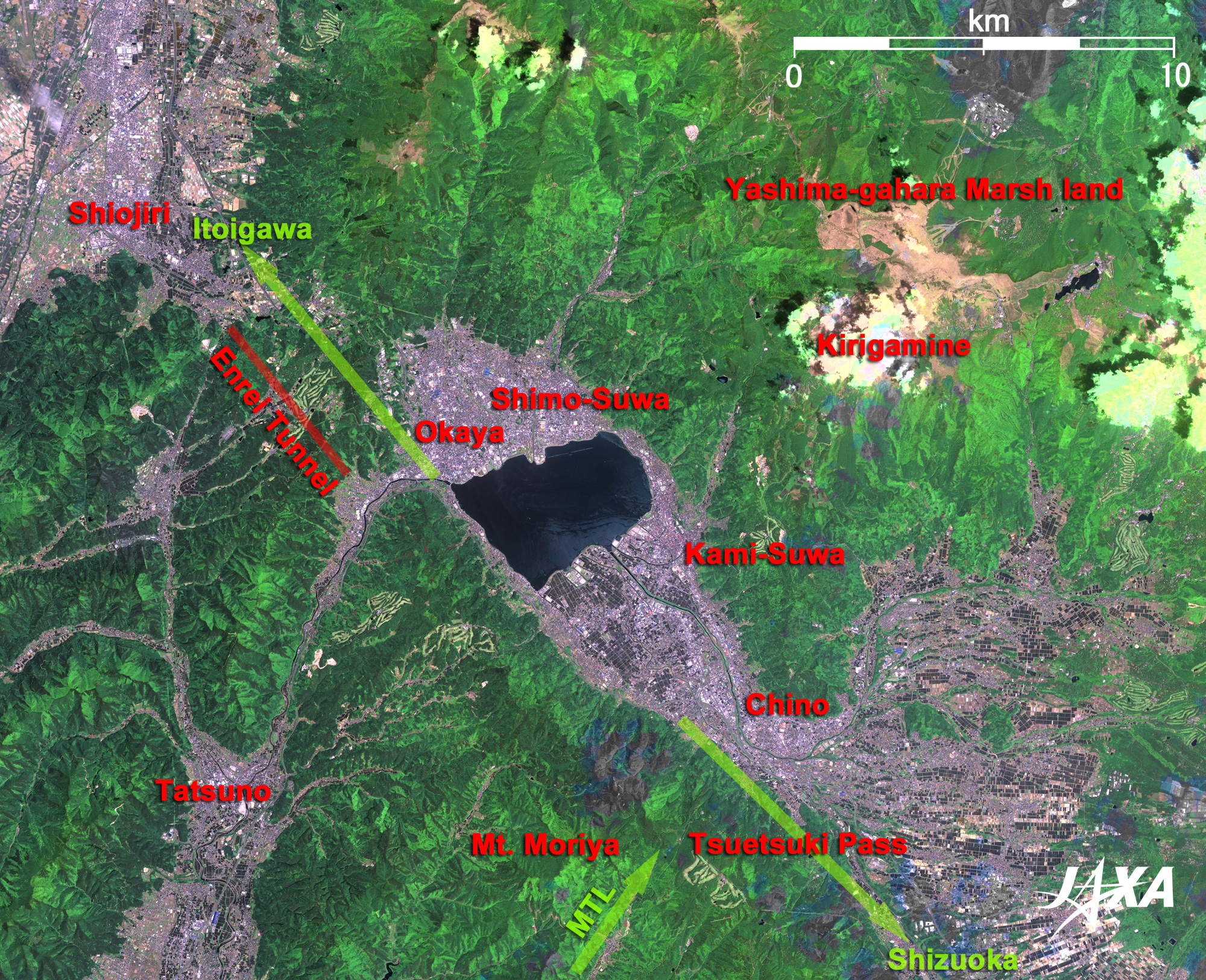
Figure 1 depicts Suwa and its vicinity as observed in June 2007. Suwa is a fault basin located in the center of Japan surrounded by Yatsugatake mountain range and Minami (south)-Alps mountain range. This is the birthplace of Yu-Hime, the heroine in NHK's (Japan Broadcasting Corporation's) TV saga "Fuu-Rin Ka-Zan" in 2007. The square-shaped lake at the center of the figure is Lake Suwa, which is 17km around and 7.6m deep and is also a source of Tenryuu River. About 200,000 years ago, Suwa basin was formed as a result of crustal movement of the Great Lift Valley of Japan (Fossa Magna) and the Median Tectonic Line (the longest fault in Japan, running 1,000km from the Kanto plain to Kyushu) during the last Middle Pleistocene era (about 700,000 years ago) and Late Pleistocene era (about 150,000 years ago). The central depression was filled with water and the fault lake was formed. In winter, the frozen lake is famous for expansion of ice belts and cracks across the lake accompanied by loud bangs, which is called Omi-Watari (God Passage). Due to the low average temperature at high altitude (759m) and meteorological conditions of a basin surrounded by mountains, its temperature varies more than 10°C, which results in the ice forms of Lake Suwa. The Median Tectonic Line running from the southwest (lower left) intersects the Itoigawa (Itoi river)-Shizuoka Tectonic Line running from the northwest (upper left) to the southeast (lower right) at about Moriya-san (Mt. Moriya) on the south (below) of Lake Suwa, and terminates near Tsuetsuki-toge (Tsuetsuki Pass). The northeast side of the Itoigawa-Shizuoka Tectonic Line facing Suwa basin is a fault cliff. Kirigamine highland, gently undulating from 1,500m to 1,900m in altitude, is located at the northeast (upper right) of Lake Suwa. This area was the center of obsidian culture of the Paleolithic Period of Japan. In the Middle Ages, warlords of the Genji family gathered here from all over the country and competed in hunting and horseback archery. In the Meiji Era (1868 - 1912), the highland area became famous as a scenic place where beautiful flowers bloom all over. In particular, Yashima-gahara Shitsugen (marsh land) located on the north of the highland was designated as a national special natural treasure in 1939 because it is a very rare high moor in Japan.
Enrei tunnel located at the northwest (upper left) of Lake Suwa was constructed in 1983 using state-of-the-art techniques of that time. This tunnel cut the travel distance and time between Shiojiri and Okaya from 27km and 31 minutes of the older Tatsuno route to 11km and 8 minutes.
 |
| Fig. 2 Close-up of the Northwest Side (Simo Suwa) of Lake Suwa |
 |
| Fig. 3 Close-up of the Southeast Side (Kami Suwa) of Lake Suwa |
 |
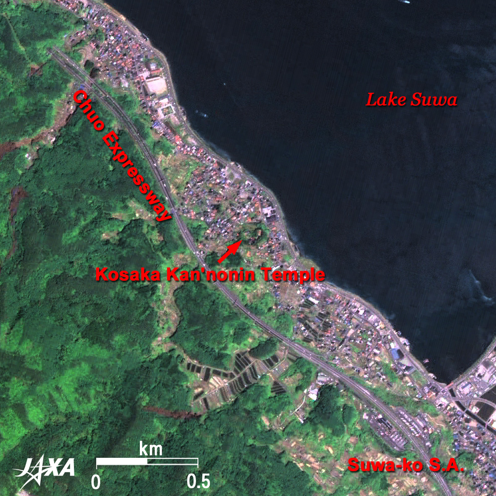
| Fig. 4 Close-up of the Southwest Side of Lake Suwa |
Figures 2 to 4 present close-up images around Lake Suwa. On the northwest side of Lake Suwa (Fig. 2) is Simo (lower) Suwa, and on the southeast side (Fig. 3), is Kami (upper) Suwa. Suwa Taisha (Suwa's Great Shrine), i.e. the Suwa's Great Gracious God which spread all over Japan as a leading war god originating in eastern Japan after medieval times, consists of two groups of shrines, Kami-sha (Upper Shrine including Hon-miya (Main Shrine) and Mae-Miya (Front Shrine)) on the Kami-Suwa side, and Shimo-sha (Lower Shrine including Aki-Miya (Autumn Shrine) and Haru-Miya (Spring Shrine)) on the Shimo-Suwa side. They can also be seen in the figure. Feudal lord Shingen Takeda, who appears in "Fuu-Rin Ka-Zan," prayed for victory to Suwa Taisha before every battle.
Nagano (alias Shinshu) prefecture is famous in Japan for hot springs, and Kami-Suwa area is the most famous of all. The greatest geyser in Japan shoots up to 50m and is located on the Suwa lakeside. A hot spring for feet was constructed in JR (Japan Railways) Kami-Suwa Station in 1986. Visitors can enjoy a very unique highway hot spring in the Suwa rest area of Chuo-expressway.
The castle ruins visible on the Suwa lakeside are the remains of Takashima castle built 400 years ago and called "Suwa's Floating Castle," which was once considered as impregnable. The feudal lord Suwa, who also appears in "Fuu-Rin Ka-Zan," usually resided at the forts in the mountains located at Kuwahara ruins about 2km southeast and Uehara ruins about 4km southeast.
Osaka Kan-non-in (goddess of mercy) is located on the southwestern Suwa shore (Fig. 4). Yorishige Suwa, the head of local ruling family of Suwa was overthrown by Shingen Takeda. Yorishige's daughter Yu-Hime was then required to become a concubine of the foe Shingen and had his son, Katsuyori, who later became Takeda's family head. After that, Yu-Hime was sent back to Suwa and ended her short life of 25 years there. As legend goes, Shingen's underwater tomb is in Lake Suwa. According to the Koshu style record of military exploits of Takeda family (Koyo Gunkan) compiled in the Edo era (1603 to 1867), Shingen's will stated that his body was to be suited with armor after his death and sunk in Lake Suwa. A geographical survey was actually conducted with sonar at the bottom of the lake in 1986. A lozenge, 25m on a side, was discovered at bottom of the lake, and there was discussion at that time that it might be Shingen's underwater tomb.
Throbbing historic romance is still alive in geographically complex Shinshuu-Suwa.
Explanation of the Images:

Fig. 1 to 4 and the full image. Click the images twice to enlarge them.
PRISM is an optical sensor for observing ground surfaces with visible and near-infrared signals in the 520 to 770 nano-meter (one-billionth of a meter) band. The acquired image is monochrome. PRISM has three independent optical systems (telescopes) to acquire images for nadir, forward, and backward views at the same time. Only the nadir image was used in this article.
AVNIR-2 is equipped with a pointing function by which it can shift its observation area perpendicular to ALOS's direction of travel and has four observation bands. The composite images are usually produced by assigning red to Band 3 (610 to 690nm), green to Band 2 (520 to 600nm), and blue to Band 1 (420 to 500nm). The AVNIR-2 composite image was then transformed into hue, saturation and intensity, and the intensity was replaced by the PRISM image. The hue, saturation and intensity data were then reversed into a color image, yielding a virtual 2.5m ground-resolution color image. This kind of high-resolution color image, composed by combining the higher-resolution monochrome image and the lower-resolution color image, is called a pan-sharpened image.
Figures are high-resolution, pan-sharpened images composed this way. The resulting images have natural coloring as if seen by the naked eye. Thus the following colors distinguish the ground objects.
| Khaki or brown: |
Bare ground |
| Green: |
Forests |
| Bluish grey: |
City area or roads |
| Dark Blue: |
Water surfaces |
| White: |
Clouds |
|
|