ページの先頭です。
本文へジャンプする。
【Important Notices】This page is an archive page of information published in the past. Since the update has been completed, it may contain broken links or outdated information. For the latest information, please use the new site Earth-graphy (earth.jaxa.jp).
ここからサイト内共通メニューです。
サイト内共通メニューを読み飛ばす。
サイト内共通メニューここまで。
ここから本文です。

Seen from Space 2007

Music and Habsburg dynasties in Vienna

 
Fig. 1 Vienna and its vicinity
Figure 1 depicts Vienna (in German, Wien; population about 1.6 million) and its vicinity. It is the capital of Austria and was a Roman frontier camp (Vindobona) along the Danube River (in German, Donau) guarding the Roman Empire against Germanic invasion. Vienna prospered under the Habsburg reign (12th to 19th centuries) after the division of the Roman Empire. Vienna is not only the capital but also one of nine states in Austria. The Danube River originates in the Northern Alps in southwest Germany and flows into the Black Sea in Romania. It is the second longest river (2,900km) in Europe, following the Volga River. It is regrettable that the current Danube River, especially midstream and downstream, is environmentally polluted and presents a far different image than the Blue Danube, a waltz written by Johann Strauss the Younger 140 years ago.

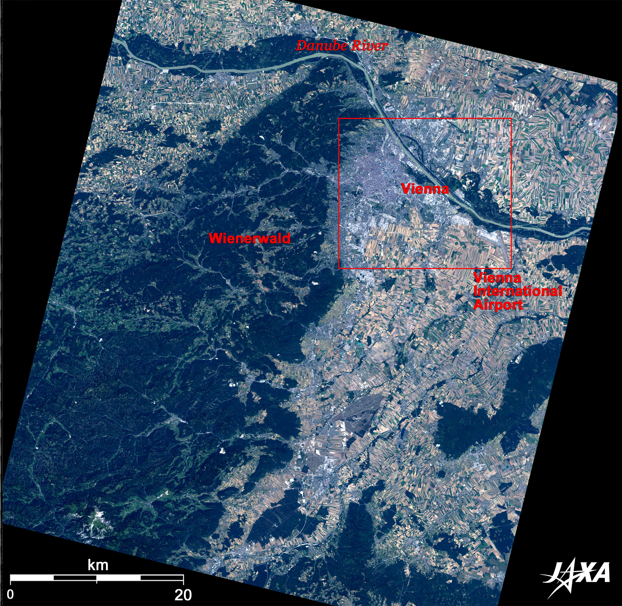
The deep-green area at the left of figure is the vast forest of Vienna (Wienerwald) including wine fields. Vast fields also appear in the upper right of the figure. These green areas are blessed with rich nature. Many European towns developed along rivers, just as Vienna developed between of the Danube River and the Vienna forest. This location was easily defensible against foreign enemies.
Vienna has been loved by many musicians. It is said that Beethoven composed Symphony No. 6 Op. 68 "Pastoral" in the forest of Vienna. The white area in the right of figure below the Danube River is the Vienna International Airport. Located 20km from central Vienna, it is a hub airport in Europe and has many airline routes.

Fig. 2 Suburb of Vienna
Figure 2 depicts the suburbs of Vienna. You can see the Vienna International Centre, also known as UNO-City, a major UN site along with New York and Geneva, liea between arc canal in the upper Danube River and the river. Many international organizations are located in Vienna, including the Permanent Mission of Japan to the International Organizations in Vienna, United Nations Office at Vienna (UNOV), Organization of the Petroleum Exporting Countries (OPEC), and the International Atomic Energy Agency (IAEA).
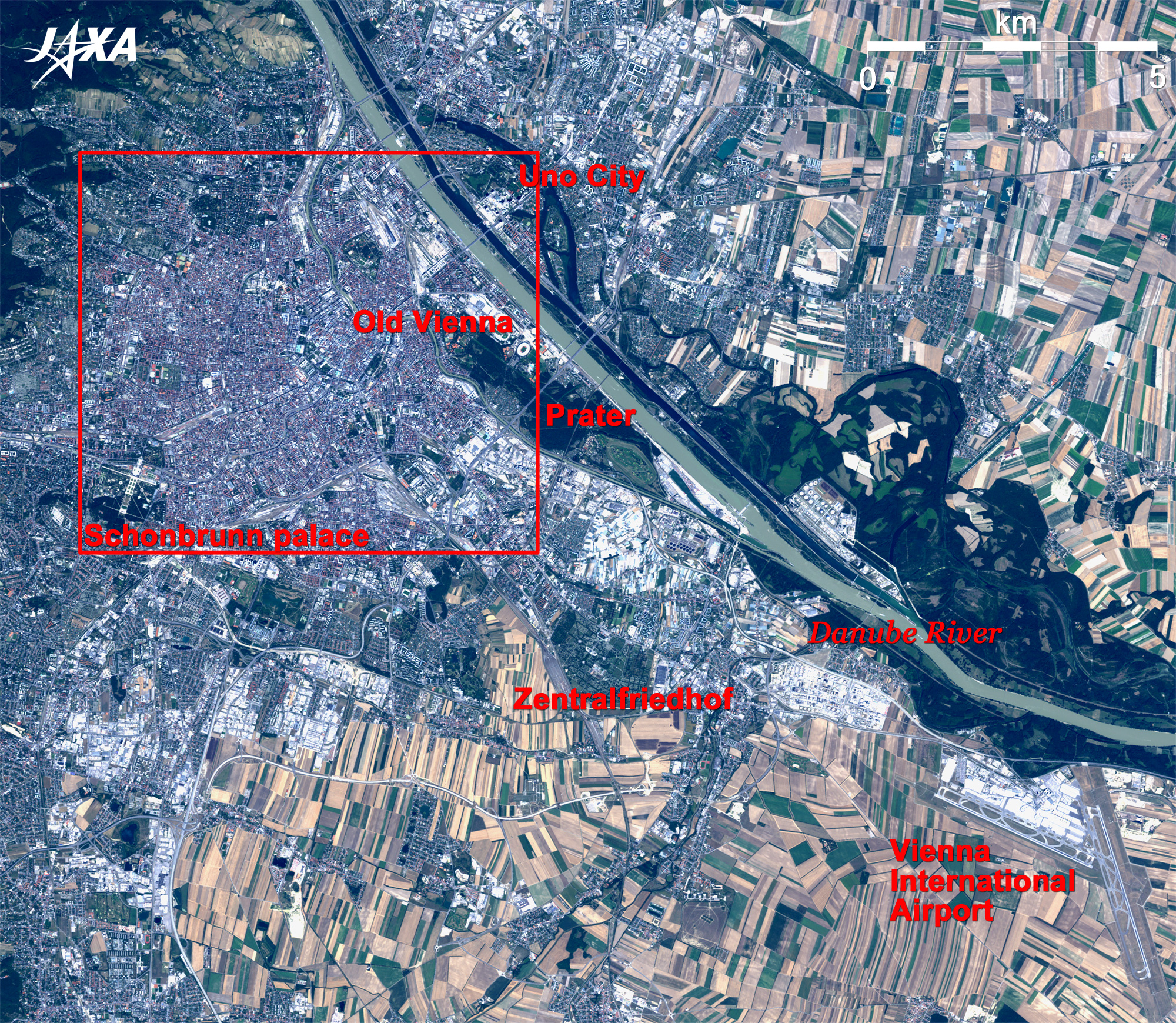
You can also see another canal on the opposite side. It is the old city of Vienna. The large green area to the right of the old city is Prater. It was an old hunting ground but is now a place of relaxation and recreation for citizens of Vienna after being opened to the public by Emperor Joseph II in the 18th century. Vienna's Prater Park includes the Giant Ferris wheel that appeared in the British suspense film, The Third Man, which was set in Vienna.
The Central Cemetery (Zentralfriedhof) of Vienna lies between central Vienna and Vienna International Airport; it is the burial site of many musicians, including Beethoven, Schubert, Brahms, and Johann Strauss I and II, and it also has the Mozart memorial.
Forming a cross in the left of the figure is Schönbrunn Palace, a detached summer palace of Habsburg monarchs. The palace was built in the Baroque Architecture style by Emperor Leopold I in a hunting woods in 1695, and then remodeled in the Rococo style. Schönbrunn Palace was added to the list of World Cultural Heritage sites of the United Nations Educational, Scientific and Cultural Organization (UNESCO) in 1996.

Fig. 3 Central Vienna
Vienna (kmz, 4.24 MB, Low Resolution) as seen on Google Earth.
The circle visible below the Danube canal in Fig. 3 is a 5km loop road called the Ring. It is the trace of a castle wall. The Ring surrounds the old city of Vienna and was also added to the list of the World Cultural Heritage sites of the United Nations Educational, Scientific and Cultural Organization (UNESCO) in 2001. Vienna city is composed of 23 districts (Bezirke). The Ring encompasses the first district, Innere Stadt. Many famous art facilities are located in the Innere Stadt. The largest Gothic style cathedral in Austria, St. Stephen's Cathedral (Stephansdom), is located at the center of old city. It has as its symbols a 137-meter tall south tower and a 61-meter tall north tower.
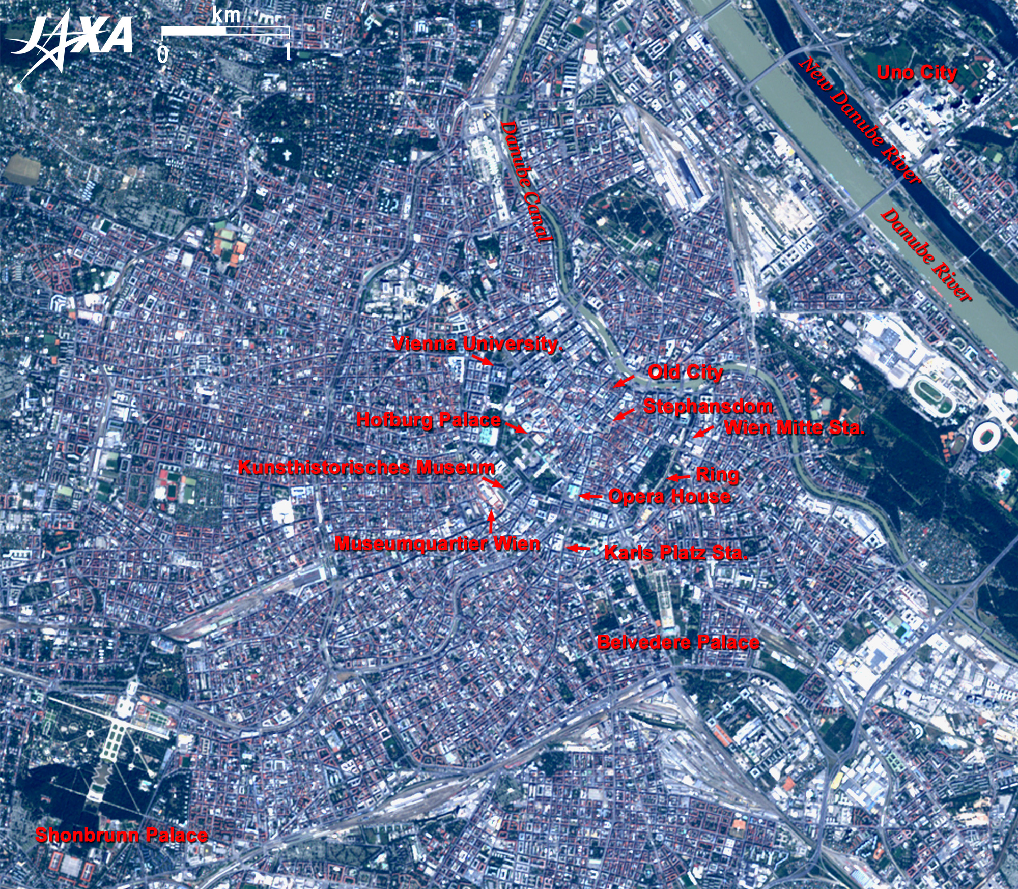
Hofburg Imperial Palace is visible to the west of the Cathedral. It was the imperial residence until the end of the Habsburg dynasty in 1918. There are 18 buildings and over 2,500 rooms in the vast site. There are plenty of places to see, starting with the oldest existing Swiss Court (Schweizerhof) from the 13th century, a gothic chapel (Burgkapelle) from the 15th century, Amalienburg from the 16th century, Leopold wing (Leopoldischiner Trakt) from the 17th century and so on. The Vienna Opera House, one of the most important opera houses in the world, is located southeast of the Palace.
The Museum of Art History (Kunsthistorisches) contains collections by the Habsburgs and is located southwest of the Palace across the Ring. You can see a large square named Maria-Theresien-Platz from the 16th century. A similar building on the opposite side of the square is the Natural History Museum (Naturhistoriches). MuseumsQuartier Wien including Leopold Museum is a major cultural composite facility in the southwest of the square.

The University of Vienna, the home of several Nobel Prize Laureates and founded in 1365, is located north of the old city. Karlsplatz station, a well-known example of Art Nouveau architecture, is visible at the bottom of the Ring. Wien-Mitte station is the most convenient way to commute, with a travel time of 16 minutes to Vienna International Airport by City Airport Train (CAT). Belvedere Palace (belvedere means beautiful view) is visible at the right bottom of the Ring. It was an Austrian Baroque style palace built by Prince Eugene of Savoy who defeated the Ottoman Turks. It has an upper Belvedere and a lower Belvedere, and both are museums now. A French-style garden lies between the two palaces, and a Sphinx is enshrined in the north garden.


Explanation of the Images:
Figs. 1 to 3 (Click the images twice to enlarge them.)
Satellite: Advanced Land-Observing Satellite (ALOS) (Daichi)
Sensor: Advanced Visible and Near Infrared Radiometer-2 (AVNIR-2)
Date: 1001 (UTC) on July 27, 2007
1142 (UTC) August 20, 2006 (AVNIR-2, Figs. 1 and 2)
Ground resolution: 10m
Map Projection: Universal Transversal Mercator (UTM)
AVNIR-2 has four observation bands. The composite images are produced by assigning red to Band 3 (610 to 690nm), green to Band 2 (520 to 600nm), and blue to Band 1 (420 to 500nm). The resulting image has natural coloring as if seen by the naked eye. Thus, the following colors designate ground objects.

Dark green: Forests
Light green, Ocher and Brown: Grass fields or farmland
Bluish grey: City area or roads
Red: Roofs of houses
White: Buildings
Blue and Gray Green: Rivers and Canals
Black: No data

Related Sites:
ALOS Research and Application Page
The fountain visible from space: Geneva, Switzerland
Munich: The capital of the German Federal State of Bavaria
Land, Seen from Space
本文ここまで。
image:Satellite Navigator
image:Satellite Applications and Operations Center(SAOC)
Earth Data Collection by JAXA Satellites
image:ページTOP