ページの先頭です。
本文へジャンプする。
【Important Notices】This page is an archive page of information published in the past. Since the update has been completed, it may contain broken links or outdated information. For the latest information, please use the new site Earth-graphy (earth.jaxa.jp).
ここからサイト内共通メニューです。
サイト内共通メニューを読み飛ばす。
サイト内共通メニューここまで。
ここから本文です。

Seen from Space 2007

Palace on Lake, Udaipur

 
Fig. 1 Vicinity of Udaipur
(Full Image)
Figure 1 depicts the vicinity of Udaipur in southern Rajasthan state in western India as acquired in March 2007. Udaipur is located 560km southwest of Delhi and on dried highlands. Rajasthan is the largest state in India and has three major scenic spots associated with colors. Jaipur is known as "Pink City" and is named after the surrounding red castle wall. Jodhpur is called "Blue City" after its blue house walls. Udaipur is referred to as "White City" and is named after its beautiful white buildings. Udaipur is 435km southwest of Jaipur and is located on dried land surrounded by the Thar Desert as can be seen in the figure.

Fig. 2 Central Udaipur
Udaipur (kmz, 2.57MB, Low Resolution) as seen on Google Earth.
Figure 2 depicts central Udaipur and two man-made lakes. Maharana Udai Singh built the capital of Mewar kingdom in 1568 to defend against Mughal Empire attacks. The City is known as Lake Town because of its dammed lakes. The king of Udaipur is called Maharana, but other kings in India are called Maharaja because he maintained independence of his kingdom during the Mughal Empire and English colonial periods.
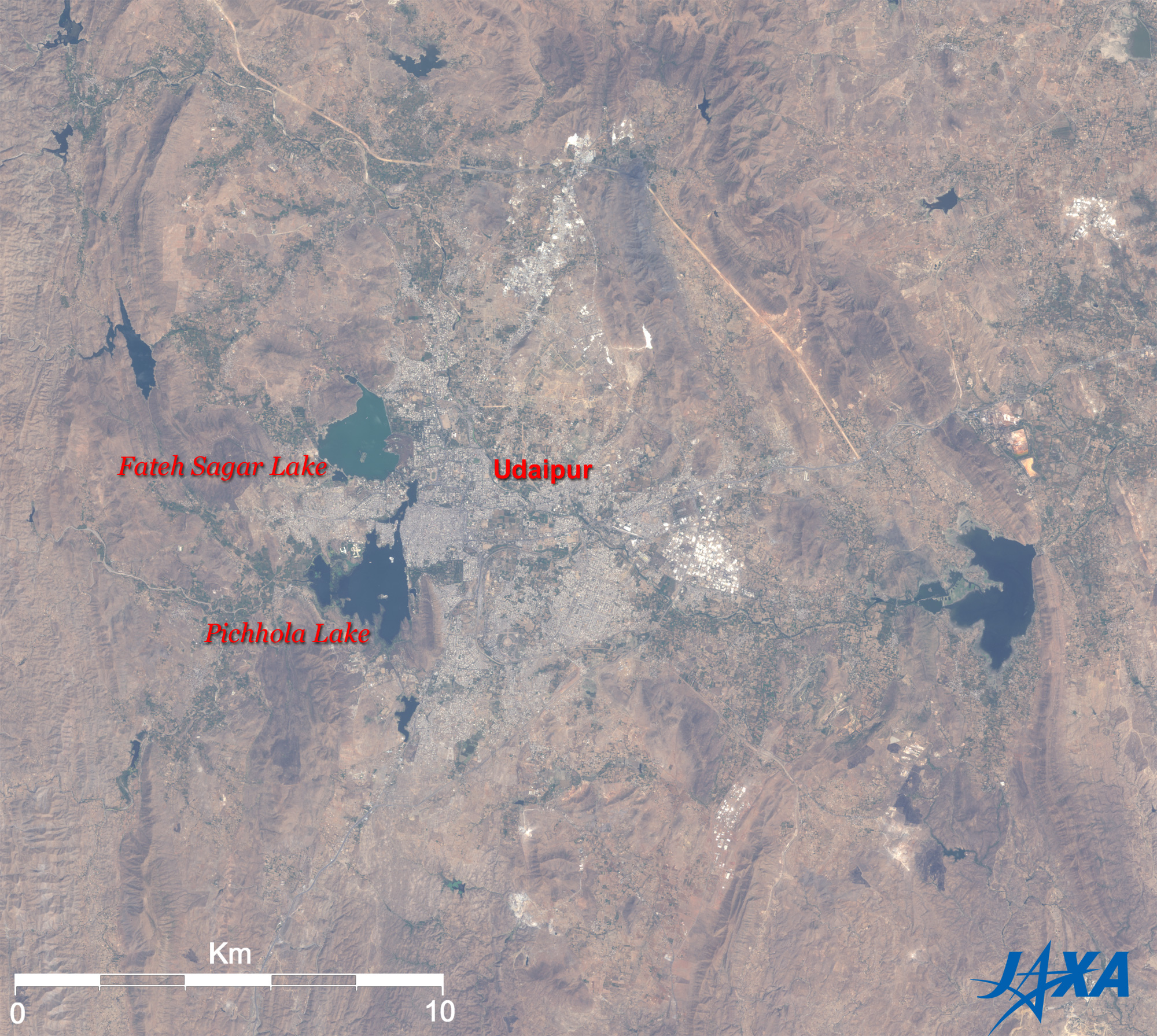
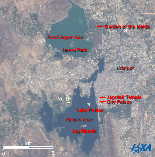
Lake Pichola is at the bottom (south) of the figure, and Fateh Sagar Lake is at the top (north). Lake Pichola is 4km by 3km wide. Jag Niwas Island is the white palace visible in the upper part of the figure. Lake Palace was built as a summer detached palace by the Maharana. Almost the entire island is made of marble and is now utilized for a hotel. It was the location for shooting the "007 Octopussy" film. Jag Manidr Island, in southern Lake Pichola, has a palace where Emperor Shah Jahan of the Mughal Empire once lived.
Fateh Sagar Lake was made when the dam burst due to heavy rain in 1678. Maharana Fateh Singh subsequently rebuilt and extended it. The large island in the middle of Fateh Sagar Lake is Grand Nehru Park, named after first prime minister Nehru. It has a flower garden and lotus pond. Udaipur Solar Observatory is also located in the middle of the lake and is one of the best locations in the world for observing the Sun. It is better suited for observing the Sun because there is little disturbance due to the Earth's heat and atmospheric scattering because it is located on the lake.
These lakes are weather-sensitive areas and have suffered heavy rains and droughts many times. Recently, there was heavy rain in 1975, and then lakes dried up in 2003 and 2005. People walked through the Observatory and Lake Palace after it had dried up. You can see from Fig. 2 that there is a lot of water this year.
Standing on the east bank of Lake Pichola is the City Palace where the Maharana currently lives. It was repeatedly extended and reconstructed until it has become the largest palace in Rajasthan state, measuring 240m east to west and 450m north to south. The palace is rich with marble and is open to the public as a museum. Jagdish temple situated in the entrance of the City Palace was constructed in an Indo-Aryan architectural style by Maharana Jagdish Singh in 1651. This temple is devoted to the Hindu God Vishnu, and the black stone, Jagannath, means the supreme god is enshrined.
You can see the Garden of the Maidens, Saheliyon-ki-Bari, on the east bank of Fateh Sagar Lake. This was built by Maharana Sangram Singh in the 18th century. This garden was a popular spot where royal ladies and maids came for picnics. The garden has beautiful landscaping with many fountains, kiosks, marble elephants, and lotus pools. However, the fountains are operated only for visitors.


Explanation of the Images:
(Click Figs. 1, 2 or the full image twice to enlarge them.)
Satellite: Advanced Land-Observing Satellite (ALOS) (Daichi)
Sensor: Advanced Visible and Near Infrared Radiometer-2 (AVNIR-2)
Date: 0549 (UTC) on March 29, 2007
Ground resolution: 10m
Map Projection: Universal Transversal Mercator (UTM)
AVNIR-2 has four observation bands. The composite images are produced by assigning red to Band 3 (610 to 690nm), green to Band 2 (520 to 600nm), and blue to Band 1 (420 to 500nm). The resulting image has natural coloring as if seen by the naked eye. Thus, the following colors designate ground objects.
Ocher or Brown: Desert or Bare ground
Green: Water surfaces or Grassland
Dark Blue: Water surfaces
Grey: City area, roads
White: Buildings
Black: No data

Related Sites:
ALOS Research and Application Page
The World's Most Beautiful Mausoleum, Taj Mahal in India
Land, Seen from Space
本文ここまで。
image:Satellite Navigator
image:Satellite Applications and Operations Center(SAOC)
Earth Data Collection by JAXA Satellites
image:ページTOP