| |
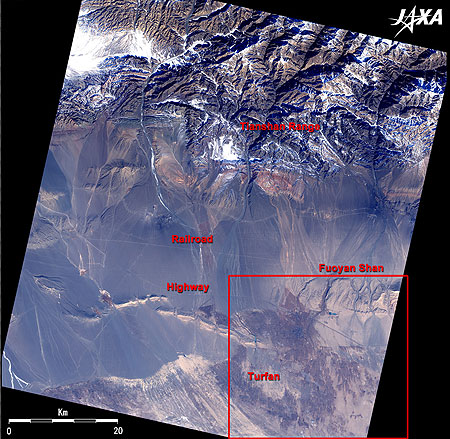 |
Fig. 1 Turpan, Flame Mountains and its vicinity
Flame Mountains (kmz,1.89MB,Low Resolution) is seen from Google Earth. |
Figure 1 depicts the vicinity of Turpan (or Turfan), an oasis city on the Silk Road with a population of 250 thousand. Turpan and the Flame Mountains are mentioned in the Chinese tale, Xīyóu Jì or Monkey. The images were acquired by the Advanced Visible and Near Infrared Radiometer-2 (AVNIR-2) on board the Advanced Land Observing Satellite (ALOS) Daichi in February 2007. The entire figure is brownish because it is a desert area, but the vast grape fields in Turpan in the lower right of the figure appear dark brown. This image was acquired in winter, so there is little green. However, Turpan is a fertile oasis city fed by snow-water from the Tian Shan range. Watermelons, peaches, hami gourds*, and over 6,000 kinds of grapes grow in the fields of Turpan. Thanks to snow-water from the Thian Shan range and underground irrigation canals called kārez all over the city (kārez prevent water evaporation by connecting wells at intervals of 20 to 30 meters), there is abundant water even though Turpan is in the desert. Turpan is located in the Xinjiang Autonomous Region of China's western region and occupies one sixth of China's area. It takes two hours on highway constructed in 1998 to travel from Turpan to Ürümqi, which is the capital of the Xinjiang Autonomous Region with a 2.1 million population and is located 180km northwest of Turpan across the Thian Shan range. It makes us feel that we are living in a completely different age from those who traveled the Silk Road across the desert on camels.
Flame Mountains is visible in the right of the figure. It is just same as the Flaming Mountain where Sūn Wùkōng (the Monkey God) and the Cow Devil fought for the Fire Fighting Fan in Xīyóu Jì. It is the symbol of Turpan and is called red mountain by the Uyghur. The highest peak is 850m above sea level. The Flame Mountains are not one mountain but a red sandstone surface spanning 100km in the shape of a folding screen. The surface of the Flame Mountains is carved by numerous rough lines, indicating that the mountains were formed by long-term diastrophism, weathering and erosion. It is now a desert area, but it once rained here. The temperature rises to 48°C, forming heat hazes. The shimmering lines of the mountain's red surface give it the name flaming mountains. However, it can also be very cold here, with temperatures ranging from -4 to -16°C. The best season for seeing Flame Mountains is summer, but you must be in good physical condition.
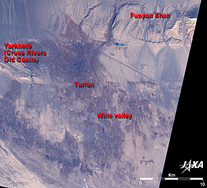 |
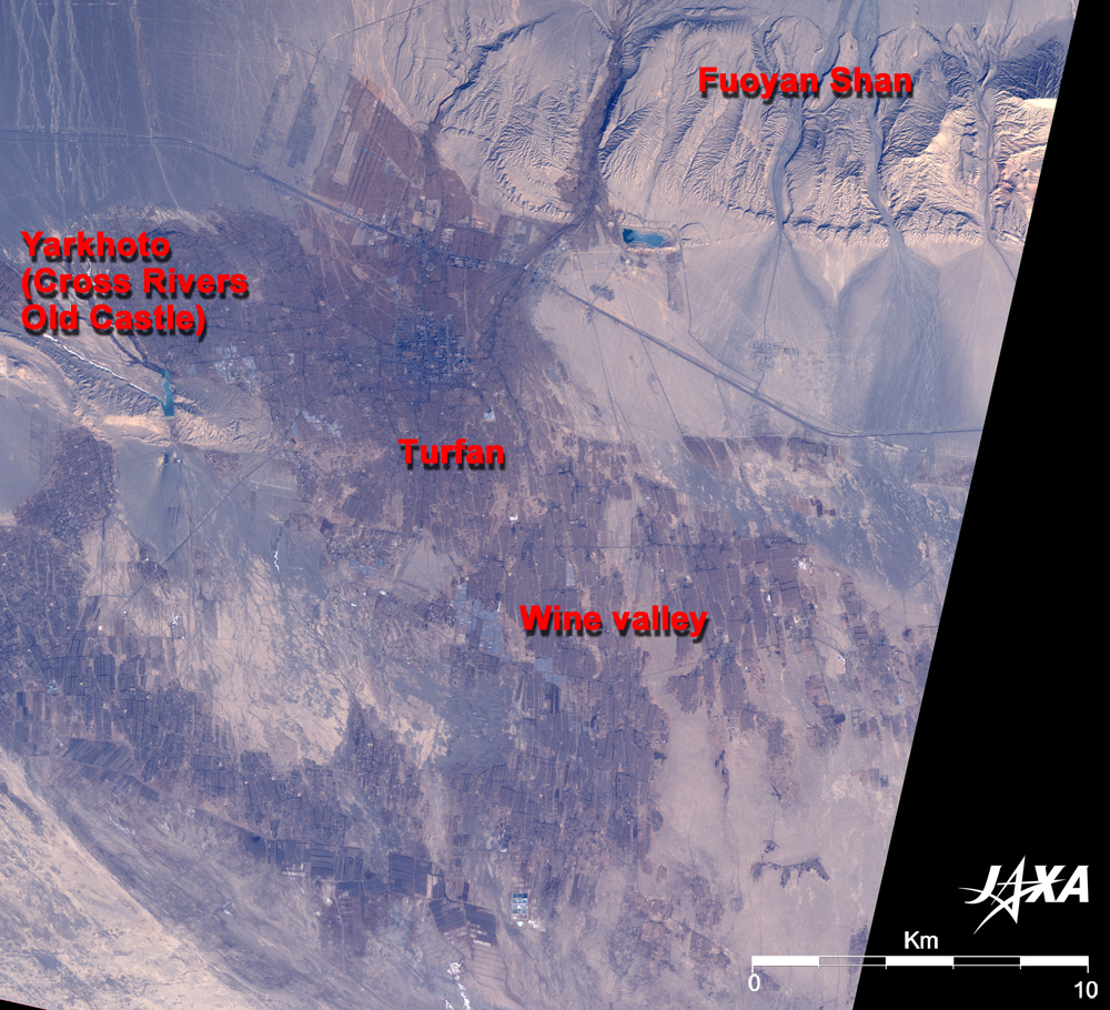
| Fig. 2 Close-up of Turpan |
Figure 2 presents a close-up of Turpan. The Kingdom of Gaochang in the vicinity of Turpan was prosperous in the 5th to 7th centuries. A famous Chinese Buddhist monk, Xuanzang, stopped here on the way to India. It said that the king of Gaochang, Qú Wéntài, believed in Buddhism and took lessons from Xuanzang. However, when Xuanzang visited there after visiting India for some years, the country was in ruins. The ruins of Gaochang castle lie 40km south of the current Turpan but are not visible in the figure. This castle was built up by sun-dried bricks including limbs of Tamarix (pinky flower) and grass. The destroyed castle is no longer visible after neighboring farmers took the bricks from the ruins for fuel and fertilizer.
An old castle similar to a big warship, Yar-Khoto, or Cross Rivers Castle, is visible in the left of Fig. 2 15km west of Turpan. It is part of the ruins of the Chechi Kingdom, which was prosperous together with Gaochang Kingdom and was one of 36 western countries in old China. The old castle was a secure fort carved into the table land and cliffs between two rivers. The Chechi Kingdom was destroyed by Gaochang Kingdom in the middle of fifth century, and the Gaochang Kingdom, in turn, was destroyed by the Tang. Subsequently, Yar-Khoto was a military fort of the Tang until the Mongolians destroyed it in the 14th century.
|
* hami gourd: Special product of Xinjiang Autonomous Region. The flesh of the gourd (melon) is orange, very crispy and sweet like watermelon. Hami is a city 360km east of Turpan. |
Explanation of the Images:
Figs. 1 and 2
AVNIR-2 has four observation bands. The composite image is produced by assigning red to Band 3 (610 to 690 nm), green to Band 2 (520 to 600 nm), and blue to Band 1 (420 to 500nm). The resulting image has natural coloring as if seen by the naked eye. The exposed rocks and soil look ocher, and the field looks dark brown, though it is hard to distinguish them because it is a desert area.
|
 |
|