| |
 |
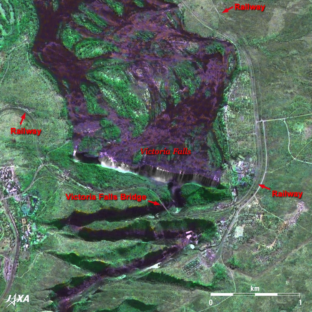
Fig. 1 Pan-sharpened Image of Victoria Falls
Victoria Falls (kmz,1.42MB,Low Resolution) is seen from Google Earth.
(Full Image) |
Figure 1 presents a pan-sharpened image of Victoria Falls. The figure was produced by combining images acquired by the Panchromatic Remote-sensing Instrument for Stereo Mapping (PRISM) on board the Advanced Land Observing Satellite (ALOS) "Daichi" in July 2006 and by the Visible and Near Infrared Radiometer (VNIR) on board the Japanese Earth Resources Satellite-1 (JERS-1) "Fuyo-1" in April 1997. An oblique image from the south was observed in order to see the waterfall better. The water runs high in April just after the rainy season.
Victoria Falls is one of the world's three major waterfalls. It is located in the middle of the 2,750km long Zambezi River flowing along the borders of Zambia and Zimbabwe in southern Africa to Mozambique, where it empties into the Indian Ocean. This waterfall is 1.7km (1 mile) wide and its falls range in height from 80m to 108m (360ft), which doubles the heights of Niagara Falls. The white clouds of spray rising from the waterfall basin and the vertical drop of water into the chasm are clearly visible in the figure. Its local name, "Mosi-oa-Tunya," means the smoke that thunders. The clouds of spray reach up to 400m high in rainy seasons and can be seen even from 50km away. The fantastic moon-bow emerges on nights of the full moon, and a spectacular rainbow can be seen in the daytime.
The full image depicts the dark Zambezi River meandering from left to right (west to east). Zambia is north of the river and Zimbabwe is south. Victoria Falls is located where the wide meandering river narrows and becomes zigzagged. Livingstone Airport in Zambia is visible in the upper part of the image and Victoria Falls Airport in Zimbabwe is in the lower right.
The first European to see the falls was David Livingstone, a Scottish explorer, who visited the falls in 1855. There were very few visitors to this area before a complex Victoria Falls Bridge (railway, road and sidewalks) spanned the river in 1905. Today, however, more than 300,000 tourists visit every year. The most common route from Japan to this waterfall is to Johannesburg (Republic of South Africa) via Hong Kong, and the nearest Victoria Falls Airport (Zimbabwe). It is a long journey, taking more than 20 hours including transit time. In 2004, there were 17,406 visitors from Japan to Zimbabwe (according to Japan National Tourist Organization research).
 |
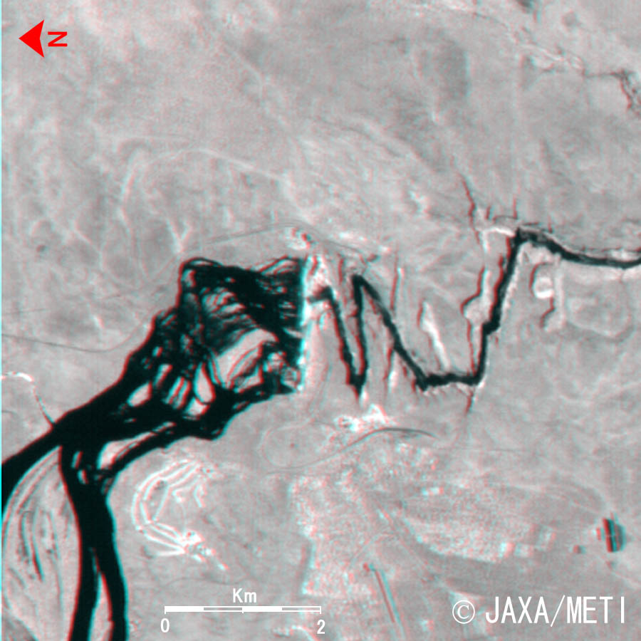
Fig. 2 Three-Dimensional View of Victoria Falls (North is to the left.)
(Staring at the image for a long time may cause eyestrain. A colored print is available in pdf format. Pdf files for the left and right eyes are also available.) |
Figure 2 is a 3D view centering on Victoria Falls. Rising clouds of spray hide the waterfall basin, but the zigzagged river can be seen flowing below the sheer cliff on the downstream side.
Victoria Falls was added to the World Natural Heritage list of the United Nations Educational, Scientific and Cultural Organization (UNESCO) in 1989. The Independent News, dated January 7, 2007, however, reported that UNESCO is now considering listing the site as "endangered" because excessive tourism has deteriorated the once prosperous resort. Furthermore, over-zealous developers are proposing to build 500 chalets in a national park overlooking the waterfalls.
Explanation of the Images:
Figs. 1, 2 and Full Image
PRISM is an optical sensor for observing ground surfaces with visible and near-infrared signals in the 520 to 770 nanometer (one-billionth of a meter) band. The acquired image is monochrome. PRISM has three independent optical systems (telescopes) to acquire images for nadir, forward, and backward views at the same time. The backward image was used here. VNIR is also an optical sensor to acquire nadir ground images with visible and near-infrared in three bands and a forward image in near-infrared to obtain three-dimensional view.
The composite images are usually produced by assigning red to the visible Band 2 (630 to 690nm), green to the near-infrared Band 3 (760 to 860nm), and blue to visible Band 1 (520 to 600nm) of VNIR. In Fig. 1, green is assigned to the sum of 60% of Band 2 and 40% of Band 3. The resulting images have natural coloring as if seen by the naked eye. The image was then transformed into Hue, Saturation and Intensity, and the Intensity was replaced by the PRISM image. The Hue, Saturation and Intensity data were then reversed into a color image. As a result, a virtual 2.5m ground-resolution color image was obtained.
This kind of high-resolution color image, composed by combining the higher resolution monochrome image and the lower resolution color image, is called a pan-sharpened image. The resulting image has natural coloring as if seen by the naked eye. Thus the ground objects are distinguished by the following colors.
| Dark green: |
Forests |
| Light green: |
Grass fields, farms |
| White: |
City area, roads or waterfalls |
| Deep purple: |
Water surfaces |
Figure 2 combines the forward (red) and nadir (green and blue) images of VNIR. The left eye sees the forward image and right eye sees the nadir image, which results in the right side corresponding to the satellite flight direction (south) and left side corresponding to north. Note that upward is north in Fig. 1, whereas the left-hand side is north in Fig. 2.
The backward view of PRISM is used for the full image.
|
 |
|