ページの先頭です。
本文へジャンプする。
【Important Notices】This page is an archive page of information published in the past. Since the update has been completed, it may contain broken links or outdated information. For the latest information, please use the new site Earth-graphy (earth.jaxa.jp).
ここからサイト内共通メニューです。
サイト内共通メニューを読み飛ばす。
サイト内共通メニューここまで。
ここから本文です。

Seen from Space 2007

Boston, Birthplace of USA and Cambridge, City of Universities

 
Boston (kmz, 1.47MB, Low Resolution) as seen on Google Earth.
(Full Image)
Figure 1 presents a close-up image of Boston, the state capital of Massachusetts, United States of America, and its vicinity as observed by the Advanced Visible and Near Infrared Radiometer-2 (AVNIR-2) on board the Advanced Land Observing Satellite (ALOS) "Daichi" in August 2006. The Charles River meanders from left to right in a gray urban area in the figure center and pours into the Boston Bay in the lower right. Cambridge is on the north side of the river, and Boston is on the south. The large airport facing the bay is the Logan International Airport where triple crossing runways and complex terminals are clearly visible. Many piers on the waterfront area jut out from the opposite bank. The white line extending from north to south in the city center on the west of the piers is the former Inter-state 93 (I-93), which had a world-class traffic problem and was the most congested highway in the United States. The Central Artery/(Third Harbor) Tunnel Project (commonly called the Big Dig Project), started in 1991 and is a grand project intended to ease congestion by making elevated I-93 an underground route, increasing the lanes, and converting the surface I-93 property into a park. Underground construction was almost completed by the end of 2004, but greening and the redevelopment of the I-93 property still looks ongoing.

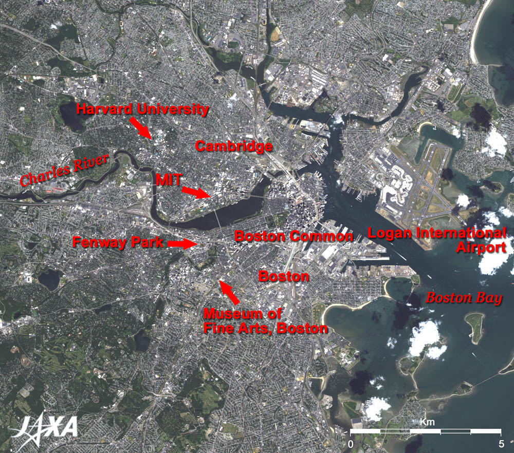
Islands in the Boston Bay are fringed with white sandy beaches, the natural charms of which might have attracted pilgrims who had come to the New World across the Atlantic Ocean.

Cambridge, named after the academic city in London, is located on the north side of the Charles River. Many bright students from all over the world come to this town. Harvard University has produced many leaders of every sector of society including politicians such as the late president Kennedy, and Massachusetts Institute of Technology (MIT) has produced a number of Nobel Prize scholars. Harvard University, established in 1636, is the oldest university in the United States. The campus is located where the Charles River winds to the north, and blue-roofed school buildings are visible in its center. There is another campus in Boston on the opposite bank of the Charles River where the Harvard Football Stadium can be seen. The MIT campus is located in a green square along the Charles River, where the large Kresge Auditorium with a blue roof and a football stadium with the red stands are visible. Cambridge is the sister city of Tsukuba Science City in Japan.

Boston is located in the south of the Charles River. Boston is the oldest city on the east coast of the United States and was founded by immigrant colonists from England in the 17th century. A red (mostly brick) path through downtown Boston known as the "Freedom Trail" leads tourists to significant historical sites. It is a 4 km walk from the Boston Common in the center of the city. The green area adjacent to the Boston Common is the Public Garden, the first botanical garden in the United States. The orderly blocked town along the river, starting from the garden is the Back Bay district where Victorian style brownstone houses remain. The forest of the Back Bay Fens spreads across the west end of this district. The Museum of Fine Arts, Boston, which boasts a large collection of oriental art including Ukiyoe, is located beside the forest. In the south of the downtown, one of the three ships where the "Boston Tea Party" took place on Thursday, December 16, 1773, is restored and moored on the canal. The incident has been seen as helping to spark the American Revolution.

The vivid red ground visible between the Back Bay Fens forest and the Charles River is Fenway Park, the home ballpark of the Boston Red Sox, where legendary baseball player Babe Ruth once played. In the spring of 2007, Daisuke Matsuzaka, who represents Japanese baseball, is expected to pitch on the mound beside the art museum that collected the essence of Japanese culture and to play an active part.


Explanation of the Image:
Satellite: Advanced Land-Observing Satellite (ALOS) (Daichi)
Sensor: Advanced Visible Near-Infrared Radiometer type-2 (AVNIR-2)
Date: 1542 (UTC) on August 16, 2006
Ground resolution 10 m
Map Projection: Universal Transversal Mercator (UTM)
AVNIR-2 has four observation bands. The composite image is usually produced by assigning red to Band 3 (610 to 690nm), green to Band 2 (520 to 600nm), and blue to Band 1 (420 to 500nm). The resulting image has natural coloring as if seen by the naked eye. Thus the ground objects are distinguished by the following colors.
Deep green: Forests
Green or khaki: Grass fields, farms
Bluish grey: City area or roads
Red, blue, white etc.: Roofs of buildings
Dark blue: Water surfaces (sea, lakes, rivers)
White: Cloud
Black: Area with no data

Related Sites:
ALOS Research and Application Page
Land, Seen from Space

Appendix:
Although not included in the full image, Plymouth, where emigrants (Pilgrim Fathers) who sailed from Plymouth, Devon, England, in the Mayflower, founded the first colony in North America in December 1620, is located 50km southeast of Boston. The Mayflower was a 180-ton sailing vessel carrying 102 passengers, and it took 66 days to cross the Atlantic Ocean.
本文ここまで。
image:Satellite Navigator
image:Satellite Applications and Operations Center(SAOC)
Earth Data Collection by JAXA Satellites
image:ページTOP