Seen from Space 2006
Seattle, Washington: Emerald City surrounded by Green and Water
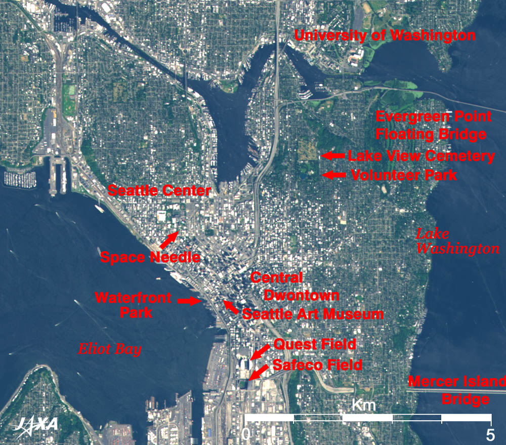
The center of the image is the Central Downtown area of Seattle where historic buildings and modern skyscrapers coexist. Many black shadows of the high-rise buildings are visible in this area. The Seattle Art Museum, whose landmark is the huge objet of the "Hammering Man," and the Pike Place Market, where seafood venders juggle their fish over the heads of amused spectators, are located here. Piers with many amusement facilities such as parks, an aquarium, and some large theaters are lined up at the waterfront in the western section (seaside) of the downtown area. The Seattle Aquarium, famous for its unique exhibitions, is located in the Waterfront Park. There are large sports facilities in the southern part of downtown. Safeco Field is the home of the professional major league baseball team the "Seattle Mariners," the team that Japanese player Ichiro Suzuki plays for. To the north is Quest Field where the "Seattle Seahawks", an American football team, play their home games. American football is one of the most popular sports in the United States. In the north of the downtown area is the general purpose park Seattle Center constructed on the former site of a World Exposition held in 1962. Many cultural institutions and amusement facilities are gathered here including the 184m high Space Needle with a UFO like disk on top of the tower. Volunteer Park, for citizen's recreation, and Lake View Cemetery, where Bruce Lee rests in peace, are located on Capitol Hill extending to the northeast of downtown. The two bridges over Lake Washington on the right-hand side of the image are very rare pontoon bridges. Both ends of the bridges are raised high enough above the water surface so that ship traffic can pass under. The University of Washington, founded in 1861 and now the largest university in the state of Washington, is located in the upper-right of the image. The whole image indicates that Seattle is blessed with an environment of rich nature surrounded by green and water. Puget Sound, created through the erosion of continental glaciers and embraced by narrow straits, is a good natural harbor. This area is rainy throughout the year, and the climate is rather warm for its high latitude. The Everett factory, used as the main factory of the Boeing Co. after 1960's, is located in Everett about 50km north of central Seattle; large air liners, such as the B-747 (Jumbo) and the B-767, are assembled there. The earliest assembly plant (called the "Red Barn") of the Boeing Co. was on the west side of King County International Airport several kilometers south of central Seattle. Seattle-Tacoma International Airport is visible several kilometers further south. In addition, the headquarters of Microsoft Corp. is located 20km east of central Seattle in Redmond at the northernmost end of Sammamish Lake. Although not included in the image, Olympic National Park with the temperate zone rain forests, which is on UNESCO's World Heritage list, is located in the west; and Mount Rainier National Park centering on Mount Rainier, which is loved as the "Fuji-San" of Tacoma by Japanese immigrants, is located in the southeast.
|
|||||||||||||||||||||||||||||||