| |
The World Cup Football event is held every four years. This year, beginning on June 9, the World Cup Football event will be held in Germany. Japan and South Korea co-hosted the games in 2002. The matches are planned in 12 cities including Hamburg, where Japan's Takahara plays, and Munich where the 1974 World Cup final match took place. Among these cities, Kaiserslautern, Nürnberg, and Dortmund, where the Japanese team will play, are introduced using the images observed by the earth-observation satellites.
 |
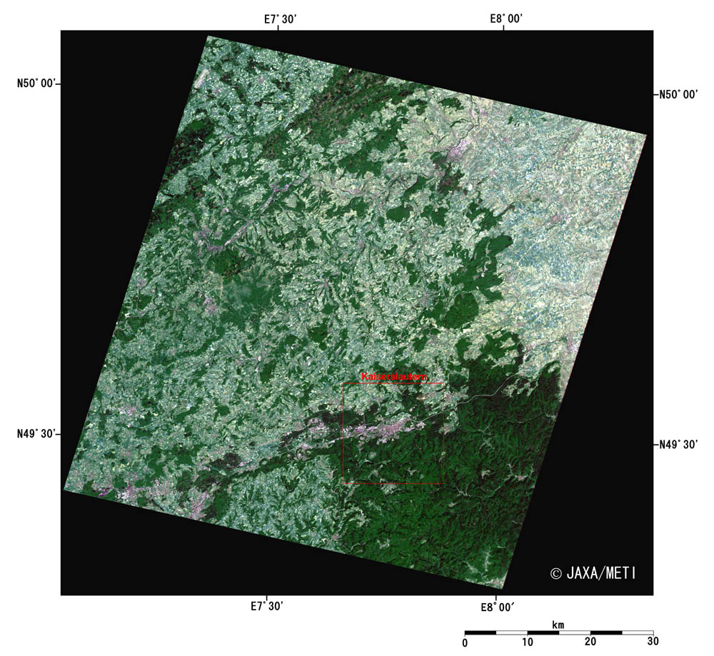
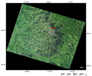
| Fig. 1. Kaiserslautern and Vicinity |
Figure 1 presents the vicinity of Kaiserslautern as observed by the optical sensor aboard the Japanese Earth Resources Satellite-1 (Fuyo-1) in June 1993. "Kaiser" (emperor), part of the city name, relates to the emperor Barbarossa (common name of Friedrich-I, meaning red beard) of the Holy Roman Empire in the 12th century. Fascinated with the landscape of this area, he established the castle here. Kaiserslautern is a small historic town with a population of 100,000 and many unique churches. The city area of Kaiserslautern is the purple-gray area adjacent to the dark-green forest at the lower right corner of the image.
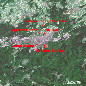 |
| Fig. 2. Close-up Image of Kaiserslautern |
Figure 2 is a close-up image of Kaiserslautern. Deep forests cover most of the image with pale green farmlands or pastures in the upper part of the image and the city area in the center. Fritz-Walter-Stadion, the stadium where the match between Japan and Australia will take place on June 12, is located on a small hill east of Kaiserslautern's Central Station. A church-dotted town can be observed from the seats of this football-specific stadium. The stadium was named after Captain Fritz Walter of the German team that became the glorious winner of the World Cup in Switzerland for the first time in 1954. This stadium is the home field of the veteran club team FC Kaiserslautern, called "Red Devils" in German.
Located on the north side of the station is the the longest outdoor pool in Europe, Waschmühle, which is 160m long. Also there are the 84m high City Hall and the Japanese garden, which is presently under construction, commemorating the establishment of a sister-city relationship with Bunkyo-ku, Tokyo.
 |
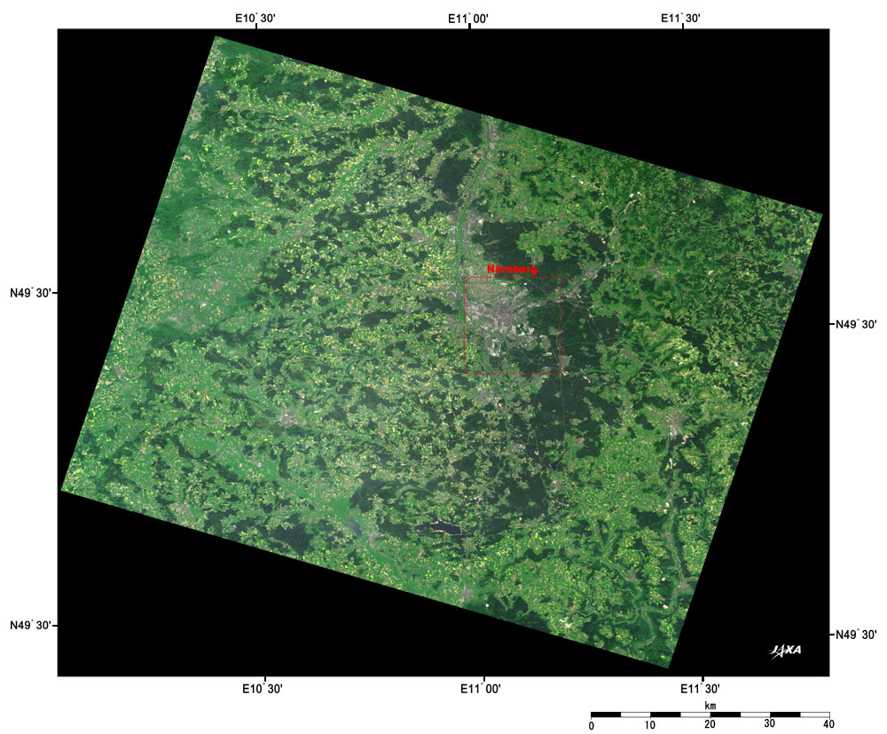
| Fig. 3. Nürnberg and Vicinity |
Figure 3 depicts the vicinity of Nürnberg as observed in May 1997 by the optical sensor AVNIR on board the Advanced Earth Observing Satellite (ADEOS) "Midori." The image is covered by patches of dark green forests. The purple-gray area in the center of the image is the urban area of Nürnberg. The center of the city, surrounded by the medieval castellated wall, is famous for the stage of Wagner's opera " Meistersinger von Nürnberg." This is also the place where Nazis Conventions took place in 1933 through 1938, and following World War II, the Nürnberg Tribunal brought war criminals to justice here.
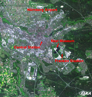 |
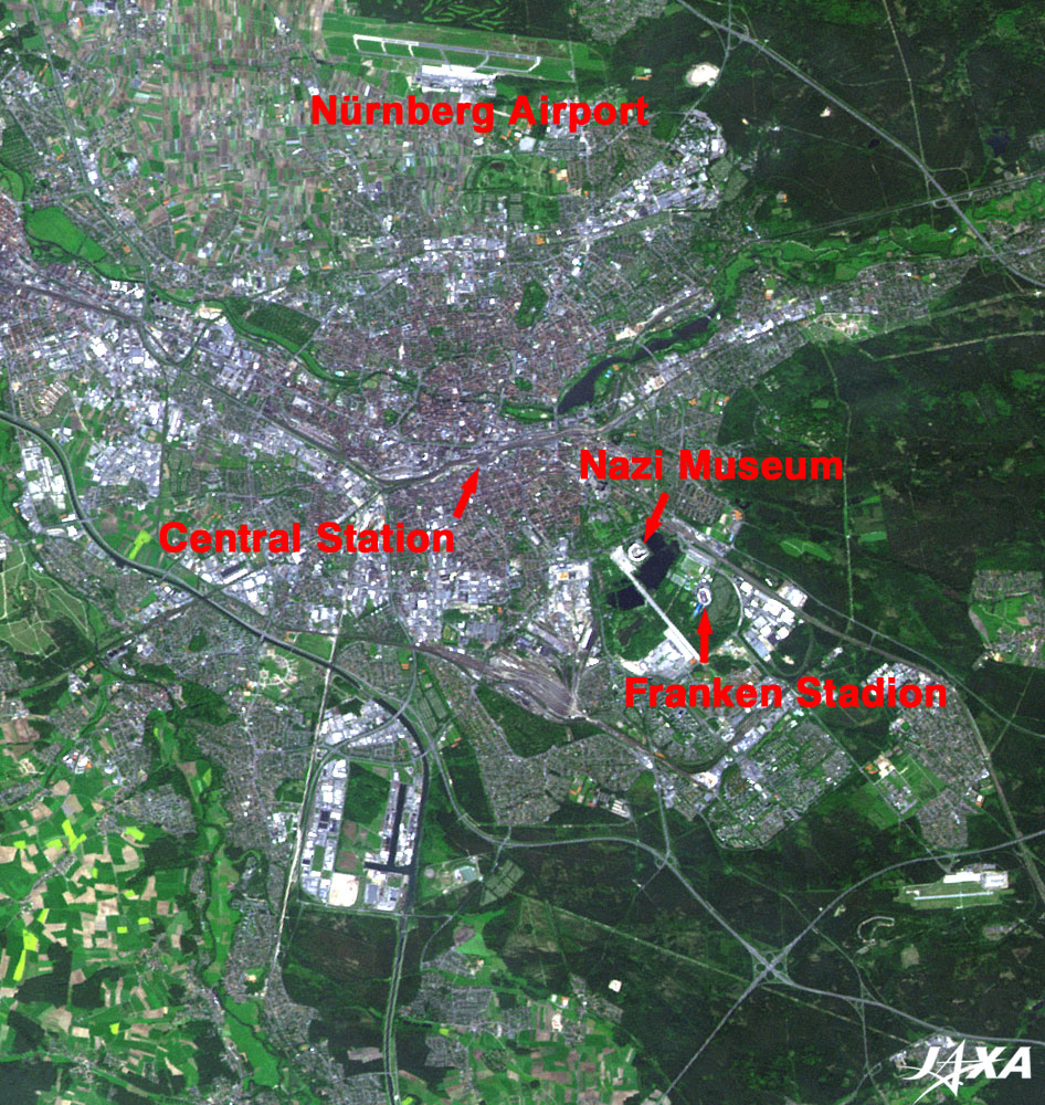
Fig. 4. Close-up Image of Nürnberg
Nürnberg (kmz, 1.64 MB, Low Resolution) as seen on Google Earth. |
Figure 4 is a close-up image of Nürnberg. The highway network system (Autobahn) surrounds the city. Nürnberg Airport is in the upper part of the image. North of Nürnberg Central Station is the old city area surrounded by the castellated wall where the old castle Kaiserburg, the toy museum, and other buildings are located. Although most of the old city was destroyed by the air raids during World War II, the city rose from the ashes of war and its medieval cityscape was restored.
On the east side of the station are the Nazi Museum and also Franken-Stadion where Japan and Croatia will compete on June 18. The stadium is named after the Kingdom of the Franks whose capital was located in this town. The elliptical stadium, complete with an athletic track, is located in a large green park in the suburbs. This stadium is the home field of the veteran club team FC Nürnberg, who won the German league championship five times during the 1920's at the beginning of their golden age.
 |
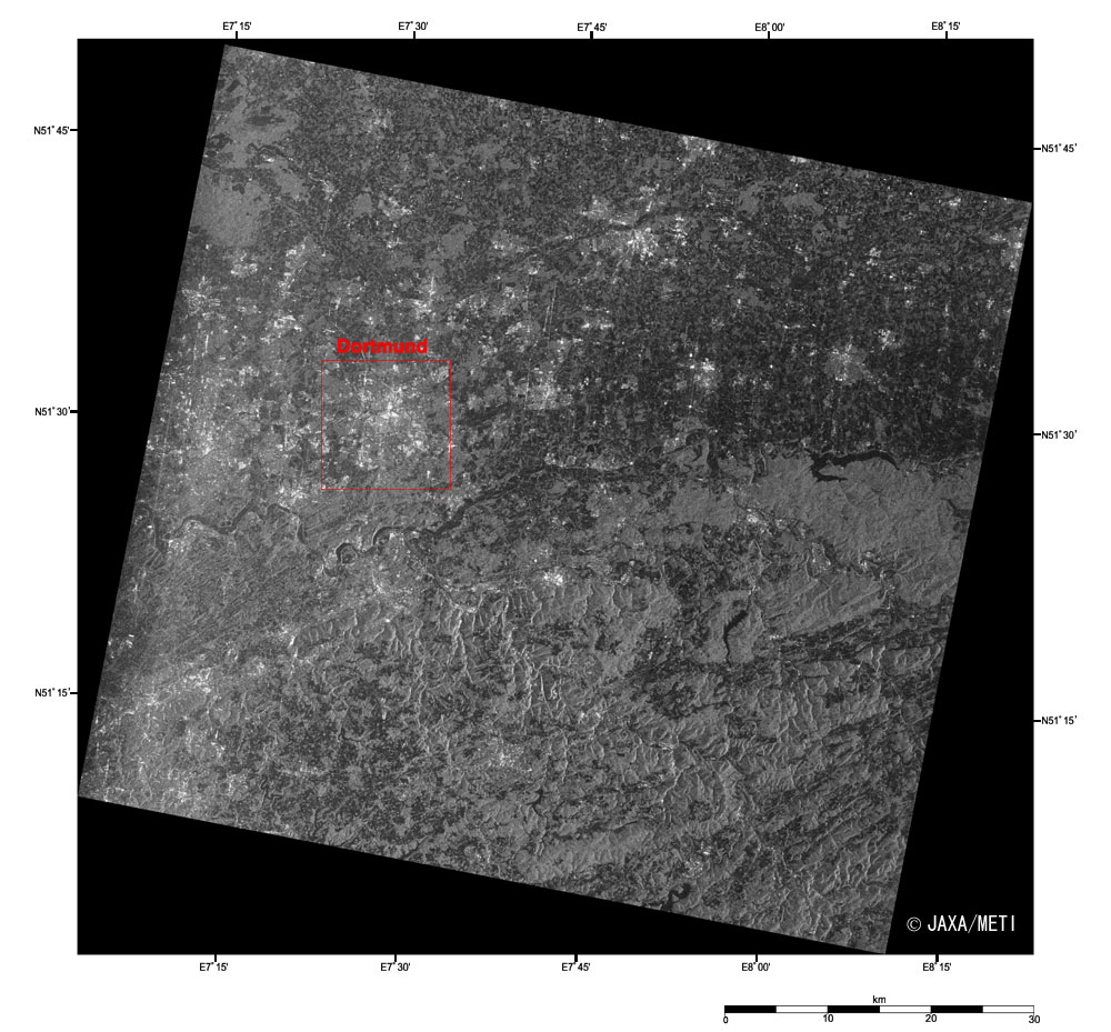
| Fig. 5. Dortmund and Vicinity |
Figure 5 is the vicinity of Dortmund as observed by the synthetic-aperture radar (SAR) on board Earth Resources Satellite-1 (Fuyo-1) in September 1996. Blessed with abundant coal mines, Dortmund is a typical industrial city of the Ruhr district, the largest heavy-industry area in Europe. It is also known as a major producer of German beer, like Munich. It was one of the Hanseatic League cities in medieval times.
The bright area in the center left of the image is the Dortmund urban area. Since the buildings of the street reflect the radar pulses emitted from the satellite, the urban area is bright. The black winding line in the center of the image is the Ruhr River flowing from east to west.
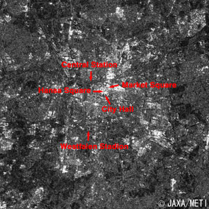 |
| Fig. 6. Close-up Image of Dortmund |
Figure 6 is a close-up image of Dortmund. Dortmund Central Station, Market Square near by, and Hansa Square appear darker and the City Hall looks bright. Westfalenstadion, the stadium where the match between Japan and Brazil will take place on June 22, is located in the green park a short distance from the city center south of the station. Since neither the trees in the park nor the stadium playing field reflects the radar signals, they look dark. The seats do reflect the radar wave and appear bright. This institution was one of the stadiums built for the Football World Cup in West Germany in 1974. It was the only football-specific stadium without an athletic track in those days. Borussia Dortmund, established in 1904, who won Bundesliga twice in the mid-1990s, play their home games here.
Most of Dortmund was also destroyed by the air raids during World War II. Following restoration, the city was reborn a more modern city, with IT industry and micro-system technology, quite a change from the typical coal, steel and beer towns of Germany.
Explanation of the images:
Figs. 1 and 2
| Satellite: |
Japanese Earth Resources Satellite-1 (JERS-1) (Fuyo-1) |
| Sensor: |
Visible and Near Infrared Radiometer (VNIR) |
| Date: |
June 30, 1993 |
| Ground Resolution: |
18.3 m x 24.2 m |
| Map Projection: |
Universal Transversal Mercator (UTM) |
The composite images are usually produced by assigning red to the visible Band 2 (630 to 690 nm), green to the near-infrared Band 3 (760 to 860 nm), and blue to the visible Band 1 (520 to 600 nm). This time, green is assigned to the sum of 75% of Band 2 and 25% of Band 3. The resulting images are very close to natural coloring seen by the naked eye.
In these images, the urban area is purple-gray, the forests are dark green, the grasslands and farmlands are light green or light brown, and water surfaces (rivers) are dark purple. Areas with no data are black.
|
Figs. 3 and 4
| Satellite: |
Advanced Earth Observing Satellite (ADEOS) (Midori) |
| Sensor: |
Advanced Visible and Near-Infrared Radiometer (AVNIR) |
| Date: |
May 16, 1997 |
| Ground Resolution: |
16 m |
| Map Projection: |
Universal Transversal Mercator (UTM) |
The composite images were produced using three visible bands out of four visible and near-infrared bands. Assigning red to Band 3 (610 to 690 nm), green to Band 2 (520 to 600 nm), and blue to Band 1 (420 to 500 nm) produces color-composite images with natural coloring as seen by the naked eye.
In these images, the urban area is gray, the forests are dark green, the grasslands and fields are light green or light brown, and water surfaces (rivers or ponds) are dark blue. Areas with no data are black.
|
Figs. 5 and 6
| Satellite: |
Japanese Earth Resources Satellite-1 (JERS-1) (Fuyo-1) |
| Sensor: |
Synthetic Aperture Radar (SAR) |
| Date: |
September 20, 1996 |
| Radio Frequency: |
1,275 MHz |
| Ground Resolution: |
18 m |
| Map Projection: |
Universal Transversal Mercator (UTM) |
| The brightness of the SAR image is caused by the reflection of the radar pulses scattered by ground objects. Water surfaces are seen as black, as they rarely return radar pulses to the satellite, but urban areas with their man-made structures are bright as they return radar pulses efficiently. The radar-pulse characteristics of forests are somewhat in between the water surfaces and the urban area, so the forests look gray. |
|
 |
|