| |
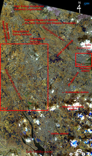 |
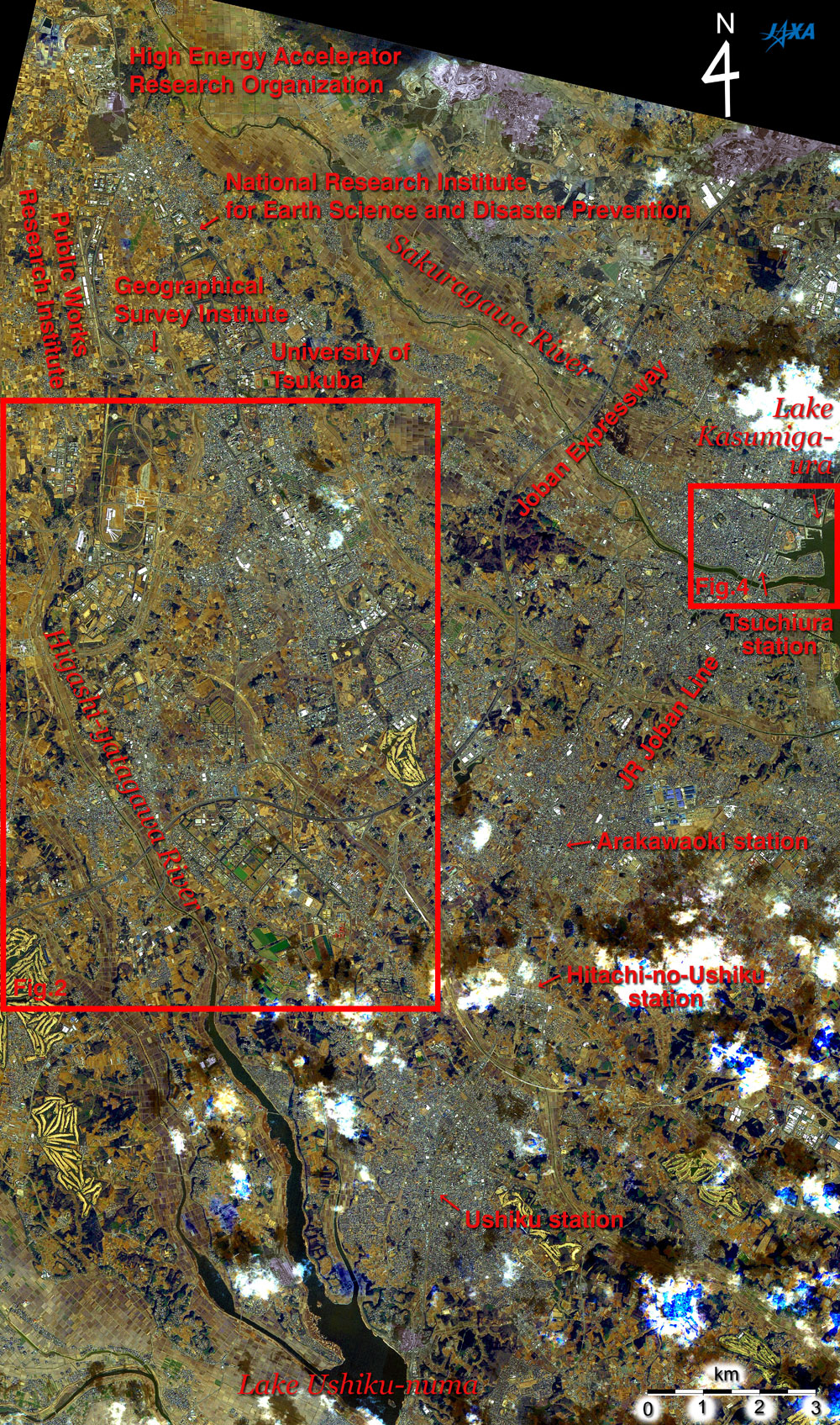
| Fig. 1 Tsukuba Science City and Vicinity |
Figure 1 is a pan-sharpened image around the Tsukuba Science City combining the data observed by the Panchromatic Remote-sensing Instrument for Stereo Mapping (PRISM) and the Advanced Visible and Near Infrared Radiometer type-2 (AVNIR-2) aboard the Advanced Land Observing Satellite (ALOS) "Daichi." Tsukuba Science City spreads outward from the center of the image to the upper left; and the city area of Tsuchiura City and the western end of Lake Kasumiga-ura can be seen on the right. Lake Ushiku-numa and the city area of Ushiku City can be seen at the bottom. The JR Joban Line extends from the bottom of the image to the upper right, and Ushiku station, Hitachi-no-Ushiku station, Arakawaoki station and Tsuchiura station appear in a row. Concurrent with the JR Joban Line, the Joban Expressway extends from the left to the upper right. Intersecting with these transportation lines, the Sakuragawa River flows from the upper left to the right and empties into Lake Kasumiga-ura. The Higashi-yatagawa River runs on the left and empties into Lake Ushiku-numa. Tsukuba Science City can be found in the area between the Sakuragawa River and the Higashi-yatagawa River and is on the west side of the JR Joban Line.
The High Energy Accelerator Research Organization is in the upper left of the figure. The ring indicates their gigantic accelerator. Named the B factory, this accelerator has a diameter of one kilometer and is used to research elementary particles by colliding electronic beams and positron beams head-on. The Public Works Research Institute, which has a test course approximately 3 km long in the north and south direction lies nearby, as do the Geographical Survey Institute, the National Research Institute for Earth Science and Disaster Prevention, and the University of Tsukuba.
Because every image was made with the same coloring as seen with the naked eye, the roofs appear red and blue, though the city areas look mostly bluish gray. The forests appear dark brown; the grasslands, the farmlands and the dried rice paddies look hazel; clouds are white; the shading of clouds is blackish, and the water surfaces appear black. Because the observation dates of PRISM and AVNIR-2 were different, the areas with clouds at the time of the AVNIR-2 observation and without clouds at the time of the PRISM observation appear gray. The areas with clouds at the time of PRISM and without clouds at the time of AVNIR-2 look white or partially blue within white.
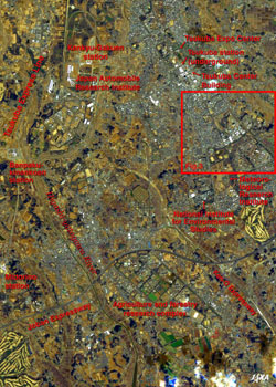 |
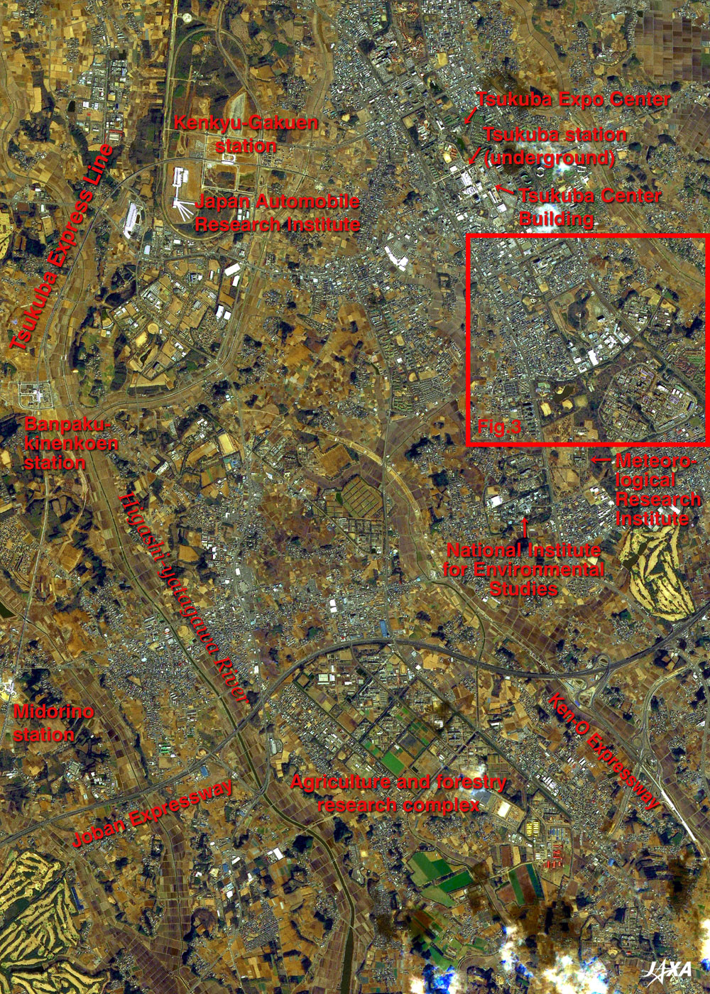
| Fig. 2 Expanded Image of the Central Area in Tsukuba Science City |
The Agriculture and Forestry Research Complex is on the southern side of the Joban Expressway extending east and west at the bottom of Fig. 2. The National Institute for Environmental Studies and the Meteorological Research Institute are on the northern side. The Metropolitan Inter-City Expressway (Ken-O Expressway) crosses the Joban Expressway, and a section on the northern side of the Joban Expressway that is under construction can be seen. The Tsukuba Express Line, which began operating in August of last year (2005), extends from the lower left to the upper left. Midorino station, Banpaku-kinenkoen (Expo'85 Memorial Park) station, and Kenkyu-Gakuen station lie in a row, and there are a few buildings around each station because the development there has just begun.
The northeastern area of Banpaku-kinenkoen station is where "the International Exposition, Tukuba, Japan, 1985" referred to as "TSUKUBA EXPO '85" was held in 1985. Today it has become a research complex for the institutes of high-tech companies and a park commemorating the exposition.
The big ellipse surrounding Kenkyu-Gakuen station was the test course of the Japan Automobile Research Institute, but it was relocated to Shirosato Town in the Higashi-ibaraki District in October of last year (2005) in order to develop the area around the station. The white buildings of the new crash test facility on the southwestern side of the station resemble the ribs of an umbrella.. There is another research complex on the west side of Kenkyu-Gakuen station. Tsukuba station, the terminal of the Tsukuba Express Line, is located in the underground of the Tsukuba center district where the Tsukuba Expo Center and the Tsukuba Center Building are located.
Generally speaking, the larger buildings are research facilities, public facilities, factories or large stores; and the smaller buildings are houses. A lot of farmlands and rice paddies still remain in this area.
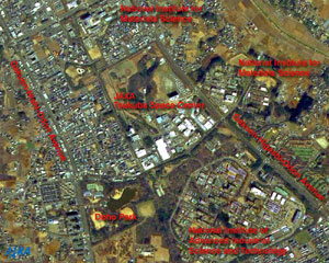 |
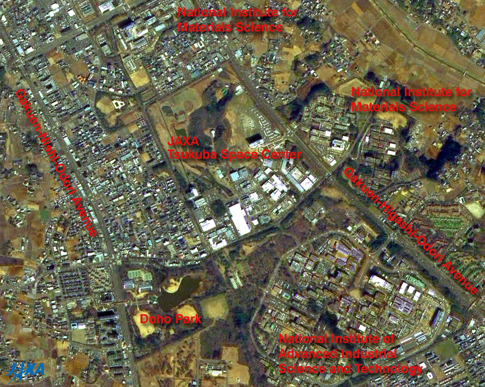
Fig. 3 JAXA's Tsukuba Space Center and Vicinity
Tsukuba (kmz, 2.06 MB, Low Resolution) as seen on Google Earth. |
The Tsukuba Space Center is at the center of Fig. 3; Doho Park is on the lower left; the National Institute of Advanced Industrial Science and Technology is on the lower right; the National Institute for Materials Science (Namiki area) is on the right, and the National Institute for Materials Science (Sengen area) is in the upper area. Gakuen-Higashi-Odori Avenue and Gakuen-Nishi-Odori Avenue extend to the northwest and southeast directions.
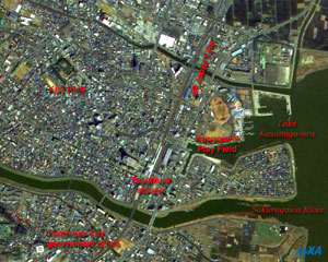 |
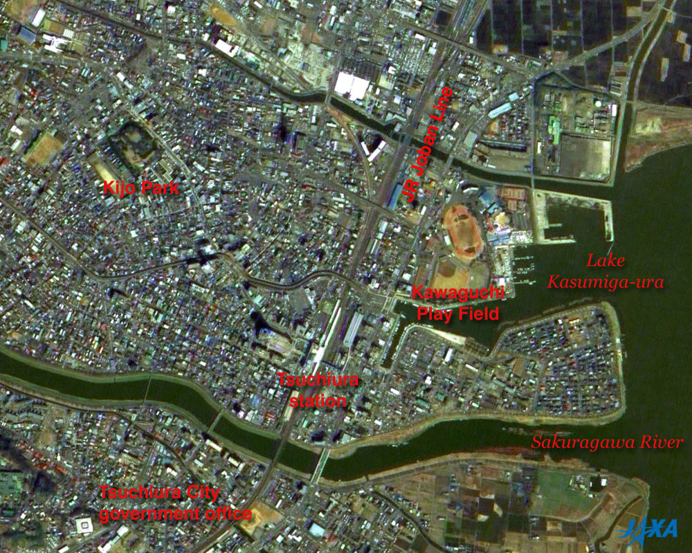
| Fig. 4 Center of Tsuchiura City |
Lake Kasumiga-ura is on the right of Fig. 4, and the Sakuragawa River flows from west to east at the bottom of the figure and empties into Lake Kasumiga-ura. Tsuchiura station can be seen at the center of the figure, and the JR Joban Line extends north and south. The Kawaguchi Playing Field is to the northeast of Tsuchiura station, and the Tsuchiura City government office is in the southwest. Kijo Park, the remnants of the Hon-maru (the main citadel) and the Nino-maru (the middle citadel) of Tsuchiura Castle, is in the upper left of the image.
Tsuchiura Castle was a "Hirajiro" or flatland castle and was called "Kijo" meaning turtle castle because of its shape with a five-fold moat resembling a turtle afloat on the water. It is said that the beginning of the Tsuchiura Castle was when Masakado Taira built a fortress there around 940. The layout of the castle was arranged about 1430 during the Muromachi Era, and the castle was extended and rebuilt in the first half of the Edo Era. During those periods, the lords of the castle quickly took the place, but the Tsuchiya Family served as the master generation after generation over the approximately 200 years since 1669. After entering into the Meiji Era (1868 - 1912), Tsuchiura Castle was used for the Tsuchiura Prefectural Government Office, the Niihari Prefectural Government Office, and so on. The Yagura-mon (turret gate), which has another name: the Taiko-Yagura (drum turret), still stands. The Kasumi-mon (haze gate), part of the Hon-maru moat (the inner moat) and the Nino-maru moat (the middle moat), the earthen works and so on are all presently standing. The "Yagura-mon" is a tower gate ( a two-story gate with a turret), and it is said to be the only remaining structure built in the first half of the Edo Era in the Kanto District. In addition, the "Nishi-yagura" (western turret) and "Higashi-yagura" (eastern turret) have been restored.
JAXA has completed the initial checkout activities of the Advanced Land-Observing Satellite "Daichi" (ALOS) and moved to the initial calibration and validation phase on May 15.
Explanation of the images:
Figs. 1 to 4
| Satellite: |
Advanced Land Observing Satellite (ALOS) (Daichi) |
| Sensor: |
Panchromatic Remote-sensing Instrument for Stereo Mapping (PRISM)andAdvanced Visible Near Infrared Radiometer type-2 (AVNIR-2) |
| Date: |
1028 (JST) on March 27, 2006 (PRISM) and 1044 (JST) on March 25, 2006 (AVNIR-2) |
| Ground resolution: |
2.5 m (PRISM) and 10 m (AVNIR-2) |
| Map Projection: |
Universal Transversal Mercator (UTM) |
PRISM is an optical sensor for observing ground surfaces with visible and near-infrared signals in the 520 to 770 nano-meter (one-billionth of a meter) band. The acquired image is monochrome. PRISM has three independent optical systems (telescopes) to acquire terrain data including altitude data so that images for nadir, forward, and backward views can be acquired at the same time. Only nadir images were used in this article.
AVNIR-2 is equipped with a pointing function by which it can shift its observation area perpendicular to the ALOS's moving direction, and it can observe ground surfaces with four spectral bands.
At first, the color image was made by using three out of four AVNIR-2 bands: visible (610 to 690 nm, band 3) for red, visible (520 to 600 nm, band 2) for green, and visible (420 to 500 nm, band 1) for blue. Second, the image was transformed into Hue, Saturation and Intensity, and the Intensity was replaced by the PRISM image. The Hue, Saturation and Intensity data were then reversed into a color image. As a result, a virtual 2.5 m ground-resolution color image was obtained. This kind of high-resolution color image, composed by combining the higher resolution monochrome image and the lower resolution color image, is called a pan-sharpened image. These images have a natural coloring, and they can be interpreted as follows.
|
| Dark brown: |
Forests |
| Light brown: |
Grasslands, farmlands, or dry rice paddies |
| Bluish gray: |
City area or roads |
| Red, blue, white, etc.: |
Roofs of buildings |
| Black: |
Water surfaces (lakes or rivers) |
|
 |
Related Sites:
 ALOS Research and Application Page ALOS Research and Application Page
Three-Dimensional View of Mt. Haruna
Sendai and Yamagata: Two Prefectural Capitals east and west of Zao
The Town with a Double Moat: Shizuoka City
Land, Seen from Space
Appendix:
The decision to build Tsukuba Science City was made in September 1963 based on an understanding reached at a cabinet meeting in order to build up a base for conducting high-level research and education and to cope with the overcrowded conditions in Tokyo. The relocation of about forty national experimental and research institutions, the foundation of the University of Tsukuba, and the construction of their facilities were, for the most part, completed by March 1980. In November of 1987, Tsukuba City was born after three towns (Yatabe Town, Oho Town and Toyosato Town) in the Tsukuba District and Sakura Village in the Niihari District merged. The population of Tsukuba City is now approximately 200,000 and has roughly 300 national and private research institutions and corporations employing approximately 13,000 researchers.
|
|