| |
 |
| Fig. 1. Ulaanbaatar and Vicinity |
Figure 1, observed by the optical sensor aboard the Japanese Earth Resources Satellite-1 (JERS-1) in May 1996, depicts Ulaanbaatar, the capital of Mongolia and its vicinity. The deep green massif in the center of the image is the Bogd Khaan Uul (Mt. Bogd Khaan). On the northern side of Bogd Khaan Uul the Tuul Gol (Tuul River) flows from east to west. The Ulaanbaatar urban area is represented as the purple-gray area beside the Tuul River. The deep-green forest of Mt. Chingeltei can also be seen in the upper part of the image. Ulaanbaatar is located in the basin on the southwestern edge of the Hentiy Range. It is surrounded by mountains, which protect the city from the heavy winds of the plains. The Buyant-Ukhaa International Airport is southwest of the city area.
Three quarters of Mongolia is dry prairie; most of the remainder being barren desert, with less than 10% being forest. Forests in Mongolia grow mostly on the northern slopes of the mountains, as there is not enough rainfall for forest to grow on the sunlit southern slopes. The forest fires that broke out in Mongolia during 1996 to 1998 destroyed approximately 4 million hectares of forest, the equivalent of almost 10% of the total area of Japan. The dark brown area in the upper right and the central area of the image are the burn scars from these fires. The smoke from the fire in the upper right corner is represented in purple. The grasslands or farmland are represented in light green. White clouds cast their shadows upward.
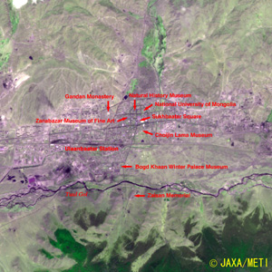 |
Fig. 2. Expanded View of the Urban Area in Ulaanbaatar
Ulaanbaatar (kmz, 2.34 MB, Low Resolution) as seen on Google Earth. |
Figure 2 is an expanded image of the urban area in Ulaanbaatar. The streets and roads in the central area of the city outline the shape of a yurt, the nomad's mobile tent house. The roads and public facilities were designed based on the city planning of the Soviet Union system after the end of World War II in 1945. At the center of the city is the square that commemorates Sukhbaatar, the hero of the communist revolution. The Government buildings, National University of Mongolia, the Opera Theater, the Ministry of Foreign Affairs and the City Hall are arranged around the square.
North to northwest of the square is the Natural History Museum, which is famous for its dinosaur fossils. The Zanabazar Museum of Fine Art that commemorates the priest Zanabazar (Mongolia's Leonardo da Vinci), and the Gandan Monastery with the 26m high statue of the Deity of Mercy (Kannon) is also located north of the square. Toward the south is the Choijin Lama Museum, which was built as a temple to the younger brother of the eighth living Buddha. A little further southwest from the square is the Bogd Khaan Winter Palace Museum. The eighth living Buddha used this as his winter royal palace. Also located to the south is the Ulaanbaatar Station, which is the main relay point for international trains connecting Moscow and Beijing, and Zaisan Memorial hill, which overlooks the city. Some Soviet style multi-family, medium-rise, housing in the western area of the city show geometric pattern accompanied by their shadows northward.
Sumo wrestlers from Mongolia, such as the grand champion Yokozuna Asa-sho-ryu, Hakuho, with the second highest rank of Ozeki, and the first Mongolian Sumo wrestler Kyoku-shu-zan, have achieved great success in the Sumo World in Japan. They have recently been contributing to the popularity of the Grand Sumo Tournament.
Explanation of the images:
Fig. 1 and Fig. 2
| Satellite: |
Japanese Earth Resources Satellite-1 (JERS-1) (Fuyo-1) |
| Sensor: |
Visible and Near Infrared Radiometer (VNIR) |
| Date: |
May 14, 1996 |
| Ground Resolution: |
18.3 m x 24.2 m |
| Map Projection: |
Universal Transversal Mercator (UTM) |
| The composite figures were produced by assigning red to the visible channel (630 to 690 nm), green to the near-infrared channel (760 to 860 nm), and blue to the visible channel (520 to 600 nm). The resulting figures have natural coloring, except for a slightly emphasized green for vegetation, and appear as though seen by the naked eye. In these images, the clouds are white, the urban area is light purple, the forests are dark green, the grasslands and farmland are light green or light-brown, northern slopes are dark, burn scars are dark brown, and the water surface is black. Areas with no data are also black. |
|
 |
Related Sites:
 Soil Moisture Maps of Mongol Plateau --Soil Moisture Observation from Satellites Now Practical-- Soil Moisture Maps of Mongol Plateau --Soil Moisture Observation from Satellites Now Practical--
World Heritage Site Surrounded by High-rise, Multifamily Housing: St. Petersburg
Land, Seen from Space
Appendix:
Ulaanbaatar was developed as a dwelling place for the Mongolian living Buddha, Jabtsundamba Khutuktu. In the beginning, Khutuktu and his followers lived in a yurt temple as semi nomadic herders. In the middle of the 19th century, he ceased the nomadic life, built a temple, and settled in what is now called Ulaanbaatar. His followers built temples and the temple town became a pilgrimage site that developed into the present city. "Ulaanbaatar" means "red hero" in Mongolian.
The population of Ulaanbaatar was 930,000 in 2004. This is more than one-third of the population of the country (2,530,000), which creates an extreme over-concentration of people in Ulaanbaatar.
Ulaanbaatar is 1,351 m above sea level. The dry air and lack of rainfall make the temperature difference between day and night, or winter and summer quite large. The air temperature during the day in summer (July or August) may be 40 degrees Celsius but it may drop to less than minus 40 degree Celsius in the long, cold winter months from November to April. It is known as "the coldest capital in the world" together with Ottawa, Canada. However, there are as many as 250 clear days annually.
Mongolia has suffered from frequent natural disasters in recent years. More than 10 million livestock were lost during the summer droughts of 2000 and 2002. There was also snow damage (Dzud) during the winters of 1999-2000, 2000-2001 and 2002-2003. The rapid shift from a socialist economy to a free market economy, which took place after the collapse of the former Soviet Union in 1991, triggered the following chain reaction that intensified these natural disasters. The increase in unemployment created a rapid increase of inexperienced nomads. This increased livestock, including cashmere goats that eat plants by the roots, leading to overgrazing, which in turn made the damage by natural disasters serious. Following the collapse of the local grazing economy, many nomads returned to Ulaanbaatar and built unauthorized yurts in the suburbs. This expansion of the "Yurt District" created various social problems.
|
|


