Seen from Space 2004
AMSR-E captures Kuroshio's Large Meander
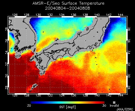
AMSR-E captured a large meander of the Kuroshio current. Figure 1 depicts the five-day averaged sea-surface temperature (SST) south of Honshu observed by AMSR-E aboard the Aqua satellite August 4 to 8, 2004. The northernmost edge of orange or red area where SST exceeds 26°C corresponds to the Kuroshio current. You can clearly see the Kuroshio meandering in the shape of an "U" from off the Kii Peninsula to off Tokai going mostly southward away from the seashore. On August 4, the Japan Meteorological Agency (JMA) announced that the small meander of the Kuroshio that occurred east of Kyushu last year, continuing eastward, has become the "large meander path (*1)" separating widely from offshore Tokai. It is highly possible for the Kuroshio Current to grow into a large meander for the first time in 13 years. There is concern that this could affect high tides and influence fisheries.
If a large meander takes place, a counter-clockwise circular current is generated inside the U-shaped current of Kuroshio. The surrounding sea-surface height (tidal level) is elevated comparable to the water level of an eddy gradually increasing in the radial direction. If higher tidal levels continue while the large meanderremains the same, and the spring tide (*3) occurs at the same time, it will be necessary to monitor flooding in the coastal lowlands. Additionally, if a typhoon is coming, high tide may occur. According to the fishery and sea condition information published by the Fisheries Research Institutes of Aichi Prefecture and Shizuoka Prefecture, catches of whitebait and mackerel are poor offshore of Tokai this year, but the opposite is true regarding skipjack tuna catches off Cape Omaezaki. Researchers are investigating the relationship between these phenomena and the large meander of the Kuroshio (*4). The information on the path and location of the Kuroshio is very important not only for the safe and economic navigation of ships but also for disaster prevention in the coastal regions and fisheries. According to a JMA press release, this large meander of the Kuroshio is predicted to last for the next several months. JAXA EORC will keep monitoring the trend of the Kuroshio by observing SST distribution from space. Please see the latest images observed on the Kuroshio monitoring page. (*1) AMSR-E is a microwave sensor with wide frequency bands capable of accurately acquiring information regarding weak radiation from the Earth's surface and atmosphere and obtaining necessary data for the study of Earth hydrologic circulation. Microwave sensors, unlike optical sensors, can continuously monitor night and day regardless of weather; the trend of the Kuroshio current can thus be monitored continuously. (*2) Please refer to the past topics "Movement of the Kuroshio Current" for a general explanation of the Kuroshio path. (*3) Seawater on the Earth moves due to the attraction of the Sun and and is especially affected by the moon. The tidal level (high tide) occurs when seawater is pulled near the shore by the gravity of the Moon, and low tide occurs when the seawater is pulled away from the shore. When the Earth, Moon and Sun are located in a straight line (at the new and full Moon), more seawater than usual is pulled near by the combined gravity of the Moon and Sun. The difference between the high and low tides reaches its maximum. This is called the spring tide. (*4) The distribution of fish may become small or the migration routes change as the path of the Kuroshio approaches approaching or moves away from the coast. The fishing grounds move because the low-temperature area (cold water mass) is formed between the meandering path and southern coast of Honshu due to cold water that up-wells from deeper water.
|
|||||||||||||